Scan to BIM vs Manual Measurement for As-Built Surveys
The right choice in scan to BIM vs manual measurement depends on project scale, geometry, required deliverables, tolerance, site access, and the cost of missing information. Manual measurement is efficient for small,…
Scan to BIM vs manual measurement: Quick answer
The right choice in scan to BIM vs manual measurement depends on project scale, geometry, required deliverables, tolerance, site access, and the cost of missing information. Manual measurement is efficient for small, selective scopes with simple geometry. Scan-to-BIM is usually better suited to complex or larger existing buildings where teams need dense existing-conditions data, point clouds, coordinated drawings, or a Revit/BIM model.
Choosing a building measurement method is not a technology contest. The scan to BIM vs manual measurement decision should be based on what the project actually requires. Architects, contractors, developers, property managers, and permitting teams need the method that captures enough reliable information for the next design or construction decision without creating unnecessary fieldwork or processing. The comparison starts with one question: what must the final as-built deliverable allow the project team to do?
How manual measurement and Scan-to-BIM capture existing conditions
Manual measurement records dimensions and observations one by one. A technician may use a tape measure, laser distance meter, sketches, photographs, and field notes to document wall lengths, openings, ceiling heights, and required features. The method can be efficient when the scope is narrow because the field team captures only what the drawings require.
3D laser scanning uses LiDAR-based reality capture to record dense spatial data from visible building surfaces. Multiple scan positions are registered into a coordinated point cloud, which becomes a measurable digital record of the existing conditions. That point cloud can then support as-built drawings, CAD drafting, sections, elevations, reflected ceiling plans, and Scan-to-BIM modeling.
The operational difference is data density. Manual workflows depend on choosing the correct measurements while on site, while scanning captures a much broader spatial record that can be interrogated later. This matters when design questions change after the survey, when irregular geometry must be reconstructed, or when several disciplines need information from the same existing-condition dataset. This difference in data density is central to the scan to BIM vs manual measurement comparison.
Decision summary
Choose manual measurement when the building area is limited, geometry is straightforward, and the required output depends on a defined set of dimensions. Choose Scan-to-BIM when missing one condition could trigger a revisit, when geometry is complex, or when the project needs coordinated 2D and 3D deliverables from one capture. In scan to BIM vs manual measurement, the appropriate choice follows project scope rather than technology preference.
Scan to BIM vs manual measurement: building measurement methods compared
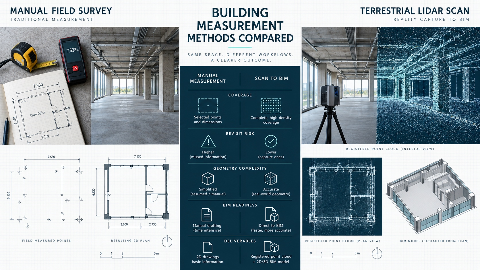
Compare the complete workflow from field capture to the drawings or model used by the project team. A fast field method can still be inefficient if it creates drafting gaps, while a data-rich method may be excessive when the project only needs a few verified dimensions. A broader comparison of 3D laser scanning and traditional surveying also shows why coverage, accuracy, field time, cost, and project type should be considered together.
| Decision factor | Manual measurement | Scan-to-BIM / 3D laser scanning |
|---|---|---|
| Field capture | Selected dimensions, sketches, photos, and notes | Dense point-cloud capture from multiple scan positions |
| Geometry | Best suited to simple or clearly defined geometry | Strong fit for irregular, layered, curved, or congested geometry |
| Coverage | Limited to measurements intentionally recorded on site | Broad visible-surface coverage that can be measured after field capture |
| Human-error exposure | Higher dependence on field notation, transcription, and measurement selection | Automated spatial capture reduces manual transcription but still requires sound scan planning and registration |
| Revisit risk | Higher if a required dimension was not captured | Lower when the required condition is visible in the registered point cloud |
| Typical deliverables | 2D floor plans, selected elevations, basic sections, dimension schedules | Point cloud, floor plans, elevations, sections, RCPs, DWG/PDF, and Revit/BIM models |
| BIM integration | Requires manual reconstruction from notes and dimensions | Point cloud provides a direct geometric reference for Revit/BIM modeling |
| Best project fit | Small or selective scopes | Complex, larger, coordination-heavy, or model-driven scopes |
In short: Laser scanning vs tape measuring is primarily a question of coverage and downstream use. Manual measurement captures the dimensions you anticipated; scanning preserves a broader spatial record for later drafting, coordination, and modeling.
How scope, accuracy, and cost should drive scan to BIM vs manual measurement
Define project scope before selecting the capture method. A survey for one retail unit has different requirements from a multi-level renovation or MEP coordination project. Identify which spaces, systems, surfaces, and disciplines must be represented and which deliverables will be issued.
Accuracy should be specified as a project requirement
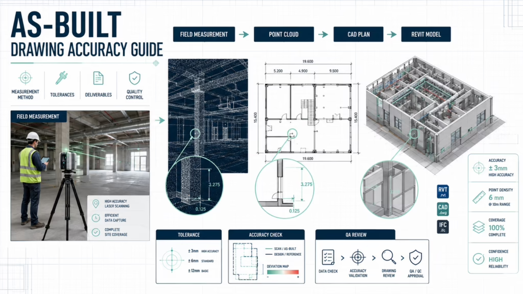
Accuracy is not created by naming a device. Scanner quality, scan position, line of sight, surface characteristics, registration, field procedure, and modeling decisions all affect the result. These variables are also discussed in guidance on measured building survey accuracy using laser scanning. MeasureBuilt may use a typical ±5 mm figure where appropriate, but the required tolerance should be confirmed for the specific project and deliverable.
Cost should be evaluated across the full workflow
The cost difference between scanning and manual survey has no universal ratio. Manual measurement can have the lower entry cost for a small, simple space. Scanning can create better value on larger or complex scopes when it reduces field labour, supports multiple deliverables, or helps avoid return visits.
Compare field time, site access, drafting or modeling effort, remobilization risk, deliverable count, and the consequences of missing dimensions. In an occupied commercial property, reducing repeated access may matter more than minimizing the initial survey fee. Published comparisons of Scan-to-BIM and traditional surveying similarly evaluate cost, speed, accuracy, and deliverable requirements together.
In short: Compare total project effort, not equipment cost. The lowest-cost capture method is the one that supplies enough verified information for the required deliverables without creating avoidable rework or site revisits.
When manual measurement is the right method
Manual measurement remains a practical choice when the scope is limited and the required geometry is easy to verify directly. Traditional survey vs 3D scanning should not be framed as obsolete versus modern; point-based measurement is still efficient when comprehensive spatial capture would add processing without adding useful project information. For scan to BIM vs manual measurement, small and selective scopes often remain strong candidates for manual capture.
- Small interiors: a compact suite, room, or isolated renovation area with straightforward walls and openings.
- Selective verification: a contractor or designer needs several dimensions rather than a full existing-conditions package.
- Simple 2D deliverables: the required output is a basic floor plan or limited drawing set without a coordinated BIM model.
- Accessible geometry: relevant surfaces and endpoints can be reached and measured safely without extensive obstruction.
- Low change risk: the survey scope is stable, so the team is unlikely to request many additional dimensions after the site visit.
Manual measurement becomes less attractive when the field technician must make many judgment calls about what to record. Every omitted height, offset, wall thickness, beam position, ceiling condition, or opening can become a drafting question later. If a return visit would delay design or require difficult site access, broader reality capture can be the safer workflow.
When to use Scan-to-BIM for existing buildings
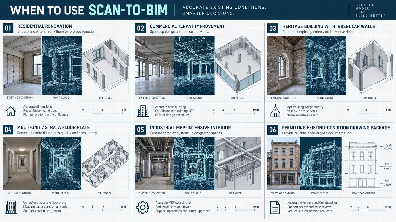
Scan-to-BIM is most useful when the project needs a reusable geometric record rather than a short list of dimensions. The point cloud gives architects and BIM teams a dense reference for existing conditions, spatial relationships, coordinated drawings, and Revit modeling. In the scan to BIM vs manual measurement decision, this broader reusable dataset is one of the strongest reasons to choose scanning.
Residential renovations
Scanning suits larger renovations where several rooms, levels, stairs, roof conditions, or non-orthogonal walls must coordinate. Manual measurement can still suit a small alteration, but whole-house redesigns benefit when designers can return to the point cloud for additional dimensions.
Commercial tenant improvements
Commercial tenant improvements often require floor plans, RCPs, ceiling heights, columns, storefront conditions, and service spaces. A point cloud can support that design work when legacy drawings are incomplete. BOMA should be limited to commercial area calculations, leasing, and square-footage verification, not treated as a general scanning standard.
Heritage and irregular buildings
Heritage buildings are strong scanning candidates because walls, openings, floors, façades, and structural features may not be square, level, or repetitive. Dense capture records irregular geometry more effectively than a small set of assumed straight-line dimensions.
Multi-unit and strata properties
Multi-unit and strata projects require consistency across suites, common areas, corridors, stairs, and service spaces. Scan-based capture can provide one geometric reference for a coordinated package and reduce variation in what different field crews record.
Industrial and MEP-intensive spaces
Industrial interiors and MEP-intensive spaces contain pipes, ducts, equipment, structure, and overhead services that are difficult to describe with isolated dimensions. 3D laser scanning is useful when teams need visible spatial relationships, clearances, and routing context.
Permitting and existing-condition drawing packages
Permitting teams need clear existing-condition drawings rather than a point cloud by itself. Scanning can support floor plans, elevations, sections, and site information where geometry is complex or record drawings are incomplete. The final package should match the submission requirements.
Choose the capture method by the required deliverables
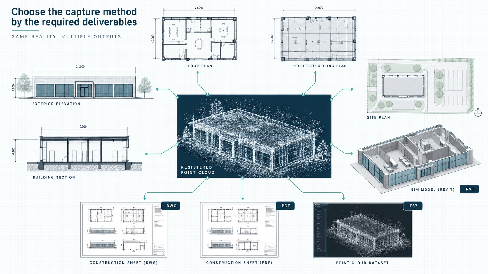
Deliverables should be defined before field capture because they determine what must be visible, measured, modeled, and checked. A request for floor plans alone is not equivalent to a request for a coordinated Revit model, even when both begin with the same building. Deliverables are therefore an important part of the scan to BIM vs manual measurement choice.
| Deliverable | What it needs from the survey | Method implication |
|---|---|---|
| Floor plans | Wall geometry, openings, columns, stairs, key fixtures, level relationships | Manual can suit simple plans; scanning helps with larger or irregular layouts |
| Elevations | Façade planes, openings, vertical relationships, architectural features | Scanning is strong where elevations contain complex or irregular geometry |
| Sections | Floor-to-floor heights, slabs, roofs, stairs, structure, vertical offsets | Scanning reduces dependence on isolated height measurements |
| Reflected ceiling plans | Ceiling boundaries, soffits, grids, fixtures, visible services | Scanning can improve coverage in coordination-heavy interiors |
| Site plans | Building position and visible site features within the defined scope | Method depends on required extent, control, and site conditions |
| Revit/BIM model | Consistent 3D geometry and an agreed modeling scope | Point cloud is a strong reference for LOD 100–300 existing-condition modeling |
| DWG / PDF | Drafted and checked 2D documentation | Either method can support output; complexity determines the efficient capture route |
| RVT | Structured model geometry and agreed Revit deliverable requirements | Scan-to-BIM is normally the more direct workflow |
| Point cloud | Registered scan data | Requires 3D scanning or another compatible reality-capture workflow |
A point cloud and a BIM model are not interchangeable deliverables. The point cloud is measured spatial data; the Revit/BIM model is an interpreted, structured representation created from that data. Modeling therefore requires decisions about object scope, LOD, simplification, exclusions, and how irregular existing conditions will be represented.
Accuracy, registration, and scope requirements to define before the survey
Reliable as-built documentation starts with a written scope, not a scanner specification. State what is captured, what is excluded, which deliverables are required, what tolerance is relevant, and how the data will be used. This prevents a technically successful survey from producing the wrong information for design.
- Define the survey extent: identify floors, suites, façades, roofs, service spaces, exterior areas, and inaccessible zones.
- Define the deliverables: specify floor plans, elevations, sections, RCPs, site plans, point cloud, DWG, PDF, RVT, or a Revit/BIM model.
- Define model scope: state which architectural, structural, or visible MEP elements must be represented and the intended LOD where BIM is required.
- Define accuracy expectations: match tolerance to the project decision rather than assuming every element needs the same precision.
- Define coordinate requirements: confirm whether local coordinates are sufficient or whether the dataset must tie into project control.
- Define acceptance criteria: confirm file versions, naming, completeness, and what the client will review before final delivery.
Laser scanners record surfaces visible from their scan positions. Furniture, equipment, finishes, or inaccessible areas can create occlusions. Registration combines multiple scan positions into one coordinated dataset, so good scan planning is essential for reducing blind spots and producing a coherent point cloud.
In short: A dense point cloud is useful only when capture extent, registration, tolerance, and deliverables match the project brief. Scope quality is part of measurement quality.
How to select an as-built measurement provider
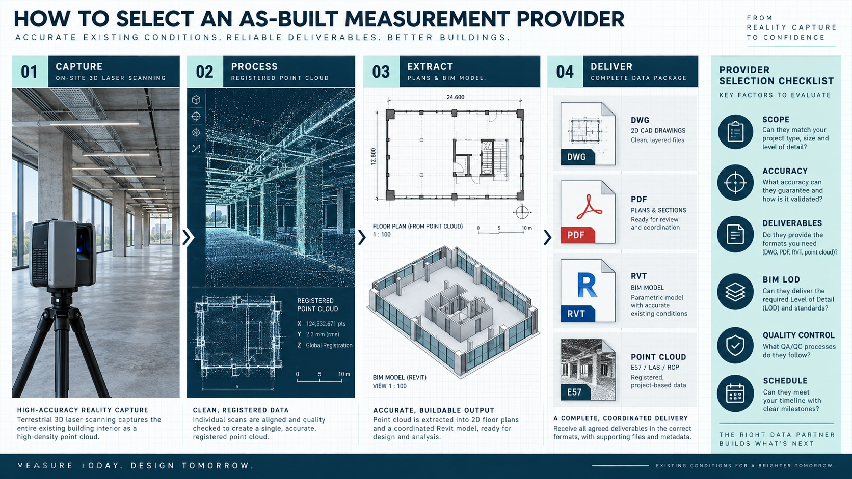
Provider selection should cover the complete field-to-deliverable workflow. A company may capture good scan data yet still create coordination problems if model scope, drawing content, or quality checks are unclear. Ask how captured geometry becomes the exact files your team will use and how the provider decides between scan to BIM vs manual measurement for different project conditions.
- Technology: Confirm the provider can use manual measurement, 3D laser scanning, or a hybrid workflow based on the project rather than forcing one method.
- Survey scope: Confirm the provider identifies capture boundaries, inaccessible areas, exterior requirements, and discipline-specific needs before mobilization.
- Accuracy: Ask how field procedure, registration, and deliverable checks are matched to the required project tolerance.
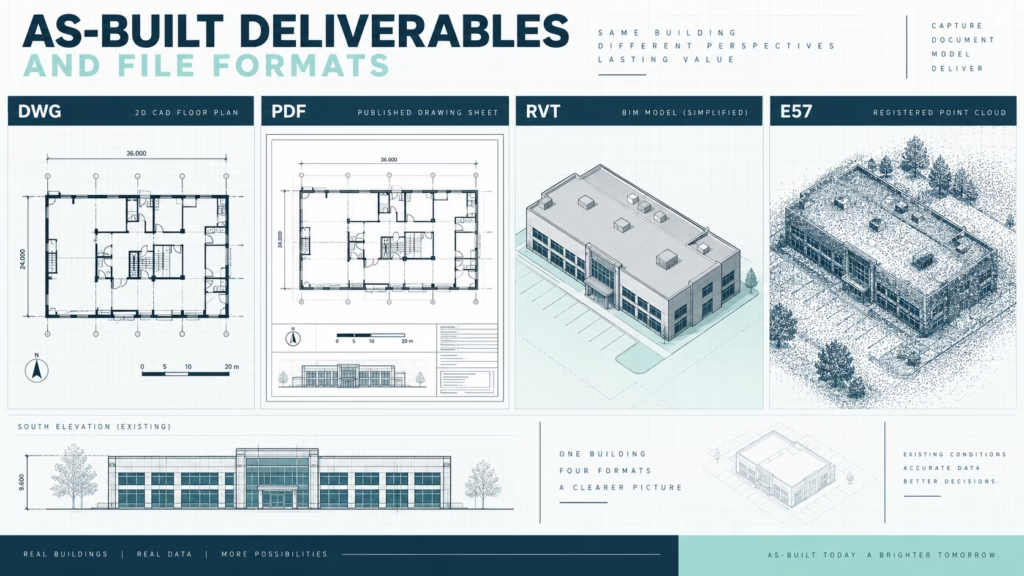
- Deliverables: Specify floor plans, elevations, sections, RCPs, site plans, DWG, PDF, RVT, point cloud, and Revit/BIM requirements explicitly.
- BIM scope: If a model is required, define LOD 100–300 expectations, included elements, exclusions, and Revit version before work starts.
- Quality control: Ask how dimensions, geometry, registration, and drawing/model consistency are reviewed before issue.
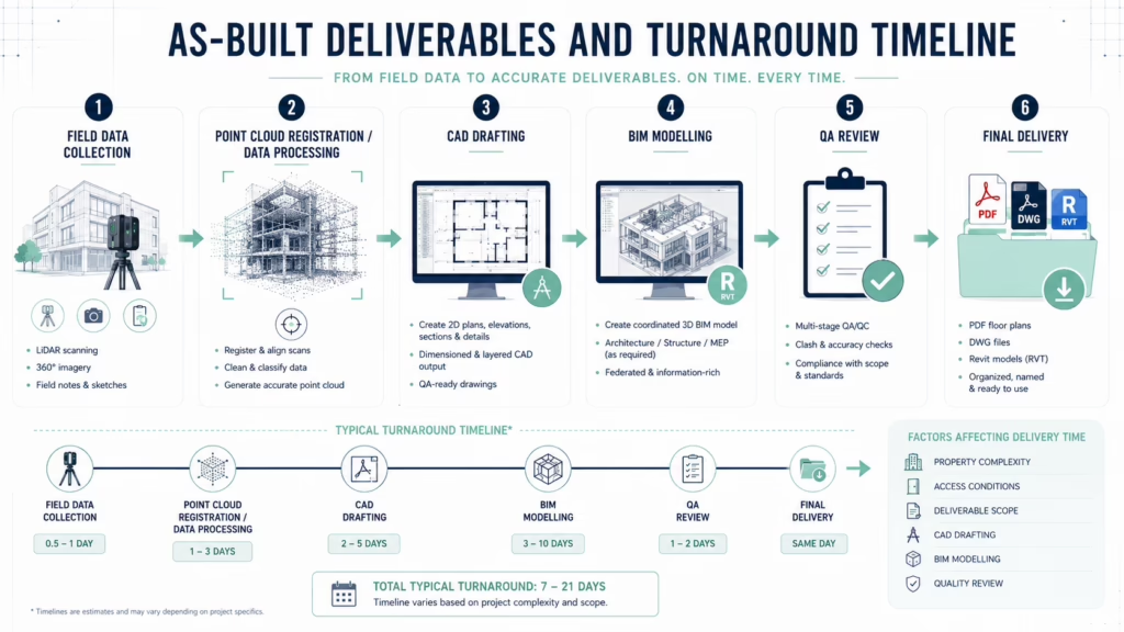
- Schedule: Confirm field access, processing sequence, review milestones, and final delivery timing rather than assuming one standard turnaround.
- Future use: Decide whether the point cloud or model will support only the current renovation or should remain useful for later design and facility decisions.
The MeasureBuilt approach
For Greater Vancouver and the Lower Mainland, MeasureBuilt can structure the workflow as scan → registered point cloud → as-built drawings or Revit/BIM model → DWG, PDF, RVT, and agreed data delivery. Capture and deliverables should match the building, required tolerance, and project decisions.
The scan to BIM vs manual measurement choice should come from the project scope, not from technology preference. Manual measurement is efficient for small, well-defined spaces and selective dimensions. 3D laser scanning is stronger when the project needs broad coverage, complex geometry, reusable point-cloud data, multiple drawing types, or a coordinated Revit/BIM model. Define deliverables, tolerance, site constraints, and revisit risk first. Request a quote at measurebuilt.com/request-a-quote to get a fixed price and timeline for your as-built survey.
FAQ
Is Scan-to-BIM always more accurate than manual measurement?
Not necessarily. Accuracy depends on the full survey workflow, not only the capture technology. Manual measurements can work well for specific dimensions, while laser scanning provides dense coverage for complex geometry. Scanner setup, line of sight, registration, site conditions, and modeling decisions affect the final result, so define the required project tolerance first.
When should I use Scan-to-BIM instead of manual measurement?
Use Scan-to-BIM when the building is large, complex, difficult to revisit, or expected to produce several coordinated deliverables. It is especially useful for point clouds, elevations, sections, RCPs, and Revit/BIM models. Manual measurement is usually more efficient when the scope is small, stable, accessible, and limited to selected dimensions or simple 2D drawings.
What is the main difference between laser scanning vs tape measuring?
The main difference is coverage. Tape measures and laser distance meters capture selected dimensions chosen by the technician. 3D laser scanning captures dense spatial information from visible surfaces and combines it into a registered point cloud. That broader dataset can be measured later and used for CAD drawings, sections, elevations, and BIM modeling.
Is 3D laser scanning cheaper than a manual survey?
Not always. Manual measurement can cost less for a small, simple scope because capture and processing are limited. Scanning may offer better value on larger or more complex buildings because one coordinated dataset can support several deliverables and reduce remobilization risk. Compare total workflow cost, not the survey fee alone.
Do I need a point cloud if I only need floor plans?
Not necessarily. A simple floor plan for a small, regular space can often be produced efficiently from manual measurements. A point cloud becomes more useful when the layout is large or irregular, when additional drawings may be requested later, or when the design team wants a reusable existing-conditions record.
Can Scan-to-BIM produce Revit, DWG, and PDF deliverables?
Yes, when those outputs are included in scope. A registered point cloud can support Revit/BIM geometry and coordinated 2D documentation such as floor plans, elevations, sections, and RCPs. Define required file formats, Revit version, LOD 100–300 expectations, included elements, and drawing content before field capture and modeling.

Analyse this page with AI
Want a summary, fact-check, or an RFP template built around these measurement standards? Send this page directly to your favourite AI model.
Content and prompt will be copied to clipboard for some models.