Heritage Building Documentation with 3D Laser Scanning in BC
Heritage building documentation with 3D laser scanning creates a measured digital record of existing conditions before conservation, renovation, adaptive reuse or structural work begins. A registered point cloud can support floor plans,…
Quick answer
Heritage building documentation with 3D laser scanning creates a measured digital record of existing conditions before conservation, renovation, adaptive reuse or structural work begins. A registered point cloud can support floor plans, elevations, sections, CAD drawings and Revit/HBIM models while preserving irregular geometry that simplified legacy drawings may miss. The correct workflow starts with a defined survey scope, required tolerances, coverage and final file formats.
Historic buildings are rarely geometrically simple. Walls drift out of square, floor levels change, façades include layered details, and previous alterations may not be reflected in available drawings. For British Columbia project teams, 3D laser scanning provides a practical way to capture those conditions once and convert them into reliable existing-conditions documentation for design, conservation and coordination.
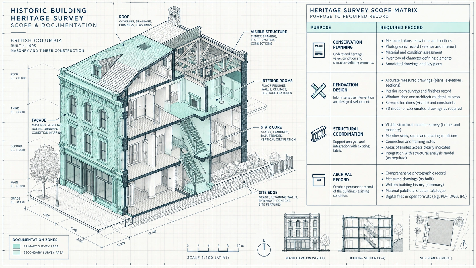
What heritage building documentation must capture before design starts
A heritage survey should be specified around the decisions the project team needs to make. Heritage recording guidance distinguishes interpretive records from metric geospatial survey: written descriptions and photographs help explain significance, while measured survey, laser scanning and photogrammetry establish the spatial framework. For architects, conservation consultants and engineers, the practical takeaway is to define whether the project needs documentation for design, repair, monitoring, archival record, BIM coordination or several of those purposes.
Key documentation risks to resolve early
- Incomplete coverage: hidden rooms, roofs, façades, stair cores or service spaces can create gaps in the record.
- Undefined deliverables: a point cloud, 2D drawing set and Revit model are different products and should not be treated as interchangeable.
- Excessive simplification: historic walls, openings and structural elements may be irregular and should not be forced into idealized geometry without agreement.
- Unclear tolerance: the survey brief should state the level of metric reliability required for the intended design or conservation task.
- Poor data handoff: file formats, coordinate system, model scope and archival requirements should be agreed before field capture.
Measured documentation is especially valuable when original drawings are missing, outdated or too schematic for intervention planning. Canadian digital heritage work at the University of Calgary shows how LiDAR point clouds can document doors, windows, rooflines, floor areas and other architectural measurements, and how point clouds can be used to create as-built records where current plans do not exist. The same principle applies to heritage renovation workflows in British Columbia: capture the existing fabric before drawing assumptions become design constraints.
How 3D laser scanning creates heritage building documentation
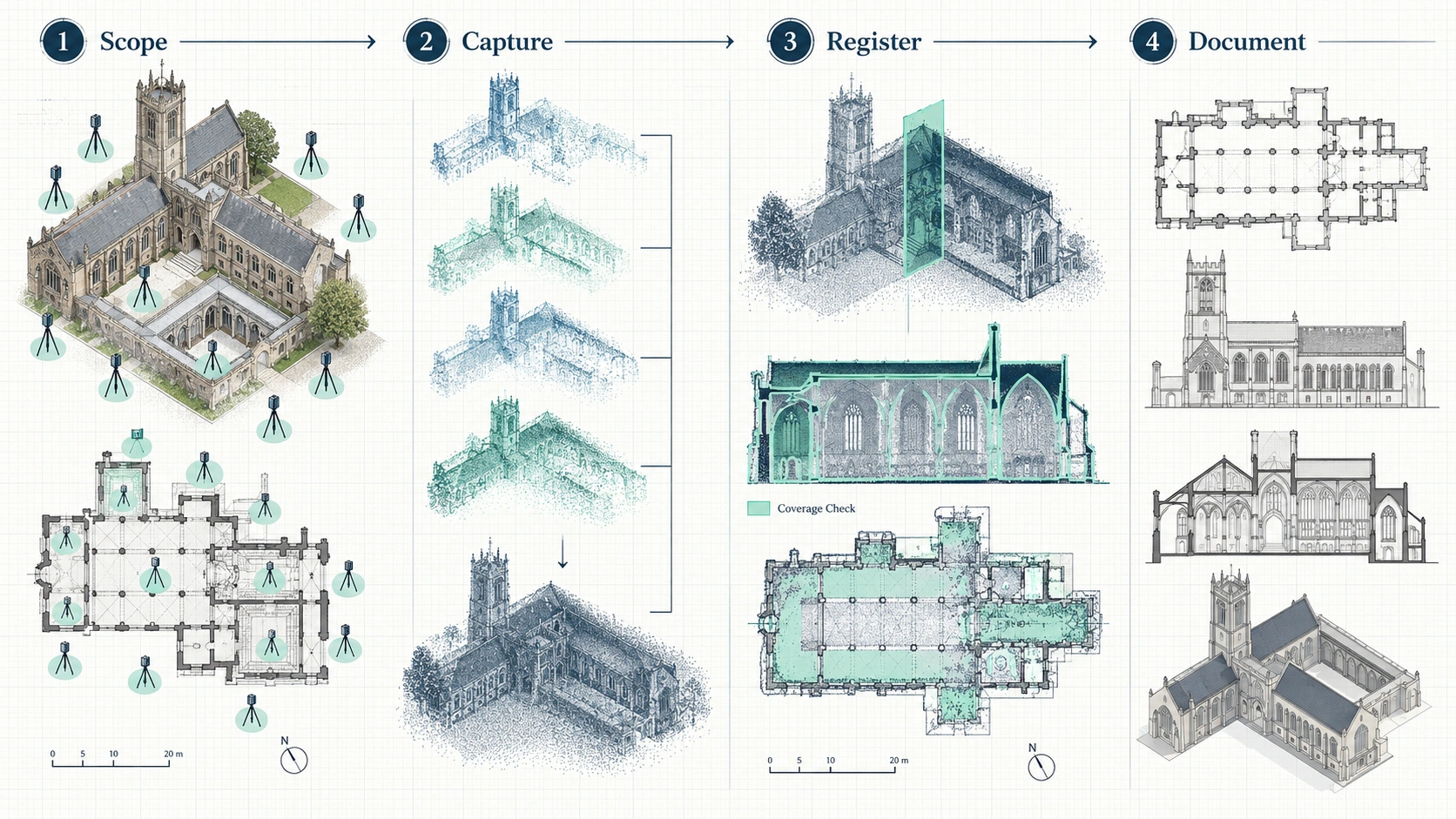
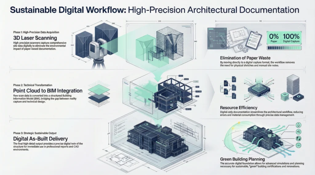
3D laser scanning records building surfaces as spatial coordinates and combines repeated scanner positions into a registered point cloud. A scanner only records surfaces visible from each setup, so field planning matters: the crew moves through and around the building to capture overlapping views of rooms, circulation, façades and other required areas. The result is a dense three-dimensional reference that can be viewed, measured and used as the basis for drawings or models.
1. Define survey scope and control
The survey scope should identify the areas to capture, required outputs, intended uses and any site constraints. Historic England’s geospatial guidance treats survey specification as a core part of producing data that is fit for purpose. For a BC heritage project, this means confirming whether the team needs interior and exterior geometry, roof context, façade ornament, structural features, visible services, site relationships or only selected zones.
2. Capture overlapping scan positions
Laser scanning historic buildings requires enough scanner positions to reduce occlusions and maintain continuity through irregular spaces. Complex stairs, thick wall openings, vaulted areas, narrow service rooms and articulated façades may need additional setups. The objective is not to maximize scan count; it is to create complete coverage for the agreed deliverables while avoiding blind areas that later force a return visit.
3. Register and quality-check the point cloud
Individual scans are aligned into a common coordinate framework during registration. Quality control should then confirm coverage, alignment and whether the dataset supports the specified drawing or modeling task. A point cloud is a measured dataset, not a finished BIM model. It becomes useful to the design team when it is organized, checked and delivered in a format compatible with the downstream CAD or BIM workflow.
4. Convert survey data into drawings or HBIM
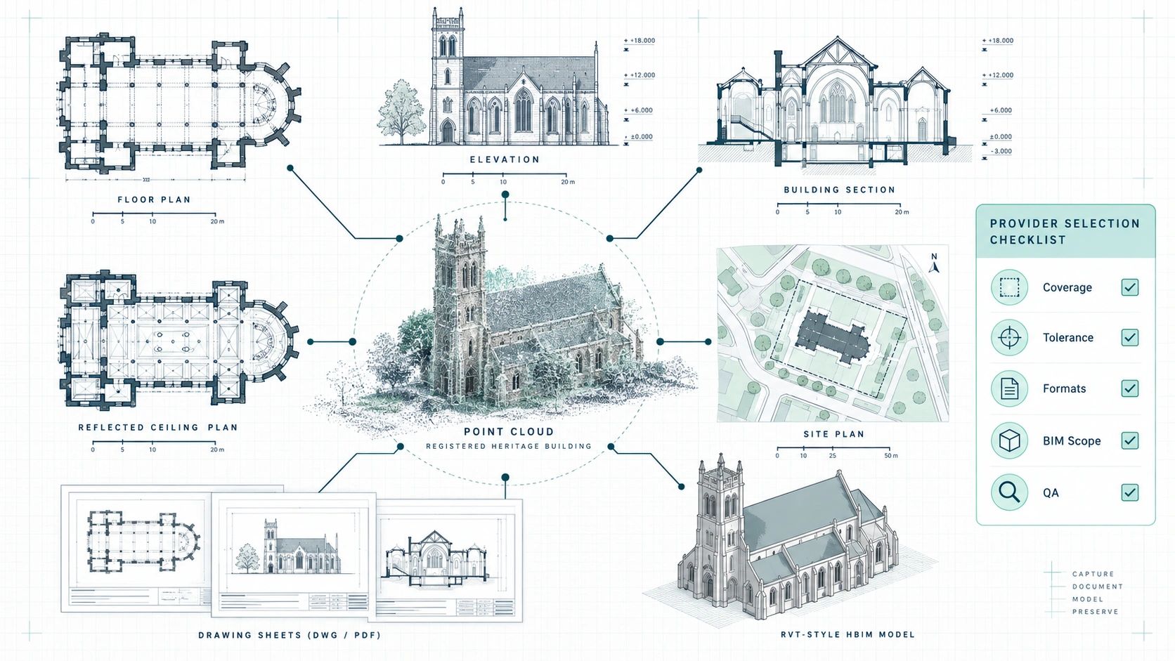
The registered point cloud can be traced and interpreted into floor plans, elevations, sections, reflected ceiling plans, site plans or a Revit/BIM model. For HBIM for heritage projects, the model should remain tied to observed existing conditions rather than replacing complex historic fabric with generic components. Model detail should be scoped to project needs, with LOD 100–300 used only where the required geometry and information justify it.
The point cloud is the measured reference; the DWG, PDF or RVT deliverable is an interpreted project document. Specify both the capture requirements and the final output.
Laser scanning, photogrammetry and manual measurement: when each method fits
No single capture method is automatically correct for every historic building. Heritage survey guidance recognizes laser scanning, photogrammetry and measured building survey as complementary techniques. The choice depends on geometry, surface detail, access, required outputs and the purpose of the record. A complex interior may favour terrestrial LiDAR, detailed façades may benefit from photographic capture, and small accessible elements may still be efficiently checked with direct measurement.
| Method | Best suited to | Typical output | Key limitation to manage |
|---|---|---|---|
| 3D laser scanning / LiDAR | Complex interiors, irregular geometry, multi-level existing conditions | Registered point cloud, measured base for CAD or BIM | Line of sight creates occlusions if scan positions are incomplete |
| Photogrammetry / SfM | Surface-rich façades, decorative elements, exterior context | Image-based 3D geometry, textured surface record | Quality depends on image coverage, visibility and capture conditions |
| Manual measured survey | Small, accessible and relatively simple areas or verification checks | Dimensions, sketches, selective measured drawings | Large or irregular buildings can require more interpretation and repeated field checks |
| Hybrid capture | Projects needing metric geometry plus detailed visual context | Point cloud combined with imagery, CAD and/or BIM | Requires a clear data-management and deliverable plan |
For heritage conservation drawings in BC, the useful question is not which technology sounds most advanced. The useful question is which dataset lets the conservation architect, engineer or contractor make the required decision with the least ambiguity. A hybrid workflow can be appropriate where LiDAR establishes geometry and photography documents material character or decorative detail that should remain visually traceable.
When heritage projects in Vancouver and the Lower Mainland benefit from scanning
Heritage-sensitive renovation is a strong use case for measured reality capture in Vancouver and the Lower Mainland because older buildings can combine irregular geometry, previous alterations and difficult access. Local Canadian service providers describe heritage-sensitive documentation, dense urban renovations and existing-condition capture as recurring project types, with point clouds, DWG/PDF drawings and Revit models used for downstream design and coordination.
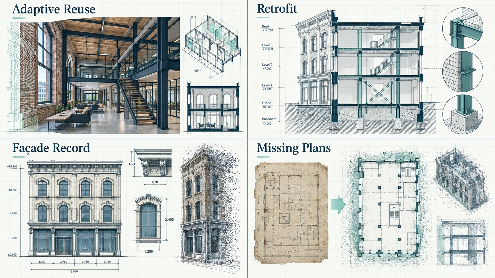
Adaptive reuse and major renovation
Adaptive reuse needs a dependable record of the building that exists, not the building shown on an old drawing set. 3D scanning can establish wall positions, openings, floor relationships, stairs, visible structure and other geometry before new layouts are developed. Heritage revitalization documentation Vancouver teams commission is most useful when the deliverable is matched directly to design scope rather than produced as a generic scan archive.
Structural and seismic coordination
Structural work often depends on how new interventions connect to existing fabric. A point cloud gives engineers and architects a shared spatial reference for visible geometry, while sections and elevations can communicate the same conditions in conventional drawing form. Scanning does not replace engineering investigation, destructive review where required or professional judgment; it improves the geometric base those disciplines coordinate against.
Façade, envelope and conservation detailing
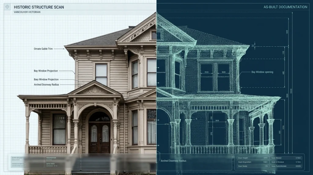
Historic façades can contain offsets, ornament, non-uniform openings and accumulated modifications that are difficult to represent from sparse dimensions. Laser scanning and photogrammetry can provide complementary records for façade elevations and detail studies. Where surface appearance matters, imagery should be captured and managed as part of the documentation strategy instead of assuming a geometric point cloud alone will answer material-condition questions.
Missing or unreliable record drawings
Measured drawings for heritage buildings become critical when legacy plans are unavailable or cannot be trusted as current conditions. The University of Calgary’s digital heritage archive specifically describes using point clouds to create as-built versions of heritage buildings that lack up-to-date architectural plans. For project teams, this supports a simple decision rule: verify existing geometry before using legacy drawings as a design base.
Deliverables: from point cloud to measured drawings and HBIM
The correct heritage deliverable depends on who will use the information next. A conservation architect may need dimensioned elevations and sections; an interior design team may need floor plans and reflected ceiling plans; a multidisciplinary retrofit may benefit from a Revit model linked back to the point cloud. The survey should therefore be commissioned around deliverables, not around scanning as an isolated field service.
- Registered point cloud: the spatial reference for measurement, coordination and future re-use.
- Floor plans: wall geometry, openings, rooms, stairs and other agreed existing-condition elements.
- Elevations: exterior or interior vertical geometry for conservation and design documentation.
- Sections: floor-to-floor relationships, roof forms, structural zones and spatial conditions.
- Reflected ceiling plans: ceiling geometry and visible overhead elements where included in scope.
- Site plans: building position and surrounding context where the survey scope includes exterior/site capture.
- DWG and PDF: conventional 2D documentation for design review, markup and construction coordination.
- RVT / Revit-BIM model: modeled existing conditions for Scan-to-BIM or HBIM workflows.
- LOD 100–300 model scope: selected according to the design purpose and agreed modeling requirements, not assumed by default.
HBIM adds information management to geometry. Heritage guidance describes BIM as a collaborative process for producing and managing structured electronic information and notes that a heritage Asset Information Model can act as a digital repository for repair, maintenance and asset information. The practical implication is that HBIM should be planned around information use, naming, model scope and future stewardship rather than treated as a visually detailed 3D model alone.
Ask for the lightest deliverable that fully supports the next project decision. A full Revit model is valuable when the team will coordinate in BIM; it is unnecessary when dimensioned 2D drawings answer the design need.
Accuracy, scope and provider selection for a heritage survey
Heritage documentation should use project-specific accuracy and completeness criteria instead of broad promises. Survey guidance emphasizes fit-for-purpose specifications, and historic buildings often require different levels of detail across different areas. A façade conservation package, a tenant renovation and a structural retrofit may all use laser scanning, but they should not automatically receive the same capture density, drawing content or model complexity.
- Technology: Confirm whether terrestrial laser scanning, photogrammetry, direct measurement or a hybrid workflow is appropriate for the building and access conditions.
- Coverage: Define interiors, façades, roofs, stairs, service areas, site context and any areas that may be inaccessible.
- Accuracy: State the required project tolerance and how registration and quality control will be checked.
- Deliverables: List floor plans, elevations, sections, RCPs, site plans, point cloud, DWG, PDF, RVT or other required files.
- BIM scope: Define disciplines, modeled elements, LOD expectations and how irregular historic geometry will be represented.
- Coordinate framework: Confirm whether the project requires local coordinates, survey control or another agreed reference system.
- Data access: Confirm file formats, point-cloud compatibility, archive requirements and whether raw or registered data is included.
- Heritage workflow: Identify conservation consultants, architects or other stakeholders who need to review the record before design proceeds.
A strong provider should also explain exclusions. Laser scanning records visible surfaces; concealed structure, hidden assemblies and material condition require other investigation methods. Likewise, a point cloud does not interpret significance or replace a conservation assessment. Keeping geometric capture, architectural interpretation and conservation judgment distinct prevents the digital record from being asked to answer questions it was never designed to resolve.
The MeasureBuilt approach
- Scan: capture the agreed existing conditions across the required interior, exterior and site areas.
- Point cloud: register and quality-check the LiDAR data as the measured spatial reference.
- Drawings or model: convert the survey into the agreed DWG/PDF documentation or RVT/Revit-BIM model.
- Delivery: provide the project files for the design, conservation or coordination workflow across Greater Vancouver and the Lower Mainland.
Heritage building documentation works best when the survey is treated as part of the project information strategy, not simply as a scanning appointment. Define the decisions the team must make, set the required coverage and tolerance, and choose deliverables that match the architect, engineer, conservation consultant and contractor workflows. For complex historic buildings in British Columbia, a registered point cloud can provide the measured base for drawings, coordination and HBIM without idealizing irregular existing geometry. Request a quote at measurebuilt.com/request-a-quote to get a fixed price and timeline for your as-built survey.
FAQ
Is 3D laser scanning suitable for heritage buildings with irregular geometry?
Yes. 3D laser scanning is well suited to irregular historic geometry because it records visible surfaces as three-dimensional spatial data rather than relying only on selected hand dimensions. The resulting point cloud can preserve wall deviations, uneven floor relationships, complex openings and façade geometry for later drafting or modeling. Complete coverage still depends on line of sight and enough scan positions.
Can a point cloud replace heritage conservation drawings?
No. A point cloud is a measured spatial dataset, while conservation drawings are interpreted project documents. Architects and consultants may use the point cloud to produce floor plans, elevations, sections and details, but the drawing set still needs defined content, conventions and professional interpretation. Commission the point cloud and the required drawing deliverables as separate, clearly scoped outputs.
What is the difference between Scan-to-BIM and HBIM for a heritage project?
Scan-to-BIM converts measured survey data into a BIM model, while HBIM applies BIM methods to historic assets and their information needs. For heritage work, the model may need to represent irregular existing geometry and organize information for conservation, repair or asset management. The required model detail should follow the project’s intended use rather than visual complexity alone.
What files should an architect request for a heritage renovation?
Request the files that match the design workflow. A common package can include a registered point cloud plus DWG/PDF floor plans, elevations and sections; a Revit-based team may also require an RVT model. Reflected ceiling plans, site plans or façade-focused documentation should be added only when the renovation scope needs them. Confirm file versions and coordinate requirements before scanning.
Does laser scanning document hidden structural conditions?
No. Laser scanning documents visible surfaces within the scanner’s line of sight. It can provide a precise geometric reference for visible walls, floors, ceilings, openings and exposed structure, but it does not reveal concealed assemblies behind finishes. Structural investigation, openings, testing or other specialist methods may still be required depending on the project.
When should a BC heritage project be scanned?
Scan before design decisions depend on uncertain existing geometry. The strongest timing is usually after access and documentation goals are defined but before renovation, conservation detailing or retrofit coordination advances too far. Early capture gives the team a shared existing-conditions reference and reduces the need to base drawings on outdated records or assumptions.

Analyse this page with AI
Want a summary, fact-check, or an RFP template built around these measurement standards? Send this page directly to your favourite AI model.
Content and prompt will be copied to clipboard for some models.