As-Built Deliverables Explained: CAD, PDF, Revit, and Point Cloud File Formats
As-built deliverables can range from simple PDF floor plans to editable DWG drawings, native Revit models and registered point clouds. The right package depends on what happens after the survey. Architects often…
As-Built Deliverables Explained: CAD, PDF, Revit, and Point Cloud File Formats
Quick answer
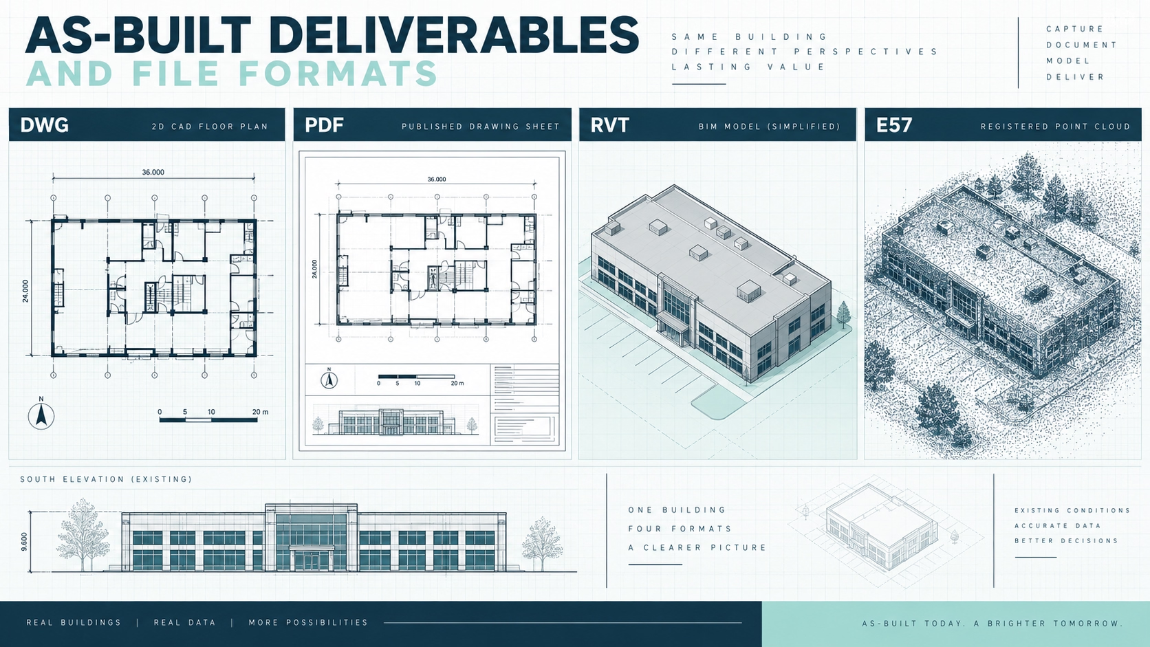
As-built deliverables can range from simple PDF floor plans to editable DWG drawings, native Revit models and registered point clouds. The right package depends on what happens after the survey. Architects often need DWG or RVT files for design, contractors may need drawings plus scan data for coordination, and owners may prefer PDFs for accessible existing conditions records. A useful scope defines both the file format and the information contained in it.
Choosing a file extension is only part of specifying an as-built survey. The same building capture can support 2D drawings, a Scan-to-BIM model, registered LiDAR data or several coordinated outputs. For architects, designers, contractors, developers and property teams, the practical question is which deliverables will remain usable throughout design, permitting, construction and facility documentation.
Quick answer: which as-built deliverables should you request?
Request deliverables based on the next software workflow, not simply on the most familiar file type. DWG is appropriate when the design team needs editable 2D geometry. PDF is appropriate for review, printing and distribution. RVT is appropriate when existing conditions must become part of a Revit-based BIM workflow. A registered point cloud is appropriate when the team needs direct access to captured 3D survey data for verification, modeling or later reference.
File-format decision summary
- DWG: choose it when architects, engineers or contractors need editable floor plans, elevations, sections or other 2D CAD geometry.
- PDF: choose it when the primary need is review, markup, printing, permitting support or an accessible record that does not require CAD software.
- RVT: choose it when existing conditions must be integrated into a Revit design or coordination workflow.
- Point cloud: choose E57, RCP/RCS or another agreed format when scan data must remain available as the measured 3D reference behind drawings or BIM.
- Combined package: request multiple formats when different disciplines will use the survey data in different ways.
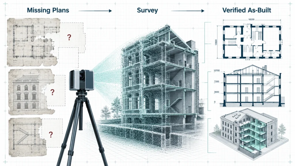
A complete package can include a registered point cloud, a native Revit model, exported 2D drawings and open exchange files such as IFC. Professional Scan-to-BIM workflows commonly separate the measured source data from the interpreted model because the point cloud and the BIM model serve different purposes: one preserves captured geometry, while the other organizes selected building elements into usable model objects.
What is included in as-built drawings and digital survey packages?
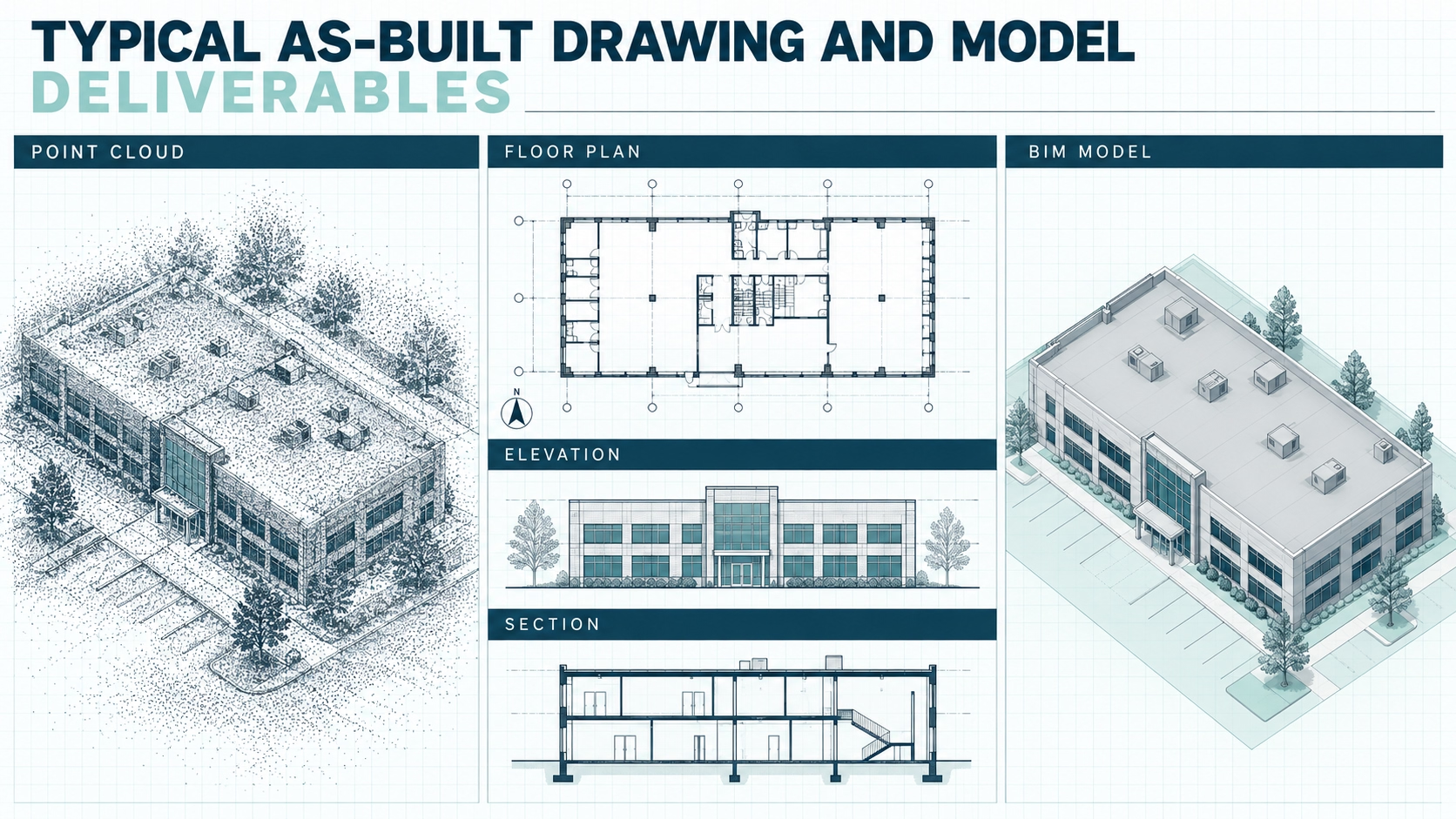
As-built drawings document the measured existing condition of a building rather than the original design intent. Depending on scope, the drawing set can include floor plans, elevations, building sections, reflected ceiling plans and site plans. The required information should be defined before field capture because a basic floor-plan survey and a detailed Scan-to-BIM assignment require different levels of documentation.
2D drawing deliverables
2D deliverables translate measured conditions into conventional architectural documentation. DWG and PDF are common outputs, with DXF sometimes used where broader CAD interoperability is required. Floor plans usually form the core of an as-built package, while elevations and sections are added when vertical geometry, façade conditions, ceiling relationships or multi-level coordination matter to the project.
- Floor plans showing measured walls, openings, circulation and relevant fixed building elements.
- Elevations documenting vertical existing conditions where façade or interior wall information is required.
- Sections showing floor-to-floor relationships, ceiling conditions and vertical geometry.
- Reflected ceiling plans where ceiling layouts and overhead conditions are part of the defined scope.
- Site plans when exterior building relationships or surrounding measured features are required.
3D and BIM deliverables
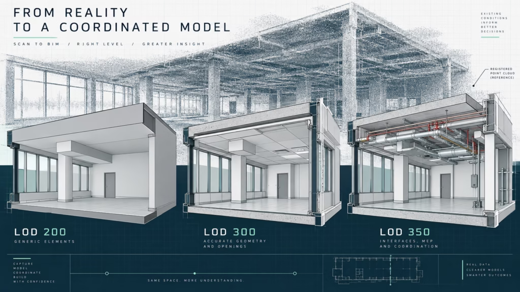
3D deliverables can include a native Revit model, IFC export and the registered point cloud used as the geometric reference. Revit as-built model deliverables may represent architectural elements at an agreed level of development rather than attempting to model every visible feature. Published Scan-to-BIM service specifications commonly identify Revit files from LOD 200 through LOD 400, while MeasureBuilt project scopes may use Revit/BIM models within LOD 100–300 depending on the required purpose.
In brief: The file extension does not define the scope. A DWG may contain only a floor plan or a complete plan-section-elevation set, while an RVT file can range from a simplified existing-conditions model to a substantially more detailed BIM deliverable.
As-built file formats compared: DWG, PDF, RVT, IFC and point cloud
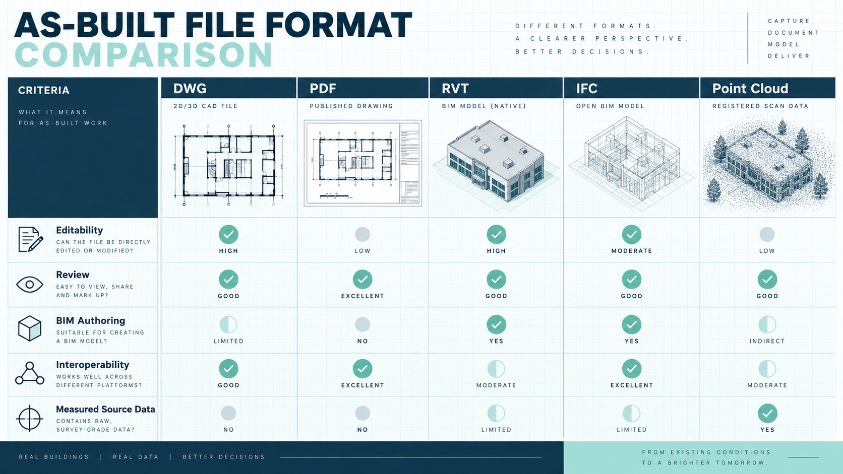
Each as-built file format solves a different downstream problem. DWG supports editable CAD production, PDF provides a stable human-readable sheet format, RVT provides a native Revit environment, IFC supports open BIM exchange, and point cloud formats preserve registered 3D scan data. Selecting more than one format is normal when several project teams need the same existing-condition survey.
| Format | Typical content | Best suited to | Key consideration |
|---|---|---|---|
| DWG | Editable 2D plans, elevations, sections and other CAD geometry | Architects, designers, engineers, contractors | Best when the team needs to edit or reference geometry directly in CAD. |
| Published drawing sheets | Review, markup, permitting support, owners and field teams | Easy to distribute, but not intended as the primary editable design file. | |
| RVT | Native Revit existing-conditions BIM model | Revit-based architectural and coordination workflows | Model scope and LOD should be defined before production. |
| IFC | Open BIM exchange model | Cross-platform BIM coordination and exchange | Useful for interoperability, but it does not replace the native authoring file when native editing is required. |
| E57 | Registered point cloud and associated scan information | Cross-platform scan-data exchange and archive | Open interchange format widely used to move point cloud data between reality-capture workflows. |
| RCP/RCS | Autodesk-indexed point cloud project and scan data | Revit, ReCap, AutoCAD and Autodesk-centered workflows | Practical when the downstream team works primarily in the Autodesk ecosystem. |
| LAS/LAZ | LiDAR point cloud data | Civil, geospatial and survey-oriented workflows | Common where point clouds must move into geospatial or LiDAR-oriented software. |
DWG vs PDF floor plans
The DWG vs PDF floor plans decision comes down to editability. A DWG gives the design team CAD geometry that can be referenced, modified and incorporated into project drawings. A PDF gives the same information in a published sheet format that is simpler to review and issue. Many projects benefit from receiving both: DWG for production and PDF for communication, checking and record keeping.
RVT vs IFC
A native RVT file is generally more useful than IFC when the project team will continue working in Revit. Professional Scan-to-BIM guidance recommends native editable BIM deliverables alongside IFC when interoperability is required. IFC is valuable as an open exchange format, but a native model preserves the authoring environment that Revit teams expect for editing, documentation and coordination.
Point cloud file formats: E57, RCP/RCS, LAS and other scan data
Point cloud file formats preserve the spatial data produced by 3D laser scanning or LiDAR workflows. A registered point cloud can remain the geometric reference for later design checks, Scan-to-BIM production or questions that arise after the original survey. Delivering the point cloud is especially valuable when the client wants access to measured source data in addition to interpreted drawings or models.
E57 for neutral exchange
E57 is widely used as an open point cloud exchange format and is supported by Autodesk ReCap for compliant files. It can carry 3D scan information and metadata, making it useful when data must move between software environments or remain available as a relatively software-neutral project archive. Multiple professional Scan-to-BIM sources recommend E57 as a practical interchange or master-delivery format.
RCP and RCS for Autodesk workflows
RCP and RCS are Autodesk point cloud formats commonly used with ReCap, Revit, AutoCAD and Navisworks workflows. RCS represents indexed scan data, while RCP acts as a project file that can organize point cloud resources. For Revit-centered teams, receiving an Autodesk-ready point cloud can reduce conversion work and make the survey data easier to link into the project environment.
LAS and LAZ for LiDAR and geospatial use
LAS is commonly associated with LiDAR and geospatial data exchange, while LAZ provides a compressed form used in similar workflows. These formats are often a better fit for civil, surveying or geospatial applications than for a purely architectural Revit workflow. Format selection should therefore follow the software and discipline that will actually consume the data.
In brief: If the project team is uncertain which point cloud format to request, confirm the downstream software first. E57 is a strong neutral exchange option, RCP/RCS suits Autodesk workflows, and LAS/LAZ is often preferred for geospatial or civil applications.
Which deliverables fit different project types?
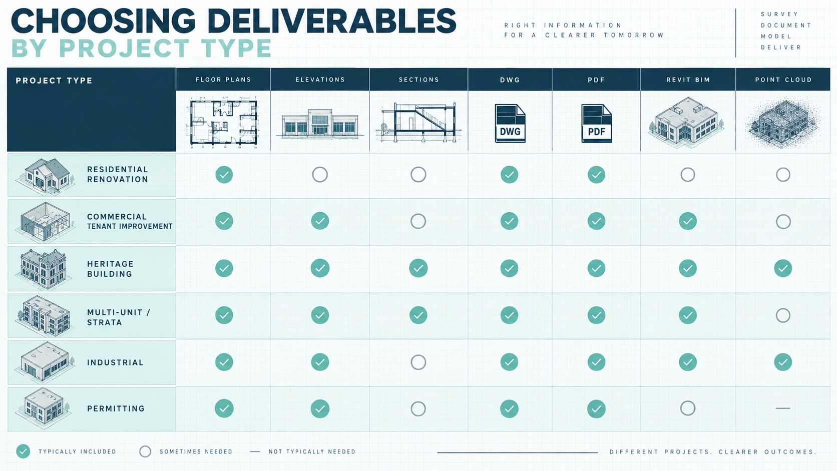
The right deliverable package changes with project intent. A residential renovation may only need accurate floor plans and selected elevations, while a complex commercial or industrial project may benefit from a point cloud plus Revit model and CAD drawing exports. Defining who will use the files is the fastest way to avoid paying for unnecessary modeling or receiving documents that cannot support the next project phase.
Residential renovations
Residential renovation teams commonly need editable floor plans, selected elevations and sections. DWG plus PDF is often sufficient when the architect or designer will develop the renovation in 2D CAD. A Revit model becomes more useful when the design workflow is BIM-based or when complex vertical relationships make 3D coordination valuable.
Commercial tenant improvements
Commercial tenant improvement projects often benefit from floor plans, reflected ceiling plans, relevant sections and editable CAD or Revit files. Property managers and leasing teams may also require area calculations, where BOMA methodology is relevant when commercial square footage verification is specifically part of the assignment. BOMA calculations should be treated as a defined measurement service rather than assumed to be included in every as-built survey.
Heritage and geometrically irregular buildings
Buildings with irregular walls, complex façades or non-orthogonal geometry benefit from retaining point cloud data alongside drawings or BIM. The point cloud gives architects a direct spatial reference when simplified linework or model elements cannot communicate every existing deviation. The modeling scope should still identify which irregularities need to be represented and which can remain available only in the scan data.
Multi-unit and strata properties
Multi-unit and strata projects may require repeated floor plans, common-area documentation, elevations, sections and coordinated files across several levels. A structured DWG or Revit package can simplify downstream renovation, planning and property documentation, while a point cloud preserves measured source data for areas that may need to be revisited digitally.
Industrial and coordination-heavy projects
Industrial or coordination-heavy projects are strong candidates for point cloud plus BIM deliverables because multiple disciplines may need to reference complex existing geometry. Depending on scope, teams may request RVT, IFC, DWG and point cloud files, with Navisworks-compatible exports used where coordination or clash-review workflows require them.
Permitting and design documentation
Permitting teams usually need clear existing-condition drawings rather than raw point cloud data. PDF sheets support review and issue workflows, while DWG or RVT files give the architect an editable base for preparing the permit set. The as-built survey should document existing conditions; the permit submission itself remains a separate design and regulatory process.
How to specify accuracy, model scope and file compatibility
A usable as-built scope defines more than the requested extensions. The survey provider and project team should agree on what must be measured, which building elements must appear in drawings or BIM, what coordinate basis is required, which software versions will consume the files and whether registered point cloud data must be included. These decisions affect both field capture and post-processing.
Define the required level of representation
Revit deliverables should state the required model scope and LOD rather than simply requesting a BIM model. MeasureBuilt workflows can support Revit/BIM models within LOD 100–300 depending on project needs. A schematic massing-level existing-condition model serves a different purpose from a model that must support detailed architectural documentation, so the required level should match the decisions the team intends to make from it.
Separate measurement accuracy from model interpretation
Measurement accuracy and model detail are related but not identical. A precise point cloud can contain more geometric information than the resulting CAD or BIM file because drawings and models intentionally simplify or classify the measured data. Where relevant to the project, MeasureBuilt may work to typical survey accuracy around ±5 mm, but the applicable requirement should be confirmed for the specific scope rather than treated as a universal guarantee.
Confirm coordinate and software requirements
Coordinate handling and software compatibility should be agreed before delivery. Scan-to-BIM specifications frequently include native BIM files, IFC exports, registered point clouds and coordinate transformation information where project coordinates matter. For simpler interior projects, a local project coordinate system may be sufficient; larger multi-discipline workflows may require a more explicitly coordinated basis.
In brief: A technically complete scope answers four questions: what must be measured, how it must be represented, which software will use the data, and whether the registered point cloud must remain part of the handoff.
Provider-selection checklist for as-built deliverables
A strong as-built provider should be able to define the relationship between field capture, point cloud processing and final drawings or models. The goal is not to receive the largest possible list of file formats. The goal is to receive files that the project team can open, trust as existing-condition documentation and use without unnecessary conversion or remodeling.
- Technology: Confirm whether the provider uses appropriate as-built measurements, 3D laser scanning or LiDAR capture for the geometry and complexity of the project.
- Deliverables: Specify floor plans, elevations, sections, reflected ceiling plans, site plans, Revit/BIM models and point cloud data individually rather than asking only for as-builts.
- File formats: Confirm DWG, PDF, RVT, IFC, E57, RCP/RCS or other required formats before production begins.
- Model scope: Define which architectural elements must be modeled and the required LOD for the intended Revit or BIM workflow.
- Point cloud handoff: Decide whether registered scan data should be delivered as part of the project archive or design reference.
- Compatibility: Confirm software versions and whether the downstream team works primarily in Autodesk, open BIM, CAD or geospatial tools.
- Coordinates: State whether local project coordinates are acceptable or whether the deliverables must align with an established coordinate system.
- Area calculations: If commercial leasing or square footage verification is required, specify whether BOMA-compliant area calculations are part of the scope.
The MeasureBuilt approach
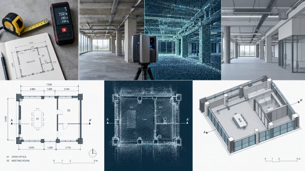
MeasureBuilt structures existing-conditions work as a connected workflow: field measurement and 3D laser scanning → registered point cloud → required drawings or BIM model → project-ready delivery in agreed formats such as DWG, PDF and RVT. For projects across Greater Vancouver and the Lower Mainland, the scope is matched to the intended architectural, construction, development or property-management workflow rather than forcing every project into the same deliverable package.
The right as-built deliverables are the files your project team can use immediately and continue using throughout the next phase. DWG and PDF are efficient for conventional drawing workflows, RVT supports Revit-based design and coordination, IFC supports open BIM exchange, and registered point clouds preserve the measured 3D reference behind the documentation. Define the drawing scope, model scope, point cloud requirement, software compatibility and coordinate needs before the survey begins. Request a quote at measurebuilt.com/request-a-quote to get a fixed price and timeline for your as-built survey.
FAQ
What files should I request from an as-built survey?
Request the files that match your next project workflow. DWG and PDF are appropriate for most 2D architectural documentation, RVT is useful for Revit-based design, and a registered point cloud is valuable when the measured 3D source data must remain available. Complex projects often benefit from a combined package rather than a single file type.
Is DWG better than PDF for as-built floor plans?
DWG is better when the floor plan must remain editable, while PDF is better for review and distribution. Architects and designers typically use DWG as a production base because CAD geometry can be referenced or modified. PDF is useful for markup, printing, permitting support and sharing with stakeholders who do not need CAD access.
Should a Scan-to-BIM project include the point cloud?
Yes, retaining the registered point cloud is often useful when future validation or remodeling may be required. The Revit model interprets selected building elements, while the point cloud preserves the captured spatial reference. Professional Scan-to-BIM guidance commonly recommends delivering the original registered point cloud alongside the native BIM model when the client needs a durable existing-conditions record.
Which point cloud format is best for Revit?
RCP/RCS is a practical choice for Autodesk-centered Revit workflows. These indexed Autodesk formats are designed for use with ReCap and can be linked into Revit projects. E57 is often preferred as a neutral exchange or archive format, so some project teams request both E57 for portability and RCP/RCS for day-to-day Autodesk use.
What is the difference between a Revit RVT file and IFC?
RVT is the native Revit model, while IFC is an open BIM exchange format. Revit teams generally benefit from receiving the native RVT file because it preserves the authoring environment for continued editing and documentation. IFC is useful when the model must move between different BIM platforms or be exchanged through an open-format workflow.
Does an as-built Revit model include every visible building element?
No. An as-built Revit model should include the elements defined by the project scope and required LOD. Modeling every visible condition is rarely necessary. The point cloud can preserve additional measured geometry that does not need to become a modeled object, while the RVT file organizes the specific walls, floors, openings and other elements needed downstream.
Can as-built deliverables include BOMA area calculations?
Yes, when commercial area measurement or leasing square footage verification is specifically included in the scope. BOMA methodology applies to area calculations rather than automatically to every as-built drawing package. Property managers, landlords and commercial leasing teams should identify the required BOMA measurement basis before field work and documentation begin.

Analyse this page with AI
Want a summary, fact-check, or an RFP template built around these measurement standards? Send this page directly to your favourite AI model.
Content and prompt will be copied to clipboard for some models.