Renovating Without Original Drawings: A Practical Guide
If you have missing building plans, do not start design by guessing dimensions from old sketches, listing floor plans, or partial records. First search available archives and owner files, then verify whether…
Quick answer
If you have missing building plans, do not start design by guessing dimensions from old sketches, listing floor plans, or partial records. First search available archives and owner files, then verify whether those documents match the building. If they do not, commission an as-built survey to capture current conditions and produce the floor plans, elevations, sections, CAD files, Revit model, or point cloud your project actually needs.
Renovation teams often inherit a building with incomplete records, no original blueprints for renovation, or drawings that no longer match the site. The practical response is to treat old documents as reference material, define the required level of documentation, and create a verified existing-conditions base before design decisions depend on geometry that may be wrong.
What missing building plans mean for a renovation
Missing drawings are a documentation problem, not a reason to design from assumptions. A renovation requires a trustworthy description of what is physically present: wall locations, openings, levels, columns, ceilings, stairs, structural offsets, and other features that affect the scope. Old plans can still be useful for orientation, but their age does not prove that the building was constructed exactly as drawn or remained unchanged afterward. Professional guidance on existing-building work specifically warns against accepting old plans without checking their completeness, plausibility, and suitability for the current project.)
Key decision before design starts
- Risk: The team may design against geometry that never existed or has changed through previous renovations.
- Decision: Determine whether existing records can be verified or whether a new measured survey is required.
- Scope: Capture only the information needed for the renovation, permitting, coordination, or facilities objective.
- Output: Specify the required floor plans, elevations, sections, reflected ceiling plans, site plans, DWG, PDF, RVT, Revit/BIM model, or point cloud before fieldwork begins.
A drawing set is valuable only when the project team knows what it represents. If the current building cannot be verified from reliable records, create a new existing-conditions baseline before detailed design.
How to deal with missing building plans before design starts
Separate document recovery from geometric verification. Historical drawings may reveal structural intent, previous permit work, or original layouts, but finding a drawing does not automatically make it suitable for renovation. When the building condition is uncertain, a measured survey captures current geometry from scratch.
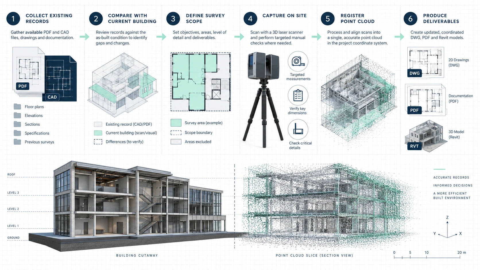
- Collect what exists: owner files, previous permit sets, landlord or property-management records, consultant PDFs, old CAD files, renovation markups, and facility documents.
- Review the records for consistency: compare room arrangement, exterior openings, stair positions, column grids, floor levels, and obvious additions against the current building.
- Classify the drawings: identify which sheets are design drawings, permit drawings, shop drawings, redlines, or actual as-built records. These document types answer different questions.
- Define the renovation information requirement: decide which spaces, floors, facades, ceiling zones, exterior areas, and interfaces must be documented.
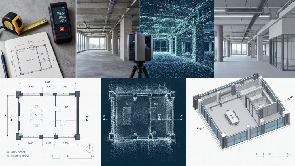
- Choose the capture method: manual measurement may suit limited simple spaces; 3D laser scanning is often more efficient for larger, irregular, congested, or highly coordinated environments; a hybrid approach can combine both.
- Produce the working base: convert verified field data into drawings or a BIM model in the formats required by the architect, designer, contractor, developer, property manager, or permitting team.
- Run a coordination check before design progresses: confirm levels, major dimensions, openings, and other project-critical geometry against the point cloud or field record.
If the goal is how to get drawings of an existing building, archives can provide context while a new survey provides current geometry. Use both when helpful, and distinguish historical information from observed field conditions.
Manual measurement, 3D laser scanning, or a hybrid survey
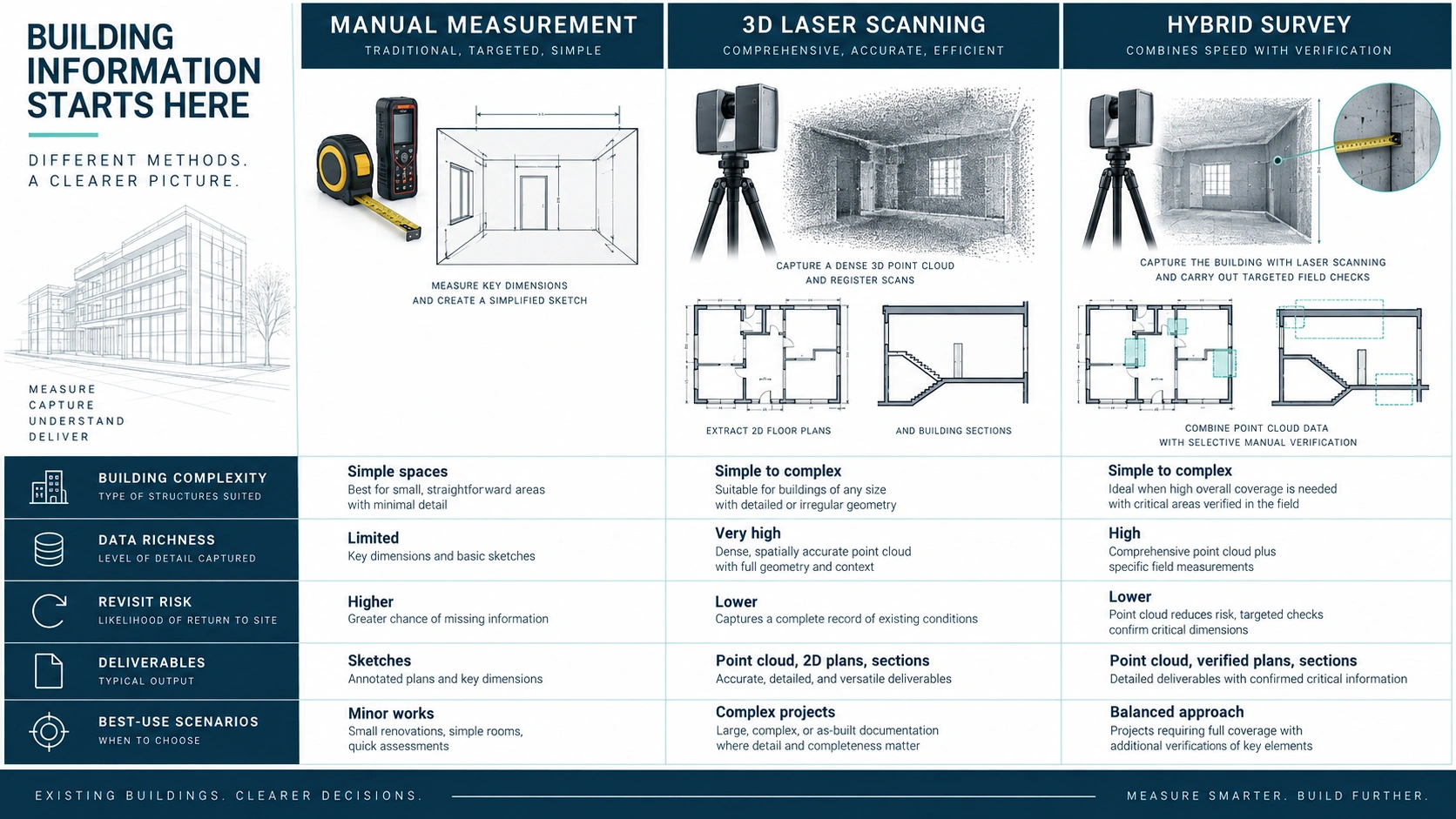
The capture method should follow building complexity and deliverable requirements, not technology preference. Manual measurement can be effective for a small, accessible room or a straightforward residential area. 3D laser scanning captures dense spatial observations that can be registered into a point cloud, giving the production team a reusable geometric reference for drawings and Scan-to-BIM. A hybrid survey adds targeted manual checks or other field methods where scanning alone does not answer the project question.
| Method | Best suited to | Typical output | Main limitation |
|---|---|---|---|
| Manual measurement | Small or simple areas with limited geometry | Dimensions, sketches, CAD floor plans | More dependent on what is selected and measured during the site visit |
| 3D laser scanning / LiDAR | Complex buildings, irregular geometry, multiple rooms, coordination-heavy renovations | Registered point cloud, CAD drawings, Revit/BIM model | Requires processing and a defined modeling or drafting scope |
| Hybrid survey | Projects with mixed conditions or special verification needs | Point cloud plus targeted checks and project-specific notes | Scope must clearly define which features are captured by which method |
| Existing drawings only | Early reference when documents are known to be current and reliable | Existing CAD/PDF set | Not appropriate as the sole geometric basis when site conditions are uncertain |
Why point clouds help when geometry is uncertain
A registered point cloud preserves a dense digital record of visible surfaces captured during scanning. That makes it useful when a designer later needs a dimension, section cut, ceiling relationship, or facade reference that was not obvious during the site visit. RICS guidance treats point clouds, CAD, BIM, floor plans, reflected ceiling plans, cross-sections, and elevations as distinct survey outputs that should be specified according to client requirements.
Use manual measurement when the geometry and scope are simple. Use 3D laser scanning when the cost of returning to site, missing spatial relationships, or coordinating complex existing conditions is higher than the value of a minimal survey.
When current existing-conditions documentation is necessary
A new survey is most important when design, pricing, fabrication, permitting, or coordination depends on dimensions that cannot be trusted from the available record. The required detail varies by project type; capture the features that could change a design decision.
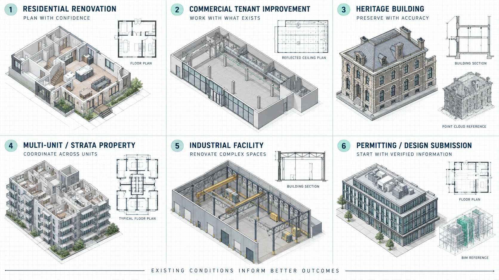
Residential renovations
Residential work often needs verified floor plans, exterior openings, wall geometry, stairs, ceiling heights, and the interfaces around additions or structural changes. For older houses, the task may be to recreate floor plans of an old building from current conditions rather than redraw an original plan that no longer reflects the property.
Commercial tenant improvements
Tenant-improvement teams typically need a dependable base for space planning, partitions, ceiling coordination, millwork, mechanical and electrical interfaces, and contractor pricing. Reflected ceiling plans and sections can become more important than a floor plan alone when ceiling systems and services drive the design.
Heritage and irregular buildings
Heritage and older buildings frequently contain non-orthogonal walls, uneven levels, later additions, and details that are difficult to describe with a few tape dimensions. Case documentation from older-building surveys shows why full 3D capture can be useful where reliable plans are absent and renovation must be based on current geometry. ([Pointcab][3])
Multi-unit, strata, and property-management projects
Multi-unit properties may need consistent plans across repeated units, common areas, service spaces, and circulation. Define whether the scope covers representative units, every unit, common property, exterior elevations, or only renovation zones.
Industrial and contractor-led renovations
Industrial projects may require sections, equipment interfaces, levels, structural geometry, and clearances. A point cloud is especially useful when several disciplines need the same existing-condition reference.
Permitting and design submissions
Permit requirements vary by authority and project, so an as-built survey should not be described as a permit approval by itself. Its role is to provide the design team with a reliable existing-condition base from which the required permit drawings can be prepared.
What existing conditions documentation should include
Existing conditions documentation should be scoped around the decisions the project team must make. RICS measured-building guidance lists outputs such as floor plans, roof plans, reflected ceiling plans, cross-sections, elevations, 3D models, BIM, and registered point clouds, reinforcing the need to define deliverables before field capture rather than treating every survey as the same product.
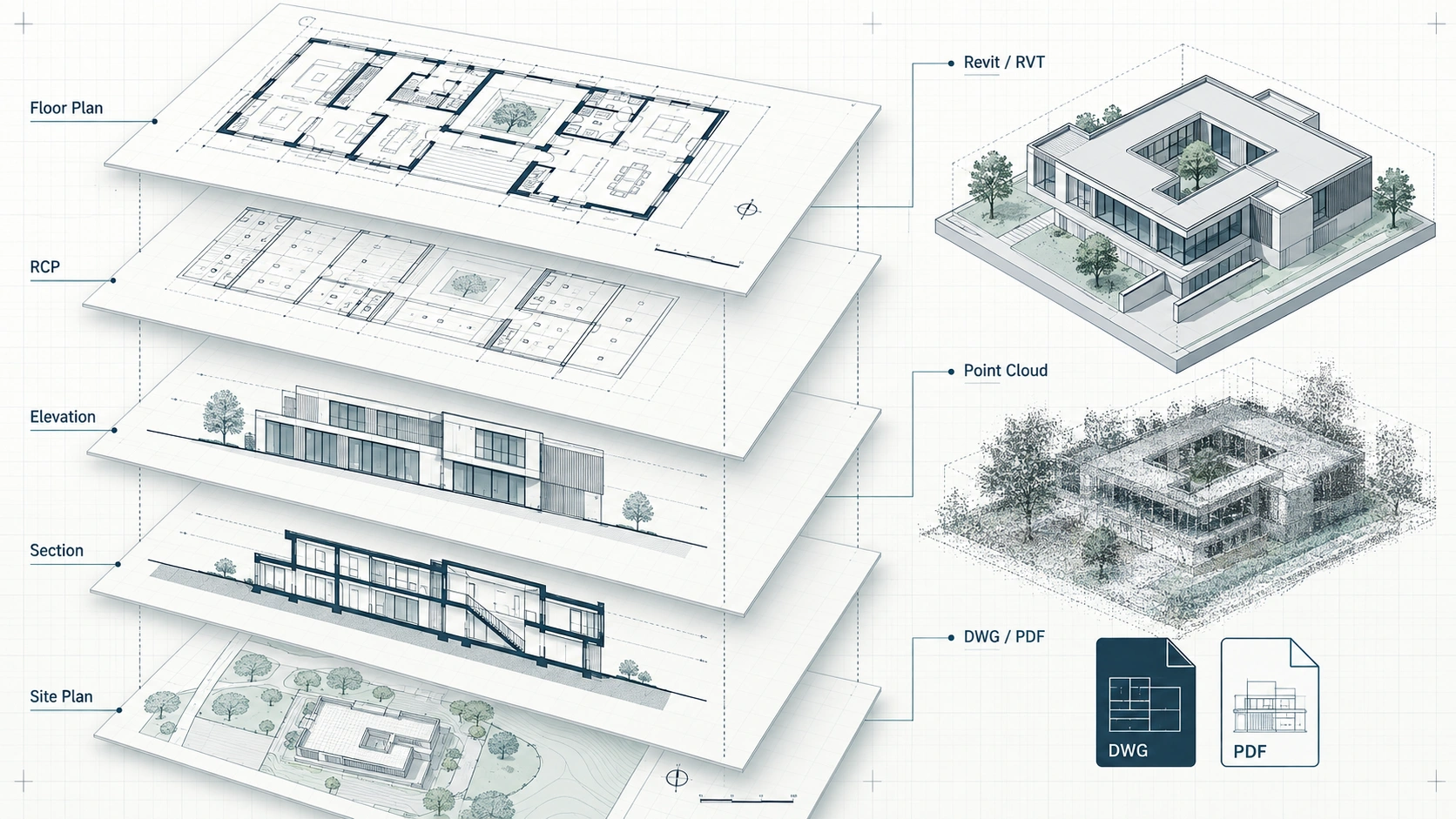
| Deliverable | What it records | Common renovation use |
|---|---|---|
| Floor plans | Walls, openings, rooms, major fixed features and dimensions | Space planning, demolition plans, layout design, contractor coordination |
| Elevations | Exterior or interior vertical geometry | Facade work, openings, finishes, heritage documentation |
| Sections | Floor-to-floor relationships, heights, stairs, roof and vertical interfaces | Structural coordination, additions, complex vertical conditions |
| Reflected ceiling plans | Ceiling geometry and visible ceiling features within scope | Interior design, lighting and services coordination |
| Site plans | Building relationship to surveyed exterior features where included | Site coordination and selected permit/design tasks |
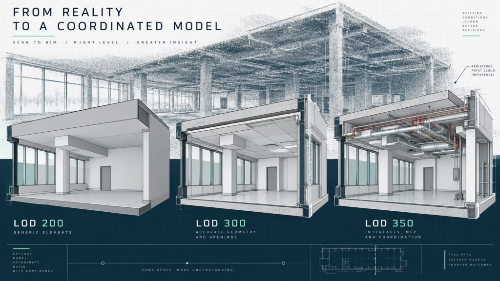
| Revit/BIM model | Modeled existing geometry at an agreed level of detail, commonly LOD 100–300 depending on scope | Scan-to-BIM, multidisciplinary coordination, design development |
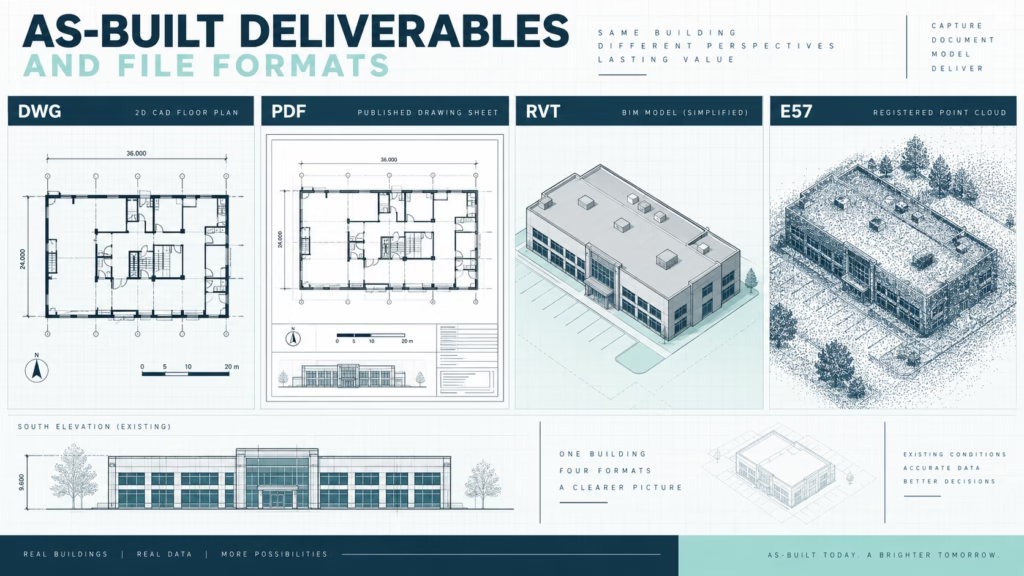
| DWG / PDF | Editable CAD geometry and issued drawing sheets | Architectural production, markup, consultant exchange |
| RVT | Native Revit project deliverable where specified | BIM-based renovation workflows |
| Point cloud | Registered spatial survey data | Verification, future measurement, section extraction, modeling reference |
For commercial leasing or square-footage verification, area calculations may be prepared to an agreed BOMA methodology when that is part of the assignment. BOMA is not assumed for every as-built project; it should be stated separately in the scope.
The point-cloud format also matters. RICS guidance recommends specifying formats that remain compatible with the intended users and can serve as an archive, rather than assuming any point-cloud file will fit every downstream system.
Accuracy, scope, and the limits of an as-built survey
Accuracy should be specified in relation to the project need, not advertised as a universal number. MeasureBuilt may work to a typical field accuracy around ±5 mm where the agreed scope, site conditions, visibility, control, and capture method support it, but that figure is not a guarantee for every feature or every project. The architect, contractor, fabricator, or consultant should identify dimensions that are especially critical before the survey is performed.
A survey also records what can be observed or otherwise included in the agreed scope; it does not automatically reveal concealed structure, hidden utilities, wall build-ups, foundations, or inaccessible spaces. If destructive investigation, utility locating, structural review, or another specialist service is required, that work should be commissioned separately and coordinated with the as-built base.
Outdated construction drawings should therefore be treated as evidence, not ground truth. They can help explain design intent and identify areas to inspect, but significant dimensions and interfaces should be checked when the renovation depends on them. Guidance for work in existing buildings similarly advises checking old records for plausibility and completeness when changed site conditions are possible.
Define the required tolerance, visible features, inaccessible areas, coordinate requirements, file formats, and modeling scope before capture. A precise survey with the wrong scope can still be the wrong deliverable.
How to recreate floor plans of an old building without over-documenting
Match survey detail to the renovation decisions. A kitchen reconfiguration does not need the same scope as a whole-building retrofit, while a multi-floor Scan-to-BIM project may require consistent levels, sections, facade geometry, and a model for several disciplines.
Start with a minimum information requirement
- Define the exact floors, rooms, exterior areas, roofs, or facades included.
- List project-critical features such as columns, beams, stairs, openings, ceiling changes, equipment, or visible services.
- State which deliverables are required and who will use them.
- Specify whether the team needs 2D CAD, PDF sheets, a Revit/BIM model, a point cloud, or a combination.
- Identify any critical dimensions or interfaces that need explicit field verification.
- Confirm whether the survey must align to a project coordinate system or an existing consultant model.
This avoids under-surveying, where a missing dimension forces a return visit, and over-surveying, where details are modeled that no consultant will use. The right survey is the smallest complete dataset that supports the project’s decisions.
Provider-selection checklist for a renovation survey
Evaluate the complete capture-to-delivery workflow. Scanner specifications alone do not show whether the final DWG, PDF, RVT, model, or point cloud will be useful to the architect or contractor.
- Scope definition: Can the provider translate the design team’s information needs into a field-capture scope?
- Capture method: Does the provider explain when manual measurement, 3D laser scanning, or a hybrid workflow is appropriate?
- Deliverables: Are floor plans, elevations, sections, reflected ceiling plans, site plans, DWG, PDF, RVT, Revit/BIM, and point-cloud outputs clearly specified?
- Modeling level: If BIM is required, is the expected LOD and modeled content agreed before production?
- Accuracy: Are tolerances described in relation to the survey scope rather than presented as a blanket promise?
- Quality control: Is there a process for checking drawings or models back against field data or the registered point cloud?
- File compatibility: Will the outputs work in the architect’s, designer’s, contractor’s, or consultant’s software environment?
- Access and exclusions: Are inaccessible areas, concealed conditions, site restrictions, and assumptions documented?
- Revision process: Is the method for resolving questions or scope changes after delivery clear?
For Vancouver and Lower Mainland projects, local project logistics can also affect access planning, survey sequencing, and coordination with active buildings. The technical requirement remains the same: establish a dependable current-condition base before the renovation team relies on it.
From missing plans to a usable renovation base
The MeasureBuilt approach
- Scan: Capture the agreed existing conditions in the building or renovation area using the appropriate field method.
- Point cloud: Register and review spatial data so the drafting or modeling team has a coherent geometric reference.
- Drawings or model: Produce the specified floor plans, elevations, sections, reflected ceiling plans, DWG/PDF drawings, or RVT/Revit BIM model.
- Delivery: Issue the agreed files for the architect, designer, contractor, developer, property manager, or permitting team.
MeasureBuilt provides as-built measurement and 3D laser scanning workflows for Greater Vancouver and the Lower Mainland, with deliverables selected around the project rather than a one-size-fits-all drawing package.
When original drawings are missing, the goal is a current design base the renovation team can coordinate against. That may be a concise 2D floor-plan package, a broader set of elevations and sections, or a Scan-to-BIM workflow built from a registered point cloud.
Missing original drawings should change the first step of a renovation, not stop the project. Recover whatever records are available, test whether they match the building, define the information the design team actually needs, and commission a measured as-built survey when the geometry cannot be trusted. A well-scoped survey turns an undocumented building into a usable set of existing-condition drawings or a BIM base for design, coordination, pricing, and permitting. Request a quote at measurebuilt.com/request-a-quote to get a fixed price and timeline for your as-built survey.
FAQ
Can I renovate if the original building plans are missing?
Yes. A renovation can proceed without the original plans, but the design team still needs reliable existing-condition information. Start by collecting any historical records that exist, then verify them against the building. If dimensions, levels, openings, or previous alterations are uncertain, commission an as-built survey and create new floor plans, sections, elevations, CAD drawings, or a BIM model as required.
Where should I look for drawings of an existing building before ordering a survey?
Start with owner and property-management files, previous consultant packages, permit records available to the project team, old CAD or PDF files, renovation markups, and handover documents. Treat recovered drawings as reference until their geometry is checked against current conditions. Finding a plan can reduce research time, but it does not prove that the building was built or later modified exactly as shown.
Do I need 3D laser scanning if I only need floor plans?
Not always. A small, simple, accessible space may be documented efficiently with manual measurement, while larger or irregular buildings can benefit from 3D laser scanning because the point cloud preserves more geometry for drafting and later verification. The decision should consider building complexity, the likelihood of return visits, required accuracy, and whether sections, elevations, ceiling plans, or BIM may be needed later.
What files can be produced from an as-built survey?
The output can include floor plans, elevations, sections, reflected ceiling plans, site plans, DWG, PDF, RVT, a Revit/BIM model, and a registered point cloud. The correct package depends on who will use the information and what decisions they must make. Specify file formats, drawing content, BIM scope, and point-cloud requirements before field capture so the survey is designed around the final deliverable.
Can outdated construction drawings be used for renovation design?
They can be used as a reference, but they should not automatically be treated as current site geometry. Buildings may differ from design drawings because of construction changes, later renovations, fit-outs, or incomplete records. When important dimensions or interfaces are uncertain, verify them on site and create updated existing conditions documentation before detailed design relies on the old set.
How accurate are MeasureBuilt as-built measurements?
Accuracy depends on scope, site conditions, visibility, control, capture method, and the feature being measured. MeasureBuilt may work to a typical field accuracy around ±5 mm where the project conditions and agreed scope support it, but that is not a universal guarantee. Critical fabrication, structural, or installation dimensions should be identified in advance so the survey approach can be matched to the project requirement.

Analyse this page with AI
Want a summary, fact-check, or an RFP template built around these measurement standards? Send this page directly to your favourite AI model.
Content and prompt will be copied to clipboard for some models.