Heritage Building Documentation with 3D Laser Scanning in BC

Quick answer

Heritage building documentation with 3D laser scanning creates a measured digital record of existing conditions before conservation, renovation, adaptive reuse or structural work begins. A registered point cloud can support floor plans, elevations, sections, CAD drawings and Revit/HBIM models while preserving irregular geometry that simplified legacy drawings may miss. The correct workflow starts with a defined survey scope, required tolerances, coverage and final file formats.

Historic buildings are rarely geometrically simple. Walls drift out of square, floor levels change, façades include layered details, and previous alterations may not be reflected in available drawings. For British Columbia project teams, 3D laser scanning provides a practical way to capture those conditions once and convert them into reliable existing-conditions documentation for design, conservation and coordination.

What heritage building documentation must capture before design starts

A heritage survey should be specified around the decisions the project team needs to make. Heritage recording guidance distinguishes interpretive records from metric geospatial survey: written descriptions and photographs help explain significance, while measured survey, laser scanning and photogrammetry establish the spatial framework. For architects, conservation consultants and engineers, the practical takeaway is to define whether the project needs documentation for design, repair, monitoring, archival record, BIM coordination or several of those purposes.

Key documentation risks to resolve early

  • Incomplete coverage: hidden rooms, roofs, façades, stair cores or service spaces can create gaps in the record.
  • Undefined deliverables: a point cloud, 2D drawing set and Revit model are different products and should not be treated as interchangeable.
  • Excessive simplification: historic walls, openings and structural elements may be irregular and should not be forced into idealized geometry without agreement.
  • Unclear tolerance: the survey brief should state the level of metric reliability required for the intended design or conservation task.
  • Poor data handoff: file formats, coordinate system, model scope and archival requirements should be agreed before field capture.

Measured documentation is especially valuable when original drawings are missing, outdated or too schematic for intervention planning. Canadian digital heritage work at the University of Calgary shows how LiDAR point clouds can document doors, windows, rooflines, floor areas and other architectural measurements, and how point clouds can be used to create as-built records where current plans do not exist. The same principle applies to heritage renovation workflows in British Columbia: capture the existing fabric before drawing assumptions become design constraints.
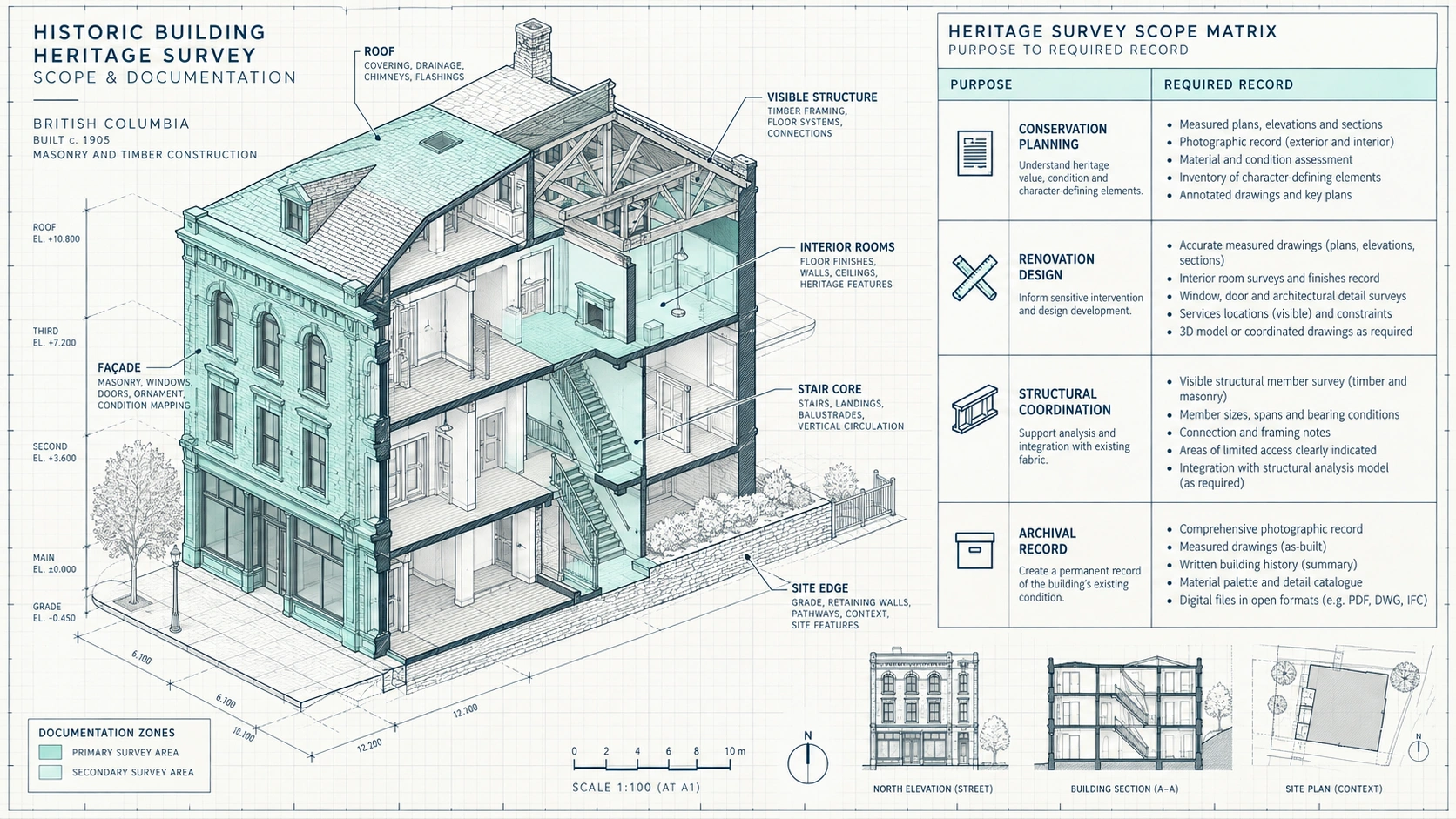
Heritage building documentation cutaway showing survey zones for interiors, façade, roof, structure and site context

How 3D laser scanning creates heritage building documentation

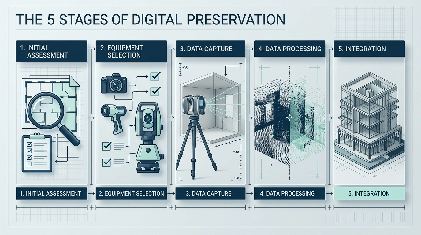
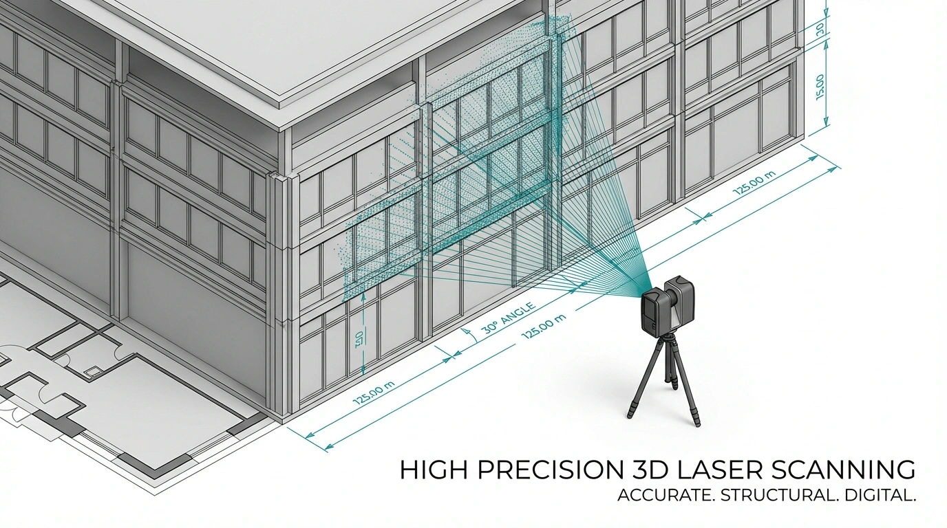
3D laser scanning records building surfaces as spatial coordinates and combines repeated scanner positions into a registered point cloud. A scanner only records surfaces visible from each setup, so field planning matters: the crew moves through and around the building to capture overlapping views of rooms, circulation, façades and other required areas. The result is a dense three-dimensional reference that can be viewed, measured and used as the basis for drawings or models.

1. Define survey scope and control

The survey scope should identify the areas to capture, required outputs, intended uses and any site constraints. Historic England’s geospatial guidance treats survey specification as a core part of producing data that is fit for purpose. For a BC heritage project, this means confirming whether the team needs interior and exterior geometry, roof context, façade ornament, structural features, visible services, site relationships or only selected zones.

2. Capture overlapping scan positions

Laser scanning historic buildings requires enough scanner positions to reduce occlusions and maintain continuity through irregular spaces. Complex stairs, thick wall openings, vaulted areas, narrow service rooms and articulated façades may need additional setups. The objective is not to maximize scan count; it is to create complete coverage for the agreed deliverables while avoiding blind areas that later force a return visit.

3. Register and quality-check the point cloud

Individual scans are aligned into a common coordinate framework during registration. Quality control should then confirm coverage, alignment and whether the dataset supports the specified drawing or modeling task. A point cloud is a measured dataset, not a finished BIM model. It becomes useful to the design team when it is organized, checked and delivered in a format compatible with the downstream CAD or BIM workflow.

4. Convert survey data into drawings or HBIM

The registered point cloud can be traced and interpreted into floor plans, elevations, sections, reflected ceiling plans, site plans or a Revit/BIM model. For HBIM for heritage projects, the model should remain tied to observed existing conditions rather than replacing complex historic fabric with generic components. Model detail should be scoped to project needs, with LOD 100–300 used only where the required geometry and information justify it.

The point cloud is the measured reference; the DWG, PDF or RVT deliverable is an interpreted project document. Specify both the capture requirements and the final output.
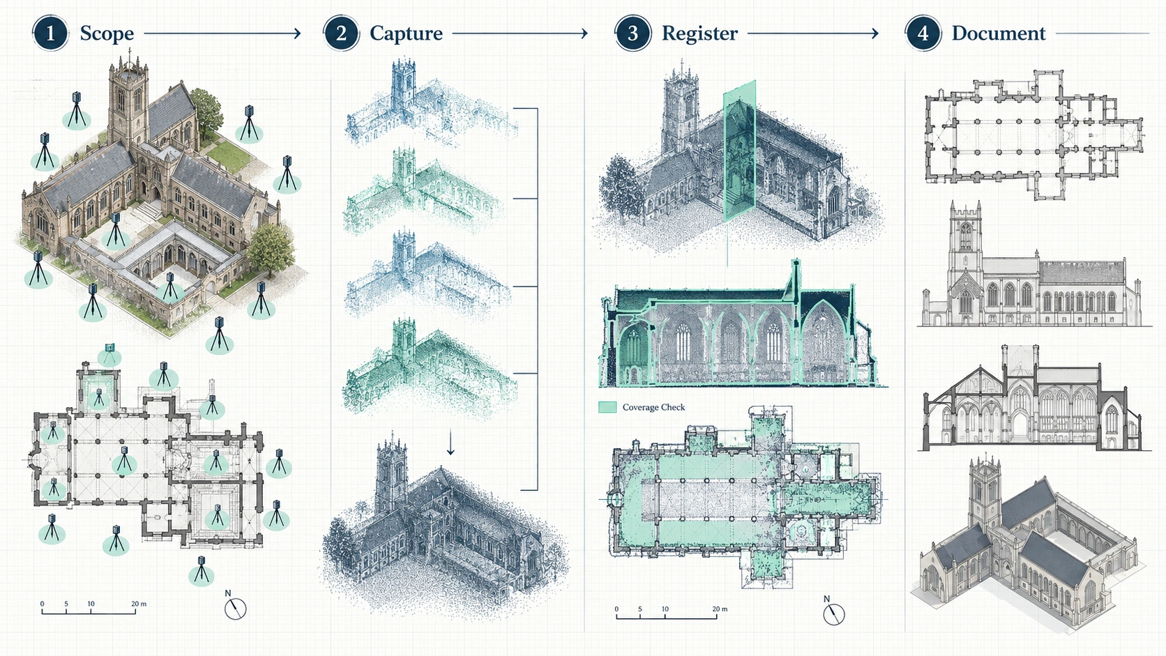
Four-stage heritage laser scanning workflow from field capture to point cloud, drawings and Revit model

Laser scanning, photogrammetry and manual measurement: when each method fits

No single capture method is automatically correct for every historic building. Heritage survey guidance recognizes laser scanning, photogrammetry and measured building survey as complementary techniques. The choice depends on geometry, surface detail, access, required outputs and the purpose of the record. A complex interior may favour terrestrial LiDAR, detailed façades may benefit from photographic capture, and small accessible elements may still be efficiently checked with direct measurement.

MethodBest suited toTypical outputKey limitation to manage
3D laser scanning / LiDARComplex interiors, irregular geometry, multi-level existing conditionsRegistered point cloud, measured base for CAD or BIMLine of sight creates occlusions if scan positions are incomplete
Photogrammetry / SfMSurface-rich façades, decorative elements, exterior contextImage-based 3D geometry, textured surface recordQuality depends on image coverage, visibility and capture conditions
Manual measured surveySmall, accessible and relatively simple areas or verification checksDimensions, sketches, selective measured drawingsLarge or irregular buildings can require more interpretation and repeated field checks
Hybrid captureProjects needing metric geometry plus detailed visual contextPoint cloud combined with imagery, CAD and/or BIMRequires a clear data-management and deliverable plan

For heritage conservation drawings in BC, the useful question is not which technology sounds most advanced. The useful question is which dataset lets the conservation architect, engineer or contractor make the required decision with the least ambiguity. A hybrid workflow can be appropriate where LiDAR establishes geometry and photography documents material character or decorative detail that should remain visually traceable.

When heritage projects in Vancouver and the Lower Mainland benefit from scanning

Heritage-sensitive renovation is a strong use case for measured reality capture in Vancouver and the Lower Mainland because older buildings can combine irregular geometry, previous alterations and difficult access. Local Canadian service providers describe heritage-sensitive documentation, dense urban renovations and existing-condition capture as recurring project types, with point clouds, DWG/PDF drawings and Revit models used for downstream design and coordination.

Adaptive reuse and major renovation

Adaptive reuse needs a dependable record of the building that exists, not the building shown on an old drawing set. 3D scanning can establish wall positions, openings, floor relationships, stairs, visible structure and other geometry before new layouts are developed. Heritage revitalization documentation Vancouver teams commission is most useful when the deliverable is matched directly to design scope rather than produced as a generic scan archive.

Structural and seismic coordination

Structural work often depends on how new interventions connect to existing fabric. A point cloud gives engineers and architects a shared spatial reference for visible geometry, while sections and elevations can communicate the same conditions in conventional drawing form. Scanning does not replace engineering investigation, destructive review where required or professional judgment; it improves the geometric base those disciplines coordinate against.

Façade, envelope and conservation detailing

Historic façades can contain offsets, ornament, non-uniform openings and accumulated modifications that are difficult to represent from sparse dimensions. Laser scanning and photogrammetry can provide complementary records for façade elevations and detail studies. Where surface appearance matters, imagery should be captured and managed as part of the documentation strategy instead of assuming a geometric point cloud alone will answer material-condition questions.

Missing or unreliable record drawings

Measured drawings for heritage buildings become critical when legacy plans are unavailable or cannot be trusted as current conditions. The University of Calgary’s digital heritage archive specifically describes using point clouds to create as-built versions of heritage buildings that lack up-to-date architectural plans. For project teams, this supports a simple decision rule: verify existing geometry before using legacy drawings as a design base.
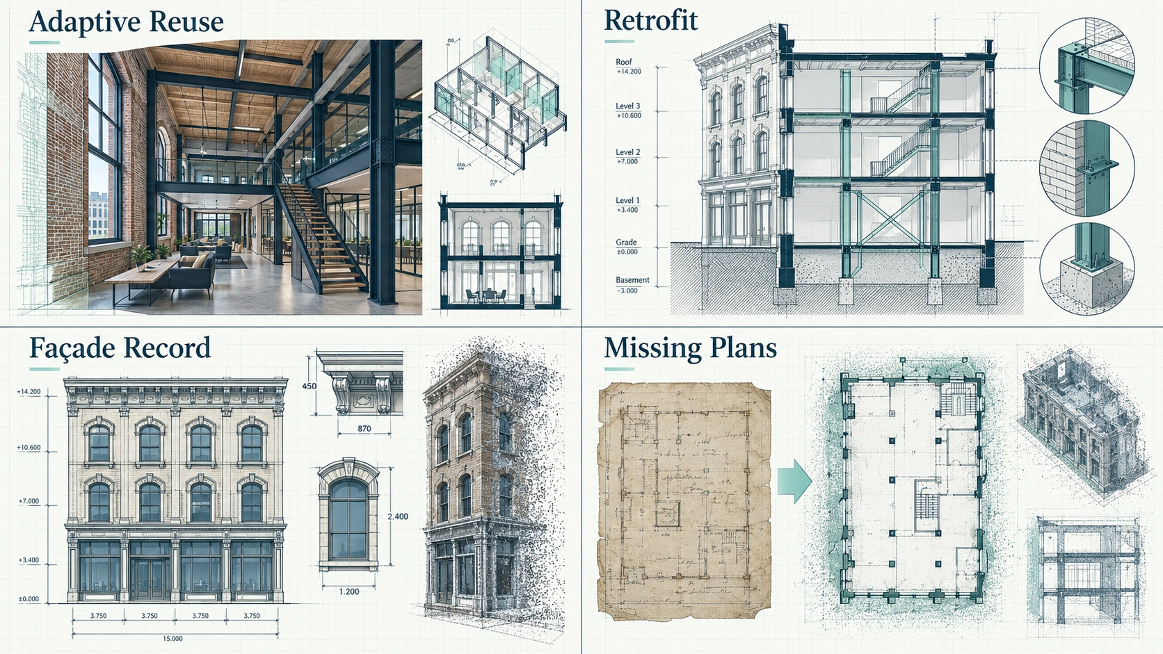
Adaptive reuse, retrofit, façade documentation and missing-plan heritage scanning use cases

Deliverables: from point cloud to measured drawings and HBIM

The correct heritage deliverable depends on who will use the information next. A conservation architect may need dimensioned elevations and sections; an interior design team may need floor plans and reflected ceiling plans; a multidisciplinary retrofit may benefit from a Revit model linked back to the point cloud. The survey should therefore be commissioned around deliverables, not around scanning as an isolated field service.

  • Registered point cloud: the spatial reference for measurement, coordination and future re-use.
  • Floor plans: wall geometry, openings, rooms, stairs and other agreed existing-condition elements.
  • Elevations: exterior or interior vertical geometry for conservation and design documentation.
  • Sections: floor-to-floor relationships, roof forms, structural zones and spatial conditions.
  • Reflected ceiling plans: ceiling geometry and visible overhead elements where included in scope.
  • Site plans: building position and surrounding context where the survey scope includes exterior/site capture.
  • DWG and PDF: conventional 2D documentation for design review, markup and construction coordination.
  • RVT / Revit-BIM model: modeled existing conditions for Scan-to-BIM or HBIM workflows.
  • LOD 100–300 model scope: selected according to the design purpose and agreed modeling requirements, not assumed by default.

HBIM adds information management to geometry. Heritage guidance describes BIM as a collaborative process for producing and managing structured electronic information and notes that a heritage Asset Information Model can act as a digital repository for repair, maintenance and asset information. The practical implication is that HBIM should be planned around information use, naming, model scope and future stewardship rather than treated as a visually detailed 3D model alone.

Ask for the lightest deliverable that fully supports the next project decision. A full Revit model is valuable when the team will coordinate in BIM; it is unnecessary when dimensioned 2D drawings answer the design need.

Accuracy, scope and provider selection for a heritage survey

Heritage documentation should use project-specific accuracy and completeness criteria instead of broad promises. Survey guidance emphasizes fit-for-purpose specifications, and historic buildings often require different levels of detail across different areas. A façade conservation package, a tenant renovation and a structural retrofit may all use laser scanning, but they should not automatically receive the same capture density, drawing content or model complexity.

  • Technology: Confirm whether terrestrial laser scanning, photogrammetry, direct measurement or a hybrid workflow is appropriate for the building and access conditions.
  • Coverage: Define interiors, façades, roofs, stairs, service areas, site context and any areas that may be inaccessible.
  • Accuracy: State the required project tolerance and how registration and quality control will be checked.
  • Deliverables: List floor plans, elevations, sections, RCPs, site plans, point cloud, DWG, PDF, RVT or other required files.
  • BIM scope: Define disciplines, modeled elements, LOD expectations and how irregular historic geometry will be represented.
  • Coordinate framework: Confirm whether the project requires local coordinates, survey control or another agreed reference system.
  • Data access: Confirm file formats, point-cloud compatibility, archive requirements and whether raw or registered data is included.
  • Heritage workflow: Identify conservation consultants, architects or other stakeholders who need to review the record before design proceeds.

A strong provider should also explain exclusions. Laser scanning records visible surfaces; concealed structure, hidden assemblies and material condition require other investigation methods. Likewise, a point cloud does not interpret significance or replace a conservation assessment. Keeping geometric capture, architectural interpretation and conservation judgment distinct prevents the digital record from being asked to answer questions it was never designed to resolve.

The MeasureBuilt approach

  1. Scan: capture the agreed existing conditions across the required interior, exterior and site areas.
  2. Point cloud: register and quality-check the LiDAR data as the measured spatial reference.
  3. Drawings or model: convert the survey into the agreed DWG/PDF documentation or RVT/Revit-BIM model.
  4. Delivery: provide the project files for the design, conservation or coordination workflow across Greater Vancouver and the Lower Mainland.
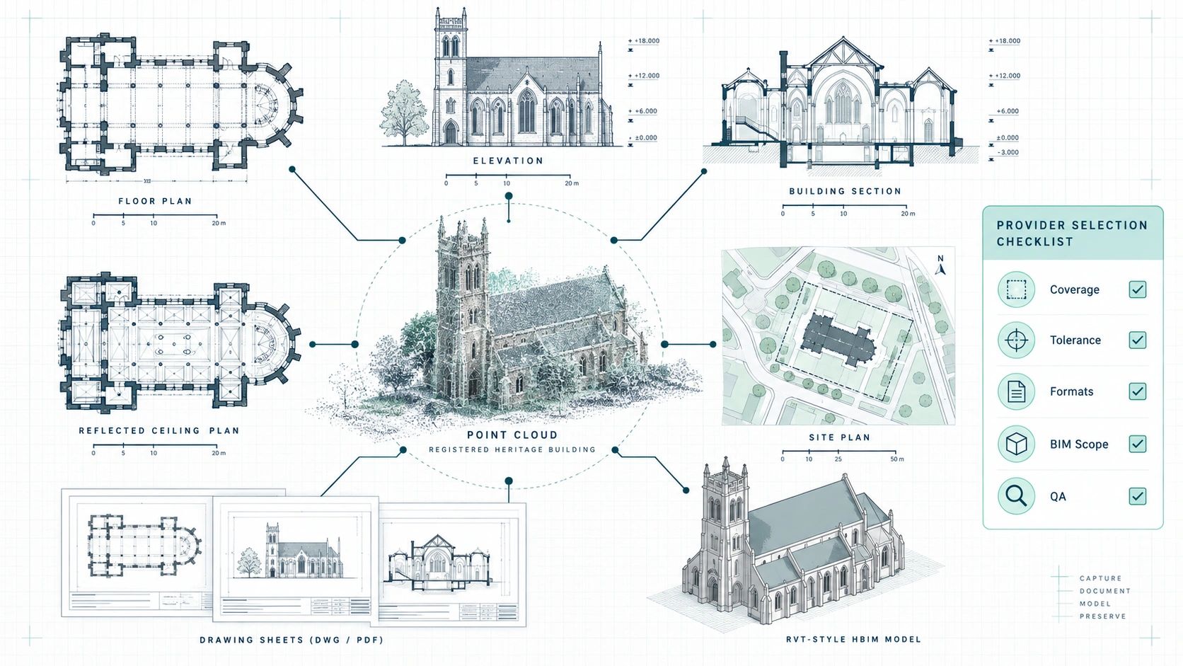
Heritage point cloud connected to floor plans, elevations, sections, RCP, site plan and Revit deliverables

Heritage building documentation works best when the survey is treated as part of the project information strategy, not simply as a scanning appointment. Define the decisions the team must make, set the required coverage and tolerance, and choose deliverables that match the architect, engineer, conservation consultant and contractor workflows. For complex historic buildings in British Columbia, a registered point cloud can provide the measured base for drawings, coordination and HBIM without idealizing irregular existing geometry. Request a quote at measurebuilt.com/request-a-quote to get a fixed price and timeline for your as-built survey.

FAQ

Is 3D laser scanning suitable for heritage buildings with irregular geometry?

Yes. 3D laser scanning is well suited to irregular historic geometry because it records visible surfaces as three-dimensional spatial data rather than relying only on selected hand dimensions. The resulting point cloud can preserve wall deviations, uneven floor relationships, complex openings and façade geometry for later drafting or modeling. Complete coverage still depends on line of sight and enough scan positions.

Can a point cloud replace heritage conservation drawings?

No. A point cloud is a measured spatial dataset, while conservation drawings are interpreted project documents. Architects and consultants may use the point cloud to produce floor plans, elevations, sections and details, but the drawing set still needs defined content, conventions and professional interpretation. Commission the point cloud and the required drawing deliverables as separate, clearly scoped outputs.

What is the difference between Scan-to-BIM and HBIM for a heritage project?

Scan-to-BIM converts measured survey data into a BIM model, while HBIM applies BIM methods to historic assets and their information needs. For heritage work, the model may need to represent irregular existing geometry and organize information for conservation, repair or asset management. The required model detail should follow the project’s intended use rather than visual complexity alone.

What files should an architect request for a heritage renovation?

Request the files that match the design workflow. A common package can include a registered point cloud plus DWG/PDF floor plans, elevations and sections; a Revit-based team may also require an RVT model. Reflected ceiling plans, site plans or façade-focused documentation should be added only when the renovation scope needs them. Confirm file versions and coordinate requirements before scanning.

Does laser scanning document hidden structural conditions?

No. Laser scanning documents visible surfaces within the scanner’s line of sight. It can provide a precise geometric reference for visible walls, floors, ceilings, openings and exposed structure, but it does not reveal concealed assemblies behind finishes. Structural investigation, openings, testing or other specialist methods may still be required depending on the project.

When should a BC heritage project be scanned?

Scan before design decisions depend on uncertain existing geometry. The strongest timing is usually after access and documentation goals are defined but before renovation, conservation detailing or retrofit coordination advances too far. Early capture gives the team a shared existing-conditions reference and reduces the need to base drawings on outdated records or assumptions.
Heritage Building Documentation Vancouver: 3D Scanning Guide

Measure Built delivers millimeter-accurate heritage building documentation using advanced 3D laser scanning and Scan-to-BIM workflows – giving architects, engineers, and contractors a verified digital foundation for restoration and renovation projects across Greater Vancouver.

Protect Heritage. Eliminate Guesswork. Build with Confidence.

Heritage buildings are unpredictable by nature. Over time, they shift, settle, and evolve – often without reliable drawings or documentation.

Manual measurements and outdated plans introduce risk at every stage of a project:

  • Structural inaccuracies
  • Design conflicts during renovation
  • Permit delays and rejections
  • Expensive construction rework
  • Loss of historical architectural detail

When working with heritage properties in Vancouver, precision is not optional – it is essential.

The Problem with Traditional Heritage Documentation

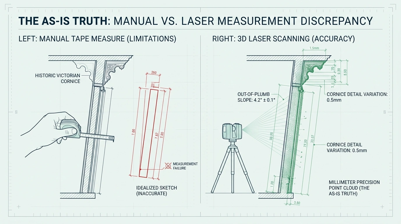
Most heritage projects still rely on outdated methods such as tape measurements, partial sketches, or legacy drawings that no longer reflect reality.

These approaches fail because they:

  • Assume buildings are geometrically perfect (they are not)
  • Miss structural deformation and settlement
  • Overlook hidden architectural complexity
  • Create inconsistencies between disciplines
  • Lead to costly redesigns during construction

In heritage restoration, even small measurement errors can result in major project delays and financial loss.

LiDAR versus manual measurement for heritage building documentation

The Measure Built Solution: Reality Capture for Heritage Buildings

We replace assumptions with verified spatial data using advanced 3D laser scanning.

Our process creates a complete, millimeter-accurate digital representation of the building – capturing:

  • Structural geometry
  • Architectural details and ornamentation
  • Floor level deviations and wall deformation
  • Ceiling conditions and spatial irregularities
  • Existing building envelope conditions

This becomes a single source of truth for architects, engineers, and contractors.

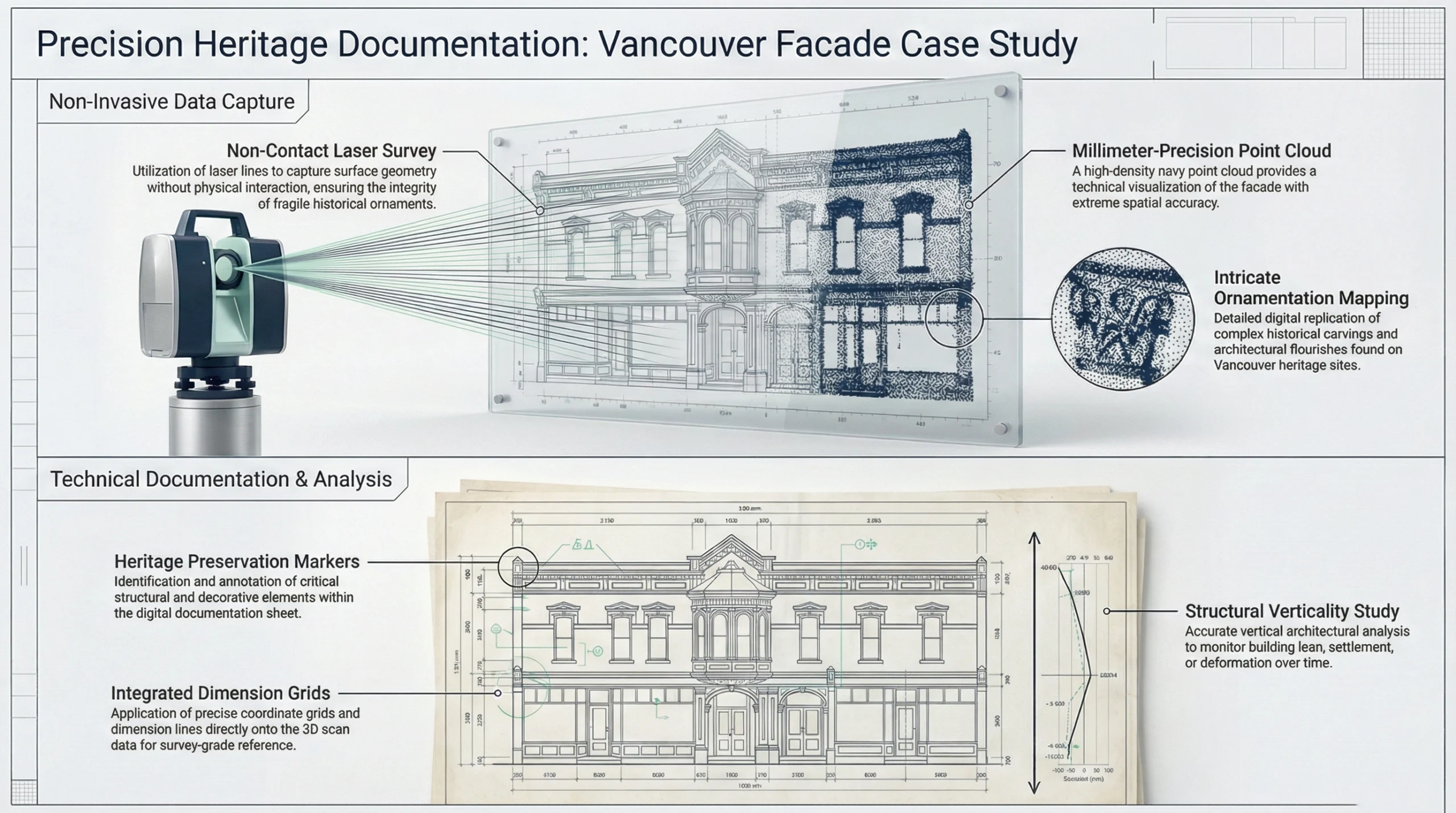
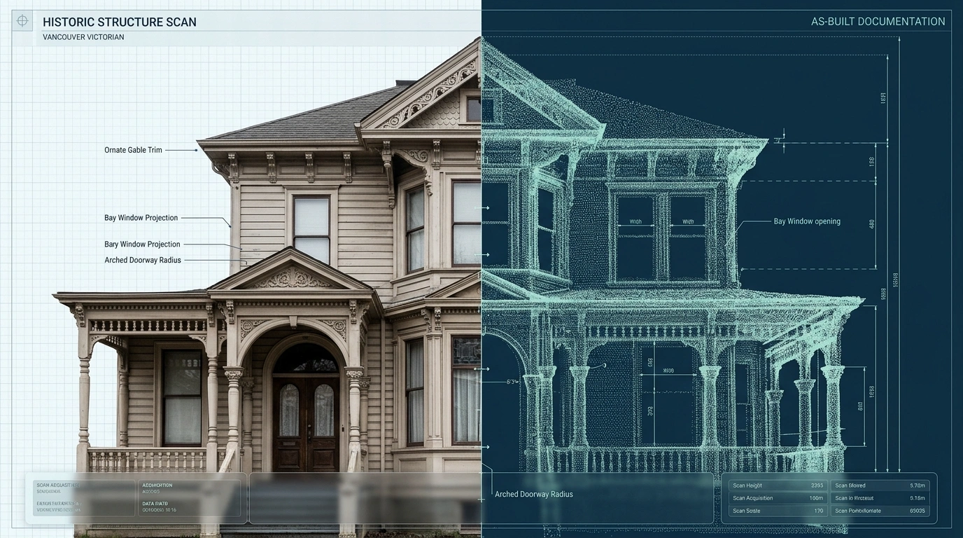
Victorian facade captured as a detailed 3D point cloud in Vancouver

What You Get: Deliverables Built for Design & Permitting

Measure Built delivers construction-ready documentation tailored for heritage and complex renovation projects:

Core Deliverables

  • Registered 3D point cloud (E57 / RCP / LAS)
  • Accurate 2D as-built floor plans
  • Elevations and building sections
  • Reflected ceiling plans (RCP)
  • Site context documentation

Advanced Options

  • Scan-to-BIM models (Revit / IFC)
  • Heritage Building Information Modeling (HBIM)
  • Coordination-ready CAD drawings (DWG)

Why 3D Laser Scanning Is Essential for Heritage Projects

Heritage buildings require a level of accuracy that traditional methods cannot provide.

With laser scanning, you can:

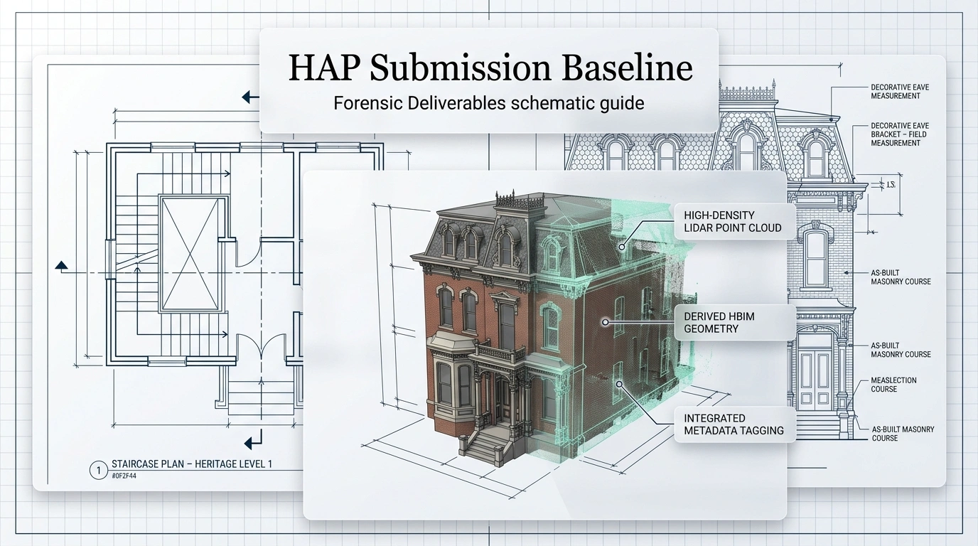
✔ Capture complex geometry with millimeter precision ✔ Document fragile or decorative architectural elements safely ✔ Reduce risk during restoration design ✔ Eliminate uncertainty before construction begins ✔ Support Heritage Alteration Permit (HAP) applications

This is not just documentation – it is risk control.

Built for Vancouver's Heritage & Regulatory Environment

We understand the requirements of:

  • Vancouver Building By-law (VBBL)
  • BC Building Code (BCBC)
  • Heritage Conservation Area guidelines
  • Heritage Alteration Permit (HAP) submissions
  • Municipal zoning and review processes

Our documentation is structured to support clear, defensible permit applications that align with municipal expectations.

Heritage Alteration Permit documentation supported by accurate as-built scanning in Vancouver

Reduce Risk Before Design Begins

Heritage renovation failures are rarely design problems – they are data problems.

Without accurate existing-condition data, projects face:

  • Misaligned structural coordination
  • Fabrication errors in custom elements
  • Permit revisions and delays
  • Unpredictable construction costs

With a verified digital twin, teams can:

  • Detect clashes before construction
  • Align architectural and structural systems
  • Produce accurate contractor estimates
  • Reduce contingency budgets
  • Improve schedule certainty

Ideal For

Measure Built heritage scanning services are used by:

  • Architects
  • Heritage consultants
  • Structural engineers
  • General contractors
  • Interior designers
  • Property owners of historic buildings

Typical projects include:

  • Heritage home restoration
  • Adaptive reuse of older commercial buildings
  • Structural upgrades and additions
  • Interior redesign of historic properties
  • Permit documentation for protected structures

Our Process

1. Site Capture Non-intrusive 3D laser scanning of the entire structure.

2. Data Processing Registration of scan data into a unified, accurate point cloud.

3. Modeling & Drafting Conversion into CAD or BIM deliverables based on project scope.

4. Quality Control Verification of accuracy and consistency across all deliverables.

5. Delivery Final architectural-grade documentation ready for design and permitting.

Heritage scanning lifecycle from site capture to final documentation in Vancouver

Why Measure Built

  • Millimeter-level accuracy (typically 2–5 mm)
  • Non-invasive capture for fragile heritage structures
  • Fast on-site scanning with minimal disruption
  • Deliverables aligned with architectural workflows
  • Trusted baseline for permitting and construction

We don't estimate buildings – we document them exactly as they exist.

Frequently Asked Questions

How accurate is 3D laser scanning?

Typically within 2–5 mm, far exceeding manual measurement methods.

Is scanning safe for heritage buildings?

Yes. The process is completely non-contact and non-invasive.

Can this help with Heritage Alteration Permits?

Yes. Municipalities require accurate existing-condition documentation for approval.

What formats do you deliver?

We provide point clouds (E57/RCP/LAS), CAD drawings (DWG), and BIM models (Revit/IFC).

Does scanning replace land surveying?

No. Surveying defines property boundaries; scanning documents building geometry.

Conclusion

Start Your Heritage Project With Confidence

Before you design, restore, or apply for permits – make sure your project is based on reality, not assumptions.

Measure Built provides the accurate foundation needed to preserve, restore, and transform heritage buildings across Vancouver.

Sustainable Surveying Vancouver: Green Building Documentation

Vancouver's construction industry is operating under increasing environmental pressure. The City's Climate Emergency Action Plan, the Vancouver Building By-law (VBBL), and aggressive 2030 zero-emissions targets are reshaping how buildings are designed, renovated, and documented.

Sustainability is no longer limited to materials and mechanical systems. It now begins at the measurement stage.

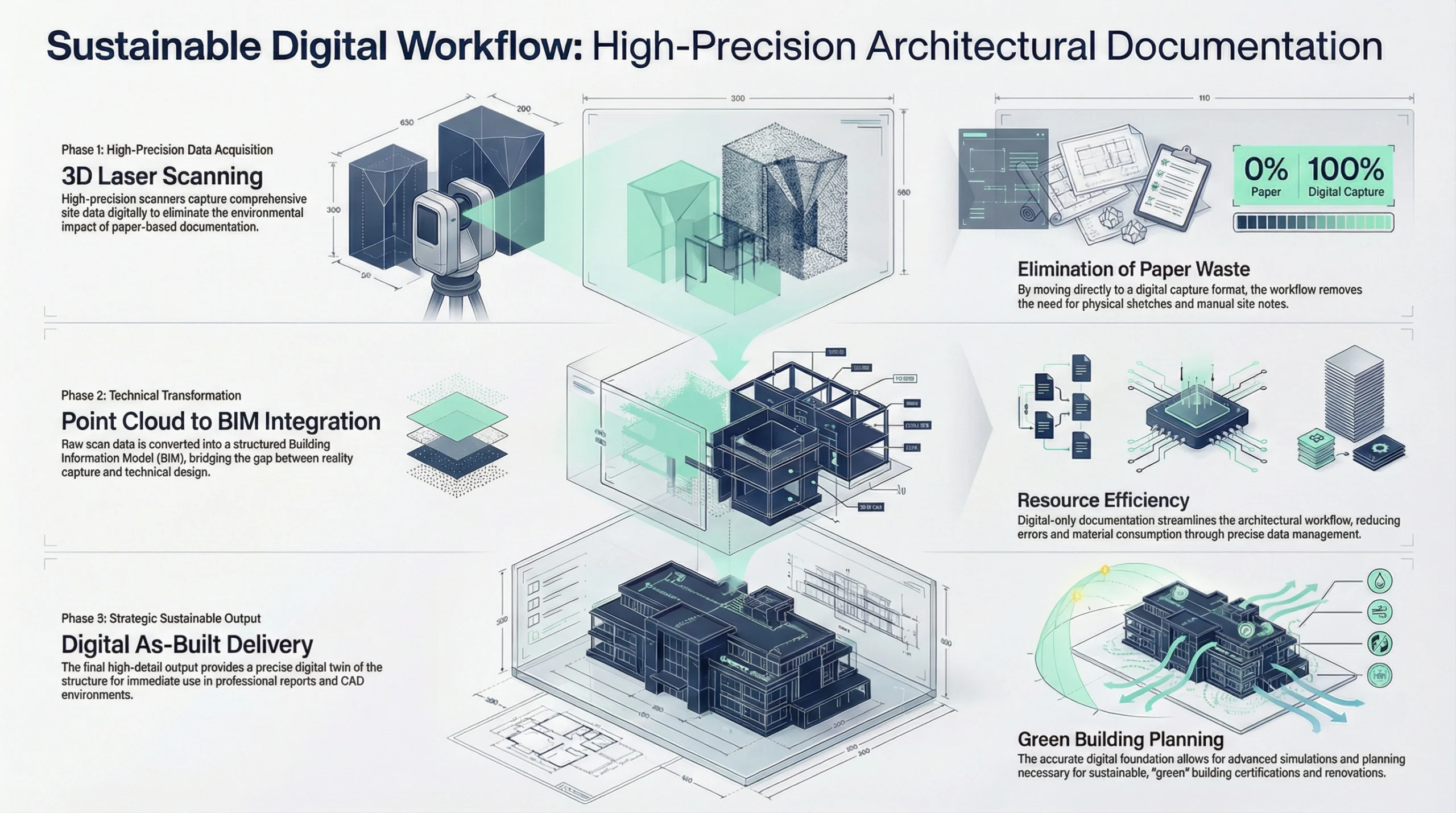
Sustainable surveying in Vancouver represents a shift from analog, error-prone documentation toward high-precision digital capture that reduces waste, minimizes carbon emissions, and supports green building compliance. For developers, architects, contractors, and property owners, accurate data is now a sustainability tool.

What Is Sustainable Surveying?

Sustainable surveying is the use of low-impact, digital-first measurement technologies – primarily 3D laser scanning and LiDAR – to document buildings and sites with minimal environmental disruption.

Traditional surveying often involves:

  • Multiple return site visits
  • Manual measurement errors
  • Paper-heavy workflows
  • Physical access equipment and disruption

Modern sustainable surveying replaces this with:

  • Non-contact LiDAR scanning
  • High-density point cloud capture
  • Digital deliverables (CAD, BIM, area reports)
  • Remote collaboration

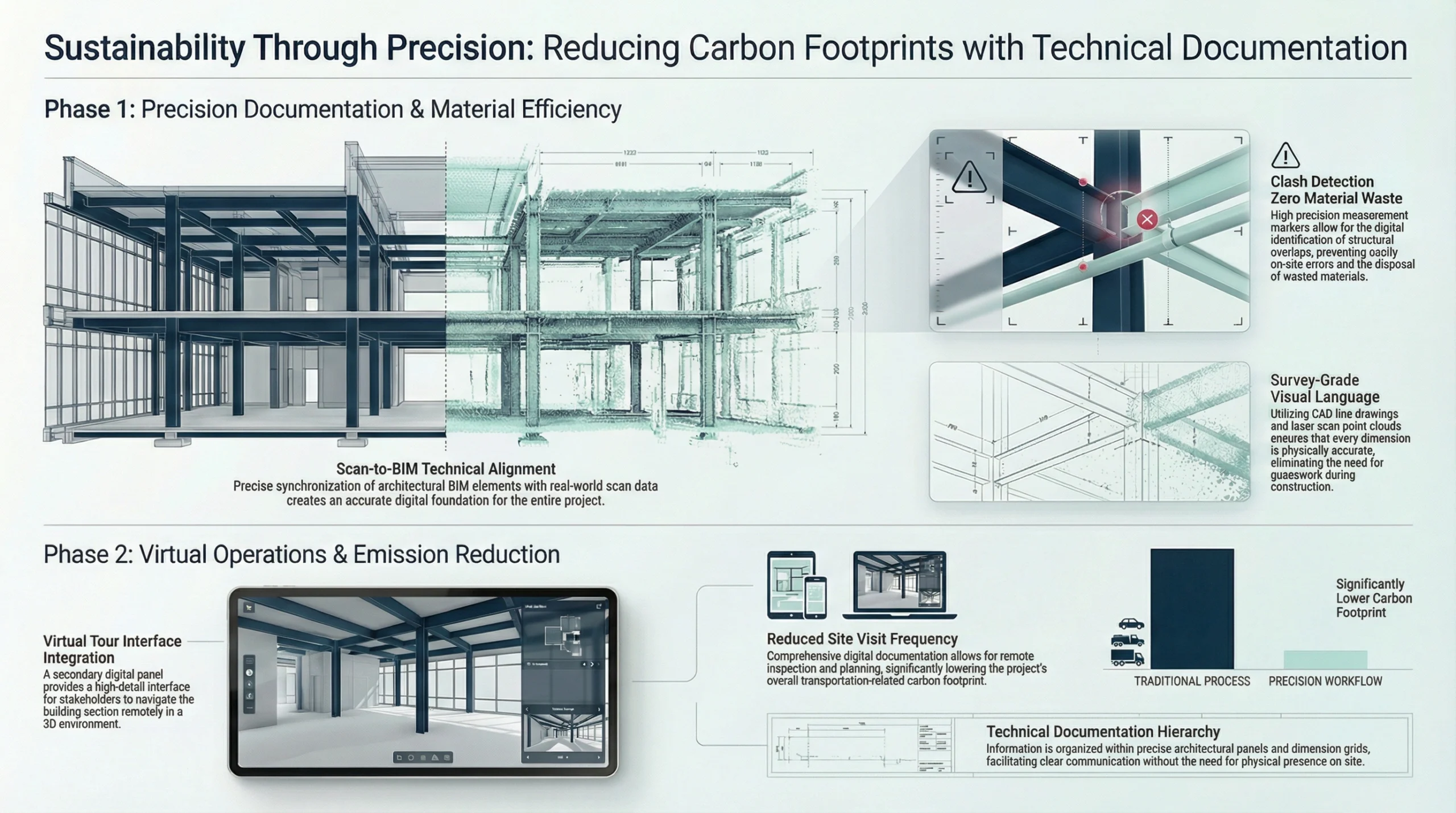
The environmental benefit is twofold: fewer site trips and fewer construction errors.

Digital workflow for sustainable surveying in Vancouver using LiDAR, point clouds, CAD, and BIM

Accuracy as a Carbon Reduction Strategy

In construction, inaccuracy equals waste.

Every incorrect dimension leads to:

  • Reordered materials
  • Demolition and rework
  • Increased embodied carbon
  • Extended project timelines

3D laser scanning captures millions of data points in a single visit, producing accurate floor plans and digital twins that eliminate guesswork.

When contractors fabricate millwork, steel, glazing, or mechanical components based on verified measurements, materials fit the first time. That precision directly reduces landfill waste and embodied carbon.

Supporting Vancouver's 2030 Zero-Emissions Goals

The City of Vancouver aims to:

  • Achieve zero emissions in new buildings by 2030
  • Dramatically reduce emissions from existing building stock

Meeting these targets requires accurate documentation of existing conditions.

Deep Energy Retrofits

Retrofitting older buildings requires exact knowledge of:

  • Envelope geometry
  • Slab edges
  • Thermal bridge locations
  • Window openings
  • Roof profiles

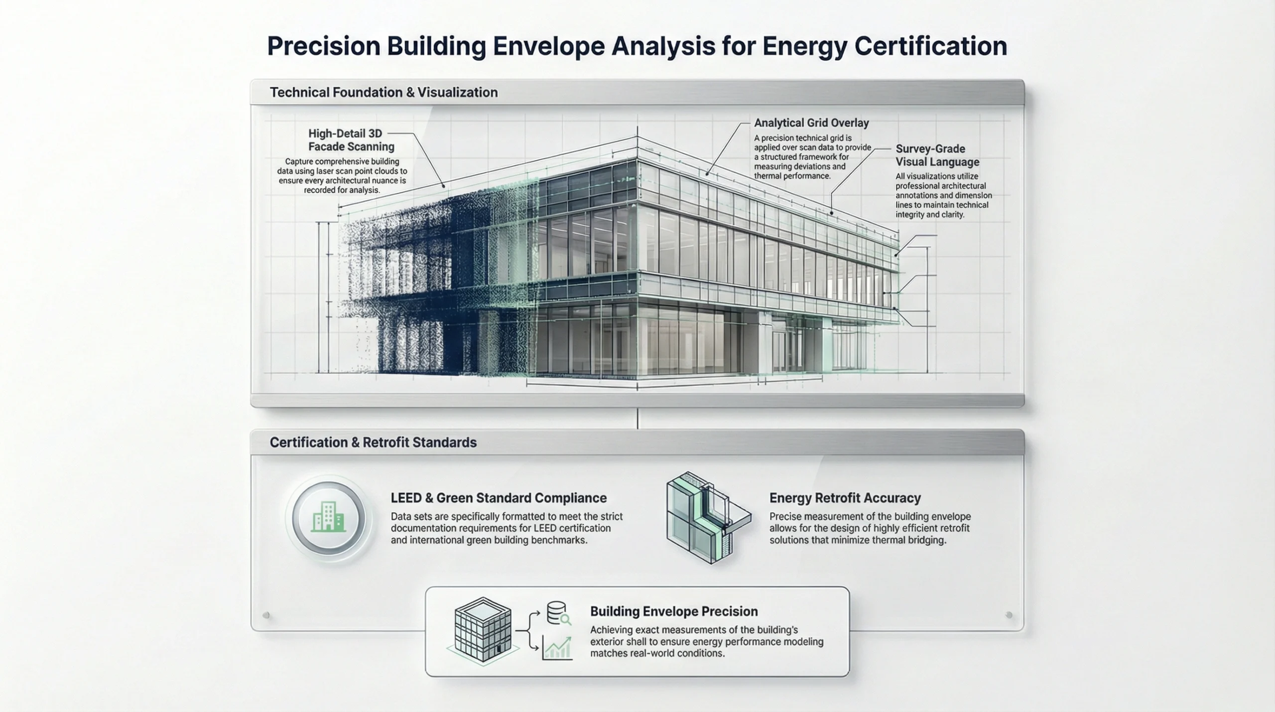
3D laser scanning provides the geometric accuracy required for energy modeling and retrofit planning.

Without reliable as-built data, performance gaps emerge between design and constructed reality.

Embodied Carbon and Material Efficiency

Embodied carbon is generated during:

  • Manufacturing
  • Transportation
  • Installation
  • Replacement due to errors

If inaccurate surveys cause materials to be replaced or modified, the carbon impact doubles.

Sustainable surveying in Vancouver reduces this risk by ensuring contractor estimates and material procurement are based on verified dimensions.

Precision reduces rework. Reduced rework lowers embodied emissions.

Carbon reduction process enabled by accurate sustainable surveying and reduced construction rework

How 3D Laser Scanning Reduces Environmental Impact

1. Fewer Site Visits

Traditional workflows often require:

  • Initial measurement visit
  • Follow-up visits to confirm missed dimensions
  • Additional coordination visits

A single comprehensive scan captures complete spatial data. The project team can revisit the site virtually through the point cloud or BIM model.

Fewer vehicle trips mean lower operational carbon emissions.

2. Reduced Site Disruption

Laser scanning is non-contact and non-invasive. It requires:

  • Minimal physical intrusion
  • No demolition
  • No surface damage

This is particularly important in:

  • Occupied buildings
  • Heritage structures
  • Sensitive ecological sites

3. Digital Twin for Long-Term Asset Management

The output of sustainable surveying is often a digital twin – a precise virtual replica of the building.

Digital twins support:

  • Lifecycle maintenance planning
  • Energy monitoring integration
  • Space optimization
  • Future retrofit planning

Extending a building's usable life is one of the most effective carbon reduction strategies available.

LEED and Green Building Documentation in BC

For developers pursuing LEED certification, defensible documentation is mandatory.

Sustainable surveying supports:

  • Building Life-Cycle Impact Reduction credits
  • Accurate site analysis
  • Envelope verification
  • Indoor environmental quality coordination

Scan-to-BIM workflows embed measurable data directly into the model, allowing energy consultants and engineers to work from verified geometry.

In a regulatory environment like Vancouver's, documentation accuracy directly affects compliance.

LEED and green building documentation supported by sustainable surveying in Vancouver

BOMA Standards and Space Optimization

In commercial real estate, sustainability also means maximizing existing space before building new.

Laser-based measurement allows:

  • BOMA-compliant area calculations
  • Accurate rentable area verification
  • Identification of underutilized square footage

Optimizing existing assets reduces pressure for new construction, which carries significant embodied carbon.

Heritage Conservation and Adaptive Reuse

Vancouver's heritage inventory represents embodied carbon already invested decades ago.

Demolition wastes that carbon.

Sustainable surveying enables adaptive reuse by documenting complex, irregular structures without invasive measurement methods.

3D scanning can capture:

  • Warped walls
  • Uneven floors
  • Ornamental facades
  • Historical detailing

This precision encourages retention over demolition.

The greenest building is often the one that already exists.

Heritage renovation and adaptive reuse supported by sustainable surveying in Vancouver

Modern Tools for Eco-Friendly Measuring in Greater Vancouver

LiDAR and Terrestrial Laser Scanning

Millimeter-accurate interior and exterior capture with minimal disruption.

Drone-Based Surveying

Ideal for roofs, facades, and large sites without scaffolding or heavy access equipment.

Scan-to-BIM Workflows

Conversion of raw point clouds into intelligent 3D models for energy analysis, retrofit coordination, and lifecycle planning.

These tools collectively reduce field time, minimize rework, and support long-term sustainability goals.

Business Case for Sustainable Surveying

Environmental responsibility must align with financial logic.

Sustainable surveying in Vancouver delivers:

  • Reduced change orders
  • More accurate contractor bids
  • Faster permit approvals
  • Improved client confidence
  • Lower lifecycle costs

In high-value markets like Greater Vancouver, precision protects both margin and reputation.

Selecting a Green Documentation Partner

When evaluating a surveying partner, consider:

  • Technology capabilities (LiDAR, SLAM, drone integration)
  • Experience with LEED and high-performance buildings
  • Knowledge of Vancouver Building By-law requirements
  • Ability to deliver both 2D CAD and BIM outputs
  • Quality control processes

Sustainability is not just about tools – it is about disciplined execution.

Conclusion: Sustainability Begins with Accurate Data

Vancouver's path to carbon reduction depends on smarter construction practices at every stage.

Sustainable surveying is not a marketing term. It is a measurable reduction in waste, emissions, and risk.

By integrating 3D laser scanning, digital twins, and rigorous documentation standards, project teams can:

  • Reduce embodied carbon
  • Improve material efficiency
  • Support regulatory compliance
  • Extend building lifespans

Precision is environmental responsibility.

In a city committed to climate leadership, the future of construction begins with accurate measurement.

Commercial Property Management Vancouver: Digital Strategy 2026

The commercial real estate landscape in British Columbia is undergoing a profound transformation, driven by technological integration and shifting market demands. For stakeholders navigating commercial property management in Vancouver, the era of relying on static, paper-based records is rapidly closing. As we move through 2025 and into 2026, the convergence of high-precision digital documentation, artificial intelligence (AI), and advanced PropTech is redefining how assets are built, maintained, and leased. Property owners and agents must now leverage data accuracy not just for operational efficiency, but as a critical strategy for asset valuation and risk mitigation.

In the competitive arena of commercial property management in Vancouver, the margin for error regarding square footage, lease administration, and compliance is disappearing. The integration of digital tools is no longer a luxury; it is a necessity for maximizing ROI and ensuring long-term viability. This article explores how the revolution in digital documentation – from 3D laser scanning services to AI-driven analytics – is reshaping the industry, providing a roadmap for professionals to stay ahead in Vancouver's dynamic market.

The digital paradigm shift in commercial property management in Vancouver

The economic indicators for the coming years suggest a market that is stabilizing yet demanding greater adaptability from landlords and operators. As inflation remains manageable and interest rates stabilize, the focus in commercial property management in Vancouver is shifting from crisis response to sustainable growth and strategic foresight. However, this stability does not imply stagnation; rather, it highlights a bifurcation in asset performance where technologically advanced, data-rich properties outperform legacy assets.

Digital transformation is moving beyond mere adoption to deep integration. Successful property managers are connecting disparate tools into seamless operational ecosystems where finance, leasing, and facilities management communicate through a single framework. At the heart of this ecosystem lies accurate data. Without precise physical data regarding a building's existing conditions, even the most sophisticated management software cannot function at optimal capacity.

For commercial property management in Vancouver, this means the digitization of physical assets is the first step toward modernization. The ability to visualize and analyze portfolio performance through digital twins and accurate datasets enables managers to anticipate market changes and align operational models accordingly. This level of strategic agility is essential in a market where tenant priorities are shifting toward flexibility, sustainability, and tech-enabled spaces.

The role of accurate floor plans in asset valuation

One of the most persistent challenges in real estate is the discrepancy between historical blueprints and the current reality of a built environment. Renovations, unrecorded alterations, and legacy errors often mean that the leasable area on paper does not match the physical asset. In the realm of commercial property management in Vancouver, establishing accurate floor plans is the baseline for revenue assurance.

Digitizing static blueprints into searchable, collaborative digital records is critical for maximizing the value of square footage. Precise measurements ensure that common area maintenance (CAM) charges are allocated correctly and that landlords are capturing the full revenue potential of their gross leasable area. Furthermore, in an environment where regulatory compliance regarding building safety and environmental reporting is tightening, having verifiable spatial data is a requisite for risk management.

Leveraging 3D laser scanning services for precision

To achieve the level of accuracy required for modern commercial property management in Vancouver, industry leaders are turning to 3D laser scanning services. Technologies such as LiDAR (light detection and ranging) and high-fidelity scanners like the Trimble X12 or Matterport Pro3 capture millions of data points to create an exact digital replica of a property.

3D laser scanning of commercial buildings in Vancouver for accurate digital documentation

From physical to digital: the scan-to-BIM workflow

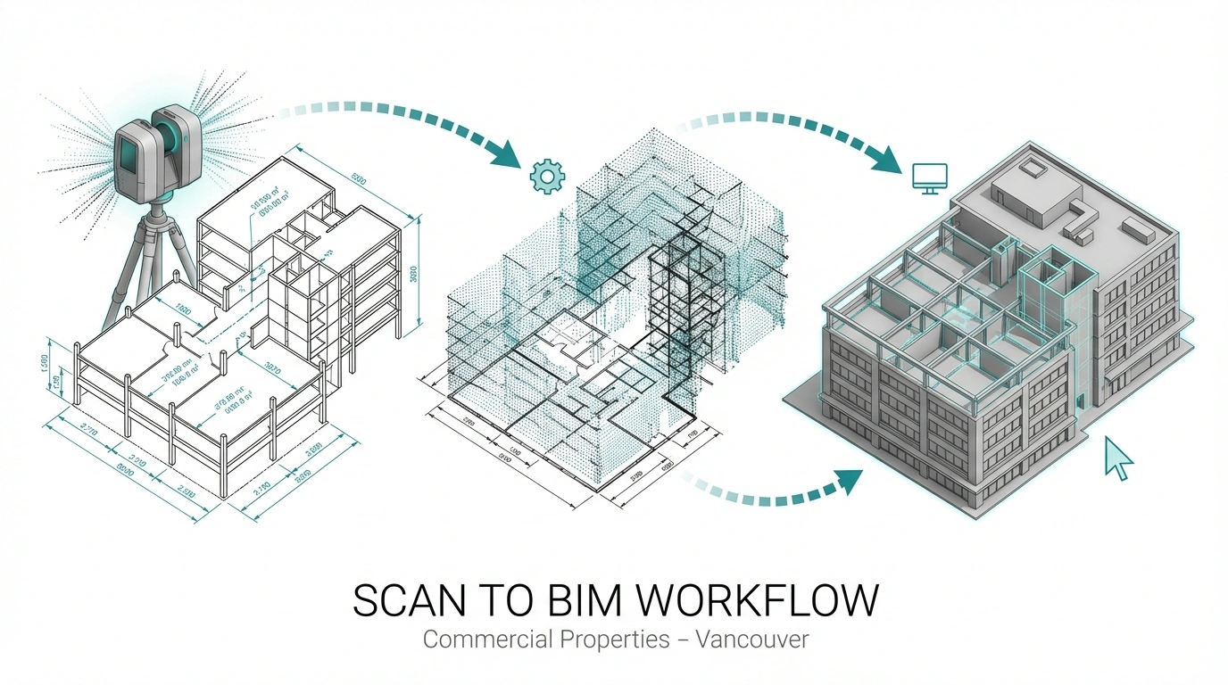
The application of 3D laser scanning services facilitates a "scan-to-BIM" (building information modeling) workflow. This process converts point cloud data into detailed 3D models that serve as a single source of truth for architects, engineers, and facility managers. For commercial property management in Vancouver, this technology offers immediate benefits:

  • As-built verification: it provides a definitive record of existing conditions, eliminating the guesswork often associated with older Vancouver stock, particularly in heritage or retrofitted buildings.
  • Conflict detection: by identifying structural anomalies or mechanical clashes digitally before renovation begins, owners avoid costly change orders during construction.
  • Virtual access: stakeholders can tour and inspect properties remotely, a capability that enhances decision-making speed and reduces travel costs for investors and dispersed teams.

The adoption of these technologies aligns with broader industry trends where investors prioritize solutions that deliver immediate operational efficiencies and measurable ROI. By utilizing 3D laser scanning services, property managers in Vancouver ensure they are working with data that meets professional-grade standards, essential for high-stakes commercial developments.

Scan-to-BIM workflow supporting commercial property management and renovation planning

Streamlining renovation planning and execution

Vancouver's commercial sector is currently seeing a "flight to quality," where tenants gravitate toward premium, modern office spaces, leaving older class B and C buildings to struggle with higher vacancy rates. To remain competitive, commercial property management in Vancouver must prioritize strategic renovations. Renovation planning based on precise digital documentation significantly reduces the risks associated with retrofitting existing structures.

Integrating construction documentation

Successful repurposing of commercial space relies heavily on the quality of construction documentation. When a property manager or owner possesses a digital twin of their asset, generating detailed building permit drawings becomes a streamlined process. This is particularly relevant in Vancouver, where adherence to the BC building code and municipal bylaws regarding seismic upgrades and energy efficiency is strictly enforced.

Digital tools allow for the rapid creation of:

  • Reflected ceiling plans (RCP): critical for lighting and HVAC upgrades.
  • Electrical and power plans: essential for modern tenants with high power requirements, such as tech firms or data centers.
  • Egress and safety plans: ensuring compliance with fire codes and safety regulations.

By maintaining up-to-date construction documentation, property managers can expedite the permitting process, reducing the downtime between tenancies and accelerating the time-to-revenue for renovated units.

Empowering industry professionals: architects and designers

The revolution in commercial property management in Vancouver is also redefining the relationship between property managers and the design professionals they hire. Providing architects and interior designers with high-quality digital assets enables them to work more effectively.

Advanced interior designer tools

For creative professionals, interior designer tools are only as good as the base data they utilize. When property managers provide accurate floor plans generated from laser scans, designers can:

  • Visualize spatial relationships accurately in 3D.
  • Plan fit-outs that maximize space utilization for hybrid work models.
  • Create immersive visualizations for prospective tenants, helping them envision their brand in the space before a lease is signed.

Sharpening contractor estimates

Unforeseen conditions are the primary cause of budget overruns in construction. By providing contractor estimates based on verified existing conditions rather than outdated drawings, property managers can secure more accurate pricing. This transparency builds trust between owners and contractors and ensures that capital expenditure budgets are adhered to. In commercial property management in Vancouver, where construction costs remain high, this level of fiscal control is invaluable.

Integrating PropTech for operational excellence

The data gathered through scanning and documentation does not sit in a silo; it fuels the next generation of property management software. Platforms like Yardi, MRI Software, and Buildium are evolving to integrate this physical data into their operational workflows.

The intersection of AI and property management

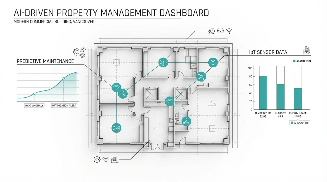
Artificial intelligence is playing an increasingly pivotal role in commercial property management in Vancouver. AI tools are being used to structure data from documents, generate property marketing materials, and transform the request-for-proposal process. More importantly, AI-driven predictive analytics can utilize data from building sensors and digital models to anticipate maintenance requirements months in advance.

For example, connecting IoT (internet of things) sensors to a digital building model allows managers to monitor energy usage and equipment health in real-time. This moves maintenance strategies from reactive to predictive, significantly reducing emergency repair costs and extending the lifespan of building assets.

AI predictive maintenance connected to a digital property model in Vancouver

Enhancing tenant experience and retention

In a market where tenant expectations are rising, the digital experience is a key differentiator. Tenants now demand seamless, tech-enabled interactions with their property managers. Commercial property management firms in Vancouver are utilizing self-service portals and mobile apps that allow tenants to:

  • Submit maintenance requests.
  • View lease documents and real estate floor plans.
  • Book amenities and manage visitor access.

Transparency is critical. Detailed service charge statements and real-time updates build trust and improve retention rates. By using software that integrates real estate floor plans and lease data, managers can provide precise, itemized breakdowns of costs, which is essential for maintaining tenant satisfaction in a competitive leasing market.

Future-proofing assets in the greater Vancouver market

The Vancouver market faces unique challenges, including land constraints, strict zoning, and a focus on sustainability. Commercial property management in Vancouver must be forward-looking, anticipating trends such as the conversion of underutilized office space into residential or mixed-use developments.

Adaptive reuse and mixed-use developments

As the office market recalibrates, converting commercial spaces to meet the surging demand for housing is a topic of intense discussion. However, conversion is complex. Only a small percentage of office buildings are prime candidates for conversion due to floor plate depths and plumbing constraints. High-quality as-built documentation is the first step in assessing the feasibility of such projects, allowing architects to analyze the structure's potential for home renovation projects in greater Vancouver within a commercial context.

Sustainability and compliance

With Vancouver's focus on green buildings and the "net zero" initiatives, property managers must track and report on ESG (environmental, social, and governance) metrics. Digital documentation supports this by providing the data needed to calculate carbon footprints and plan energy retrofits. Commercial property management in Vancouver is increasingly judged by operational efficiency and ESG compliance, making data accuracy a cornerstone of asset value.

Strategic advantages of digital documentation

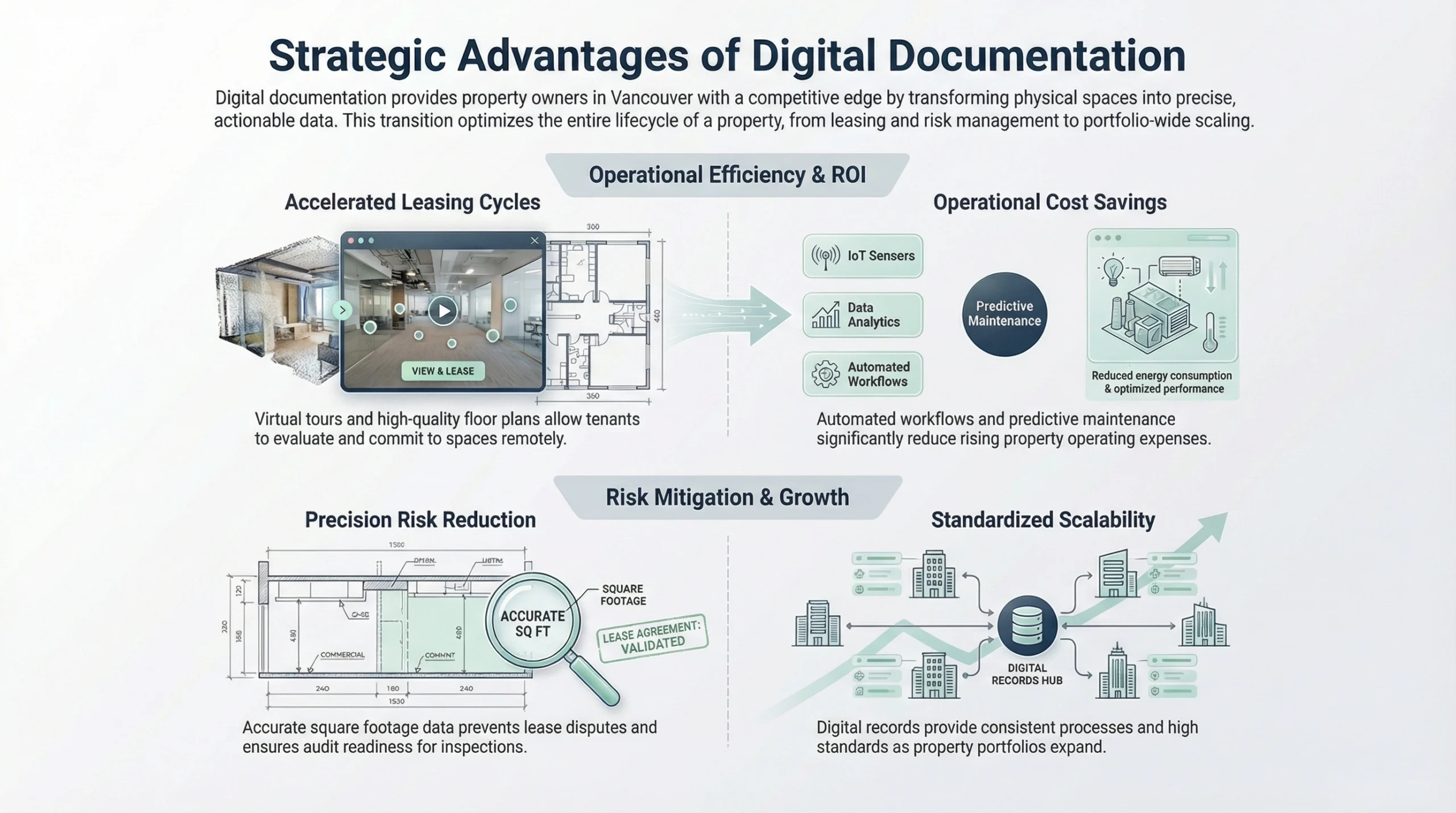
For owners and property managers in Vancouver, investing in digital documentation offers distinct strategic advantages:

  1. 1. Accelerated leasing cycles: high-quality real estate floor plans and virtual tours allow prospective tenants to evaluate spaces remotely, speeding up the decision-making process.
  2. 2. Risk reduction: accurate data mitigates the risk of lease disputes over square footage and ensures readiness for audits and inspections.
  3. 3. Scalability: as portfolios grow, having standardized digital records ensures consistent processes and high standards across all operations.
  4. 4. Cost savings: automated workflows and predictive maintenance reduce operational costs, a crucial factor as operating expenses continue to rise.
Impact of digital documentation on commercial property ROI and operating efficiency

Conclusion: the digital thread of value

The revolution in commercial property management in Vancouver is not merely about adopting new gadgets; it is about establishing a "digital thread" of value that runs through the entire lifecycle of an asset. From the initial 3D laser scanning services that capture the reality of the built environment to the AI-driven software that manages daily operations, accurate data is the currency of modern real estate.

By embracing accurate floor plans, detailed construction documentation, and integrated PropTech solutions, property managers can transform their operations from reactive to proactive. They can empower their partners with better interior designer tools and contractor estimates, ensuring projects are delivered on time and on budget.

As Vancouver continues to evolve as a global hub for commerce and technology, the buildings that thrive will be those managed with intelligence, precision, and a commitment to digital excellence. For stakeholders in commercial property management in Vancouver, the message is clear: the future belongs to those who measure, document, and manage with digital precision.

Book Measurements Get a Quote