As-Built Documentation for Property Acquisitions
Quick answer
Property due diligence documentation gives acquisition teams a measured record of what physically exists in a building before closing. An as-built survey can verify layouts, dimensions, floor areas, circulation, major architectural features and other visible existing conditions, then convert that field data into floor plans, elevations, sections, DWG/PDF drawings, a point cloud or a Revit/BIM model. It complements, rather than replaces, legal, environmental, structural and property condition assessments.
A property acquisition can include extensive legal, financial and technical review while still relying on drawings that no longer match the building. For architects, developers, owners and lenders, current as-built documentation closes that spatial information gap. It creates a measured baseline that can be compared with leases, seller records, renovation assumptions and future design requirements before the transaction moves into execution.
Where property due diligence documentation fits in an acquisition
As-built documentation is the physical-geometry layer of property due diligence. Commercial acquisition checklists commonly include title and ownership records, zoning and approvals, environmental reports, leases, operating information, permits, engineering records and existing drawings. The as-built survey does not replace those reviews; it gives the deal team a current spatial record that can be checked against them when the seller’s plans are incomplete, outdated or inconsistent with the building.
Acquisition takeaway
- Use existing seller drawings as reference material, not automatically as a verified record of current conditions.
- Order measured documentation when layout, area or renovation assumptions materially affect underwriting or post-closing plans.
- Define the required deliverables before the site visit so the survey captures the geometry needed by the acquisition, design and facilities teams.
- Keep condition assessment and as-built measurement as separate scopes unless qualified specialists have explicitly been retained for both.
The main value is discrepancy detection. A current plan can reveal where demising walls, rooms, openings or circulation paths differ from legacy drawings. Those differences may affect leasing analysis, tenant improvements or renovation planning. A measured drawing set also gives consultants a shared base file instead of forcing each discipline to reconstruct the building independently.
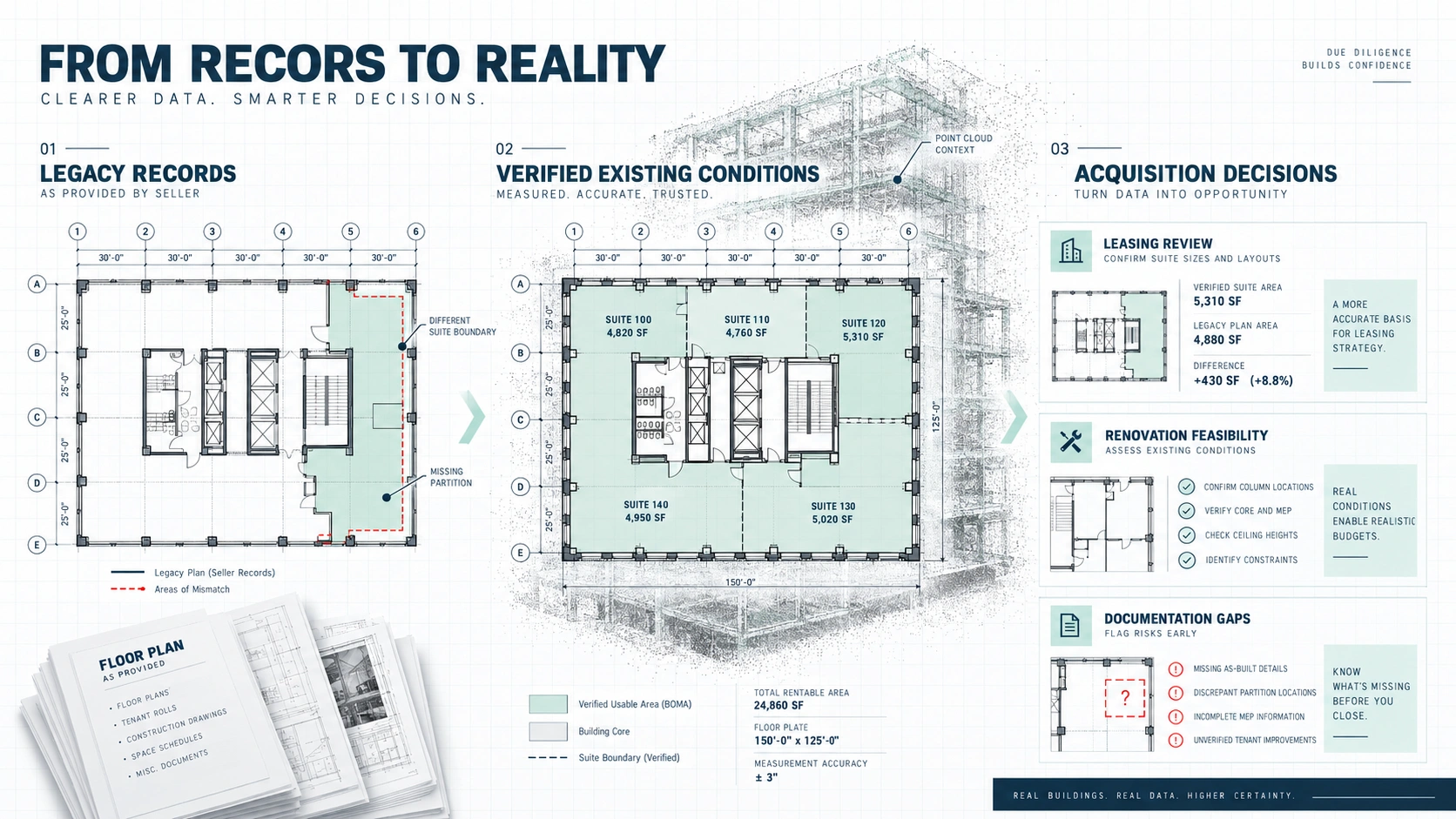
Treat as-built documentation as a verified spatial baseline for the transaction. It is most useful when decisions depend on what is physically present, not only on what older records say should be present.
What an as-built survey can verify before purchase
A building survey before purchase can verify measurable existing conditions that are visible and accessible within the agreed scope. Typical outputs document room and corridor geometry, walls, columns, openings, stairs, ceiling features, exterior geometry and selected site elements. The capture scope should follow the questions the acquisition team needs answered rather than defaulting to a generic drawing package.
Existing layout and dimensional consistency
Current floor plans make it easier to compare actual layouts with archived construction drawings, leasing plans and renovation records. If a commercial suite has been reconfigured, the latest seller PDF may describe an earlier condition. New measurements establish which partitions, openings and circulation paths exist now.
Area and lease-space verification
As-built drawings for property acquisition can support area checks by defining the boundaries from which calculations are made. For commercial leasing, a BOMA-based area calculation may be appropriate when the transaction or lease analysis specifically requires rentable or usable area under an agreed BOMA methodology. The measurement standard, boundary rules and calculation basis should be stated explicitly so a buyer does not compare unlike area figures.
Geometry for renovation or repositioning
Acquisition teams planning immediate renovation need more than a marketing floor plan. Architects may require wall geometry, elevations, sections, reflected ceiling plans and vertical relationships; BIM workflows may require a point cloud and Revit model at an agreed level of development. Capturing those requirements during due diligence can reduce the need for a second survey after closing.
What as-built documentation does not verify
An as-built survey records geometry; it is not, by itself, a property condition assessment, structural assessment, environmental investigation, code opinion or legal survey. A property condition assessment examines building systems and observed deficiencies, while specialist engineering may be required for structural, envelope, mechanical or electrical concerns. Acquisition teams should use each scope for the question it is designed to answer.
How 3D laser scanning becomes acquisition-ready documentation
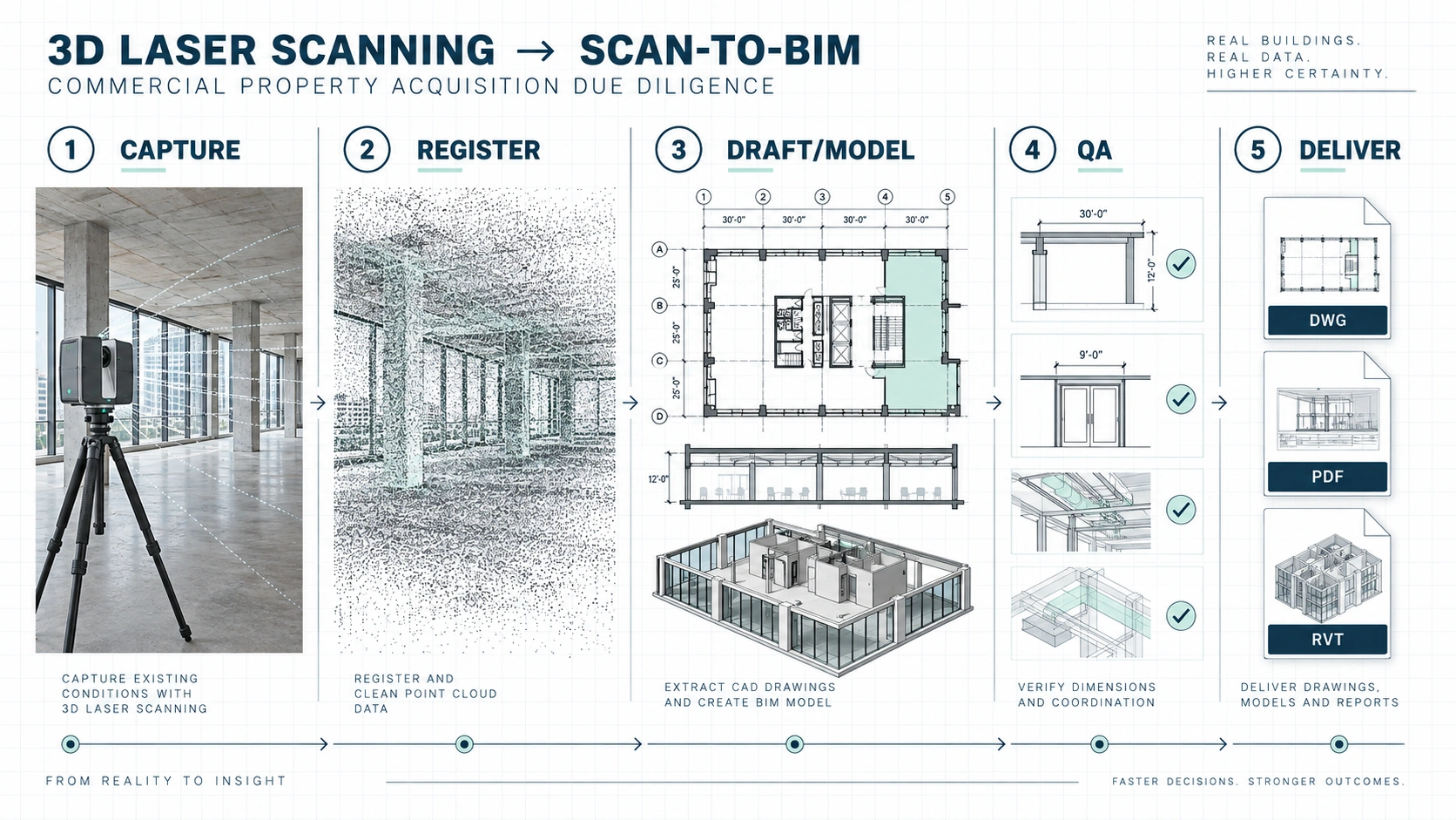
3D laser scanning is useful when a property has complex geometry, multiple levels, dense interior layouts or a high downstream need for CAD/BIM reuse. LiDAR captures spatial observations from many scanner positions and combines them into a registered point cloud. The point cloud is then interpreted and drafted into the deliverables specified for the transaction, rather than being treated as the final answer by itself.
- Scope the transaction questions: define areas to capture, access constraints, required drawing views, file formats and intended downstream uses.
- Capture existing conditions: scan accessible spaces and collect supporting field observations needed to interpret the geometry.
- Register and review the point cloud: align scan positions into a coordinated dataset and check coverage before drafting.
- Produce drawings or models: create floor plans, elevations, sections, reflected ceiling plans or a Revit/BIM model to the agreed scope.
- Run QA and deliver: review key dimensions, naming, levels, sheet organization and file outputs before issuing DWG, PDF, RVT and/or point-cloud files.
The survey specification matters as much as the capture technology. A point cloud may contain more spatial information than the due diligence team needs, while a minimal floor-plan scope may omit elevations, ceiling geometry or structural context needed for redevelopment. Work backward from the acquisition decision and post-closing design workflow, then define capture and modeling detail accordingly.
Choose the survey scope from the decisions the team must make. Laser scanning is the capture method; the useful transaction output is a controlled drawing, model or area dataset built from that capture.
Which deliverables answer which due diligence questions
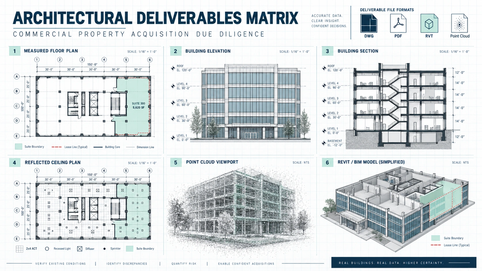
Different deliverables answer different acquisition questions, so requesting every possible output is rarely necessary. A property manager validating suite layouts may need measured floor plans and area schedules, while a developer evaluating a major repositioning may need sections, elevations, a point cloud and a Revit model. Matching the deliverable to the decision keeps the scope efficient and makes handoff after closing more useful.
| Deliverable | Best used for | Typical acquisition question |
|---|---|---|
| Measured floor plans | Layouts, dimensions, circulation, suite boundaries | Does the current building configuration match the records we received? |
| Elevations and sections | Vertical geometry, facade context, level relationships | What existing geometry will constrain renovation or redevelopment? |
| Reflected ceiling plans | Ceiling grids, visible fixtures and overhead coordination | What ceiling conditions should the tenant-improvement team inherit? |
| Point cloud | Dense spatial reference and consultant reuse | Do we need a reusable measured dataset for later design verification? |
| Revit/BIM model | Coordinated design workflows and spatial planning | Will the post-closing team design directly from a model? |
| DWG and PDF | CAD production, review, markups and record packages | Which formats can every consultant and decision-maker use immediately? |
| Area calculations | Commercial leasing and square-footage review | Which measurement rules and boundaries support the reported area? |
LOD should be specified deliberately for BIM deliverables. Early feasibility may need only a simple model, while immediate architectural or engineering work may justify more detail. MeasureBuilt projects can be scoped across LOD 100–300 depending on intended use, but model content should be defined element by element rather than assumed from an LOD label.
When as-built documentation is most useful during acquisitions
Multi-tenant commercial properties
Multi-tenant assets benefit from current suite and common-area geometry because leasing information depends on clearly understood premises boundaries. When rent rolls, lease plans and physical partitions do not align, a measured base can help the acquisition team isolate where a discrepancy exists and which document needs further review. BOMA calculations belong here only when the deal requires commercial area verification under a defined methodology.
Industrial and mixed-use buildings
Industrial and mixed-use properties often combine large open areas with mezzanines, service zones, offices, loading areas and equipment interfaces. Existing drawings may have been updated unevenly across decades of alterations. Laser scanning can consolidate accessible geometry into one coordinate-based dataset, supporting feasibility studies, equipment planning and future CAD/BIM work after acquisition.
Properties planned for immediate renovation
A buyer planning tenant improvements, conversion or repositioning can use due diligence to create the design base before ownership transfers. The survey can be scoped for floor plans, elevations, sections, reflected ceiling plans or a Revit model. That turns transaction documentation into a usable existing-conditions package for the project.
Older, heritage or repeatedly altered buildings
Older buildings deserve particular attention when archived drawings are incomplete or multiple renovations have changed the original geometry. A scan-based survey documents the accessible current condition without assuming that the original record set is still accurate. For heritage work, that spatial record can support later design and conservation coordination, while heritage evaluation and regulatory decisions remain separate professional scopes.
How to verify building square footage before buying
To verify building square footage before buying, first define which area the transaction is actually discussing. Gross building area, measured interior area, usable area and rentable area are not interchangeable. A number in an offering memorandum, lease abstract or legacy plan cannot be checked meaningfully until the team identifies the measurement basis, the boundaries included and the purpose of the figure.
- Identify the area figure being relied on in underwriting, leasing or valuation.
- Confirm the measurement convention or contractual definition behind that figure.
- Measure the relevant existing boundaries and document assumptions or inaccessible areas.
- Recalculate the required area using the agreed rules, including BOMA methodology only where commercial leasing or square-footage verification calls for it.
- Log discrepancies for review by the appropriate deal, legal, valuation or leasing professionals rather than treating a measurement difference as a standalone conclusion.
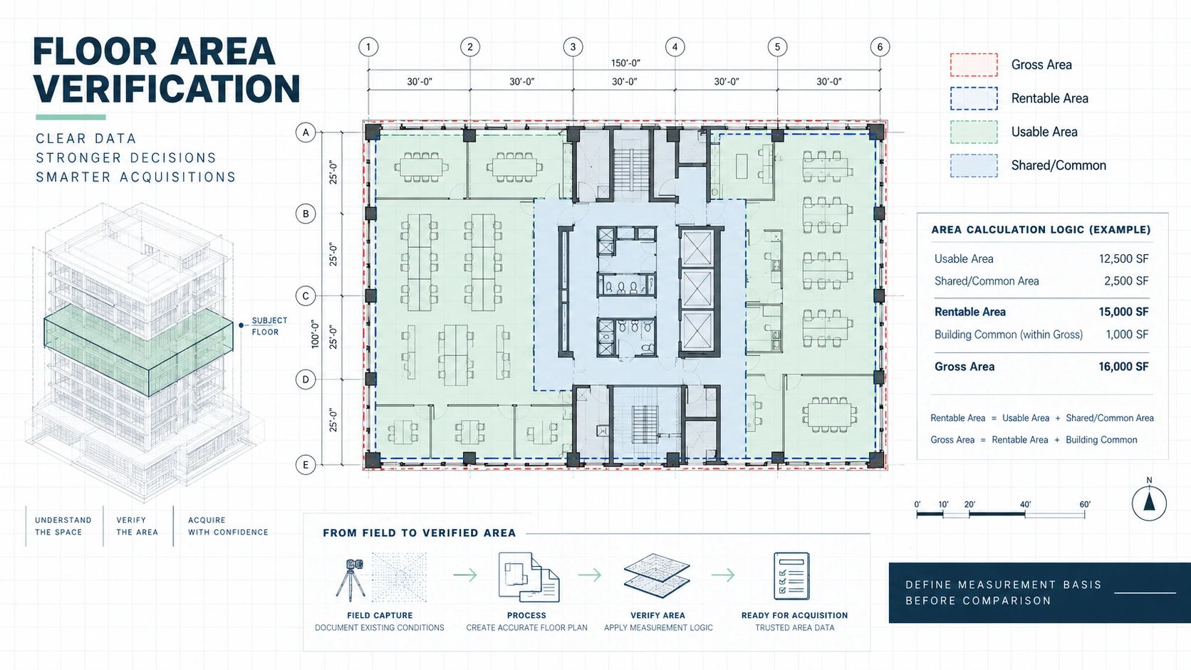
A square-footage discrepancy is a prompt for reconciliation, not an automatic statement about value or legal rights. The acquisition team may need to compare measured geometry with leases, title information, appraisal assumptions or seller representations. The survey provider should clearly identify the geometry measured and the calculation basis so other professionals can determine the transaction implications.
Provider-selection checklist for an acquisition survey
A due diligence survey provider should be selected on scope clarity and downstream usability, not only on scanning equipment. The provider needs to understand which acquisition questions must be answered, what the design team will need after closing and how uncertainties will be documented. A clear proposal should separate capture, drafting, modeling, area calculations and any excluded specialist assessment.
- Scope: The proposal identifies buildings, floors, suites, exterior areas and inaccessible zones to be included or excluded.
- Technology: The capture method is appropriate for the property’s scale, geometry, access and required outputs.
- Deliverables: Floor plans, elevations, sections, reflected ceiling plans, site plans, point cloud, DWG, PDF or RVT are named explicitly.
- BIM detail: Revit model content and any LOD 100–300 requirement are defined by intended use rather than by a vague modeling label.
- Area method: Any square-footage calculation states the measurement basis and uses BOMA only when the commercial leasing context requires it.
- Quality control: The provider explains how registration, dimensions, levels and drawing outputs are reviewed before delivery.
- Handoff: Files are organized so architects, contractors, property managers and acquisition teams can reuse them after closing.
- Boundaries of service: The provider distinguishes as-built measurement from structural, environmental, legal, code and property condition opinions.
The right provider delivers a usable existing-conditions record with a clearly defined scope. The scanner is only one part of the workflow; QA, drafting standards, file structure and downstream compatibility determine whether the data remains useful.
From due diligence capture to a reusable building record
The strongest acquisition survey remains useful after closing. The same measured baseline can support design feasibility, tenant improvements, facilities planning and contractor pricing when the original scope captures enough geometry. Acquisition teams should involve the likely post-closing architect, project manager or facilities lead when defining deliverables.
The MeasureBuilt approach
MeasureBuilt structures the workflow around the required output: scan the accessible existing conditions, register the point cloud, produce the agreed drawings or model, complete QA, and deliver the package in formats such as DWG, PDF and RVT. For projects in Greater Vancouver and the Lower Mainland, the scope can be tailored to acquisition review, renovation planning or continued building documentation.
- Scan: capture the accessible geometry required by the agreed scope.
- Point cloud: register the field data into a coordinated spatial reference.
- Drawings/model: produce floor plans, elevations, sections, RCPs or Revit/BIM content as required.
- Delivery: issue the agreed DWG, PDF, RVT and/or point-cloud files for the deal team and downstream consultants.
For acquisition work, the key is timing the survey early enough that findings can still influence the decision process. If the buyer waits until after closing, measured documentation becomes a design-start task rather than a due diligence tool. When geometry, area or redevelopment feasibility matters to the transaction, define the survey scope alongside the broader commercial real estate due diligence checklist.
As-built documentation gives acquisition teams a measured, reusable record of existing building geometry and helps reconcile physical conditions with seller drawings, leasing information and redevelopment assumptions. It is most effective when scoped around specific transaction questions and coordinated with the separate legal, environmental, structural and property condition reviews required for the asset. Request a quote at measurebuilt.com/request-a-quote to get a fixed price and timeline for your as-built survey.
FAQ
Are as-built drawings required for every property acquisition?
No. The need depends on the property, available records and the decisions being made during due diligence. As-built drawings are especially useful when existing plans are missing, outdated or inconsistent, when square footage affects leasing analysis, or when the buyer expects immediate renovation. The acquisition team should order only the documentation needed to resolve material spatial questions.
Can an as-built survey replace a property condition assessment?
No. An as-built survey documents measurable existing geometry, while a property condition assessment evaluates the physical condition of building systems and observed deficiencies. Structural, environmental, envelope, MEP and code questions may require separate qualified specialists. The scopes can support one another, but they answer different due diligence questions.
What files should a buyer request from an as-built survey?
The files should match the intended use. PDF and DWG are practical for review and CAD workflows; a point cloud preserves dense measured spatial data; RVT is useful when the post-acquisition design team will work in Revit. Floor plans are the core deliverable for many transactions, with elevations, sections, RCPs and site plans added when the project needs them.
Can 3D laser scanning help verify building square footage?
Yes, when the survey scope includes the boundaries required for the area calculation. The team must still define what area is being measured and which rules apply. For commercial leasing, BOMA methodology may be appropriate when specifically required. The final area should identify its calculation basis so it can be compared correctly with leases, seller records or underwriting assumptions.
When should the as-built survey happen during due diligence?
The survey should happen early enough for discrepancies to be reviewed before key transaction decisions are locked. If current geometry may affect area, renovation feasibility, tenant planning or capital assumptions, the buyer benefits from having the measured base while the broader diligence process is still active. Site access, required outputs and consultant needs should be confirmed before field capture.