Point Cloud Services Vancouver: After 3D Laser Scanning
Point cloud services Vancouver help convert 3D laser scan data into usable building documentation. After a 3D laser scan, clients may receive registered point cloud files, floor plans, CAD drawings, Revit models,…
Quick Answer
Point cloud services Vancouver help convert 3D laser scan data into usable building documentation. After a 3D laser scan, clients may receive registered point cloud files, floor plans, CAD drawings, Revit models, elevations, sections, or BIM documentation. The point cloud becomes the measured digital reference used to document existing conditions before renovation, design coordination, contractor pricing, or facility planning.
Executive Summary
Point cloud services in Vancouver start after a building is captured with 3D laser scanning. The scanner records visible site conditions as millions of measured points, creating a digital dataset called a point cloud. This point cloud can then be registered, cleaned, reviewed, and converted into practical deliverables such as point cloud files, PDF floor plans, DWG CAD drawings, Revit models, IFC files, elevations, sections, reflected ceiling plans, and as-built documentation. For Vancouver renovations, commercial tenant improvements, industrial facilities, older buildings, and complex properties, point cloud services help architects, contractors, designers, owners, and facility managers work from current existing conditions instead of outdated drawings. The practical takeaway is simple: the scan is only the beginning. The real value comes from choosing the right point cloud deliverables for the project workflow.
Point Cloud Services in Vancouver: What You Get After a 3D Laser Scan
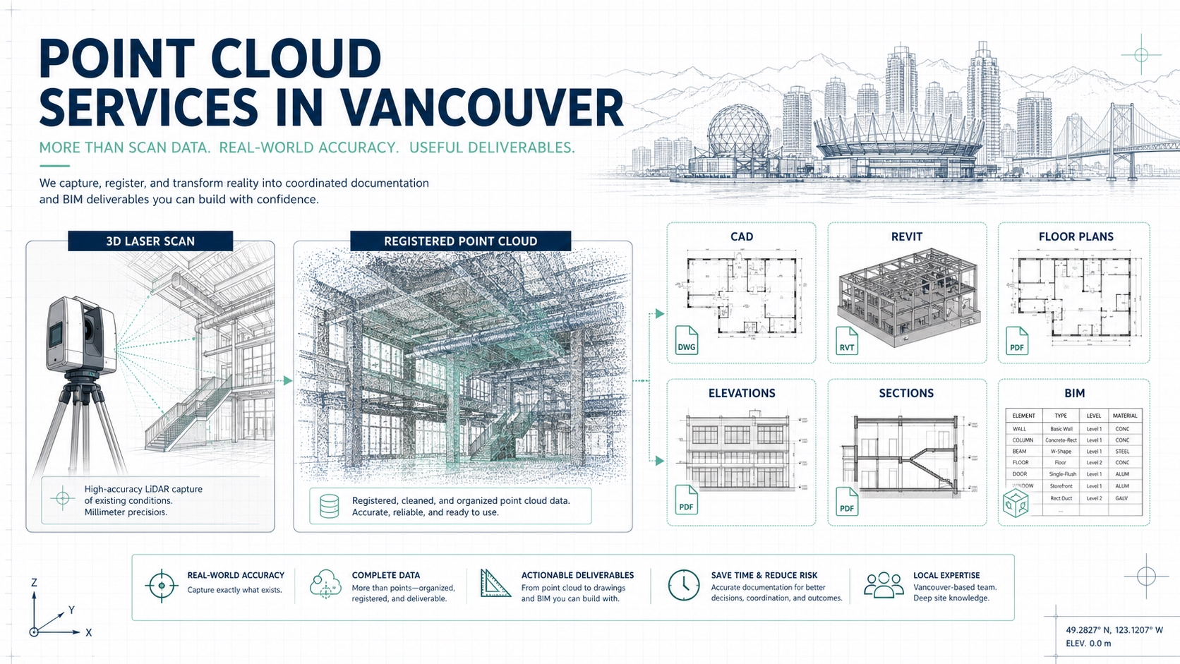
What Point Cloud Services Vancouver Means After a 3D Laser Scan
Point cloud services Vancouver refers to the processing and conversion of 3D laser scan data into useful building documentation. A 3D laser scanner captures visible surfaces inside or outside a building, and the resulting point cloud becomes a measured digital reference of existing conditions. This reference can support floor plans, CAD drawings, Revit models, elevations, sections, and digital building records. The practical rule is that a point cloud is not the final answer by itself; it is the measured base for the deliverables your project team needs.
A point cloud is a collection of measured points that represent visible building geometry. These points can show walls, floors, ceilings, stairs, openings, columns, rooflines, façade elements, exposed structure, and visible building systems depending on scan coverage. For renovation and documentation projects in Vancouver, point clouds are useful because many buildings no longer match old drawings. The practical takeaway is to use point cloud data when current site conditions matter more than historical assumptions.
Point cloud services are different from basic 3D scanning because the service continues after the scan is complete. The scan captures the raw site data, but the point cloud still needs registration, organization, quality review, and often conversion into CAD or BIM deliverables. A client may not be able to use a raw point cloud without technical software or drafting support. Before ordering point cloud services, clients should define whether they need the data itself, processed drawings, Revit models, or a full as-built package.
What a Client Gets After a 3D Laser Scan
After a 3D laser scan, a client may receive a registered point cloud, a drawing package, a BIM model, or a combination of deliverables. The exact package depends on the project scope, software requirements, building complexity, and how the documentation will be used. A property owner may need PDF floor plans, while an architect may need DWG files or a Revit model. The practical recommendation is to confirm deliverables before the site visit, not after the scan is complete.
A registered point cloud is usually the first technical output after scanning. Individual scan positions are aligned into one coordinated dataset so the building can be viewed and measured as a complete environment. This registered point cloud may be delivered in formats such as E57, RCP, RCS, LAS, LAZ, or other project-specific formats depending on software and provider workflow. Clients should ask which point cloud format is included and whether the design team can open it.
A processed documentation package may include drawings and models created from the point cloud. Common outputs include PDF floor plans, DWG CAD files, elevations, sections, reflected ceiling plans, Revit models, IFC exports, and area plans. These deliverables are often more useful to non-technical clients than the point cloud alone. The practical takeaway is that the value of point cloud services depends on how well the scan data is converted into usable project files.
Raw Point Cloud vs Registered Point Cloud vs Final Deliverables
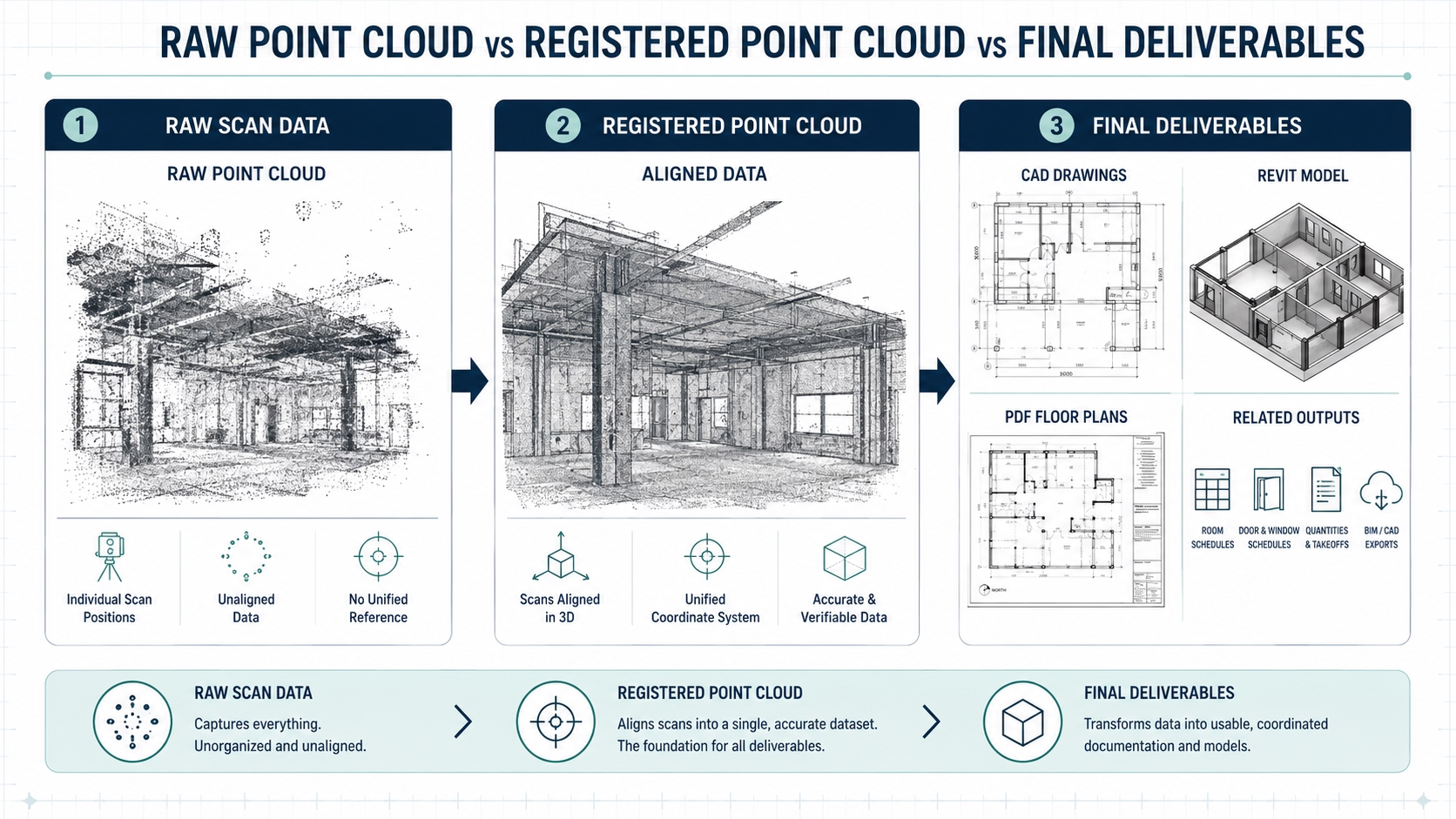
A raw point cloud is the unprocessed or minimally processed scan data captured during fieldwork. Raw scans may exist as separate scan positions and may not yet be aligned into a clean building dataset. Raw data is useful for the scanning provider, but it is not usually the most practical deliverable for architects, contractors, or owners. Clients should not assume raw scan data is ready for design work.
A registered point cloud is the aligned and coordinated version of the scan data. Registration connects scan positions into a single spatial dataset so the building can be reviewed consistently. This step is important because poor registration can affect the accuracy of drawings or models created from the point cloud. A professional point cloud services provider should check the registration before drafting or modelling begins.
Final deliverables are the files created from the point cloud for practical use. These may include floor plans, point cloud to CAD drawings, point cloud to Revit models, elevations, sections, BIM models, or area documentation. Final deliverables require interpretation because technicians must decide how to represent walls, openings, levels, irregular surfaces, and visible building elements. The practical rule is to order the deliverable that supports the next decision, not just the largest data file.
| Output type | What it is | Who uses it | Practical value |
|---|---|---|---|
| Raw scan data | Field capture data before full processing | Scanning provider | Internal processing reference |
| Registered point cloud | Aligned scan dataset | BIM teams, CAD teams, architects, engineers | Measured existing-condition reference |
| PDF floor plans | Readable 2D drawings | Owners, contractors, managers, tenants | Easy review and communication |
| DWG CAD drawings | Editable CAD files from the point cloud | Architects, designers, contractors | Design and renovation workflow |
| Revit model | BIM model created from scan data | Architects, BIM teams, engineers | Model-based coordination |
| IFC model | Open BIM exchange file | Multi-platform consultant teams | Cross-software collaboration |
| Elevations and sections | Vertical documentation from scan data | Architects, engineers, permit teams | Existing-condition coordination |
How Point Cloud to CAD Works
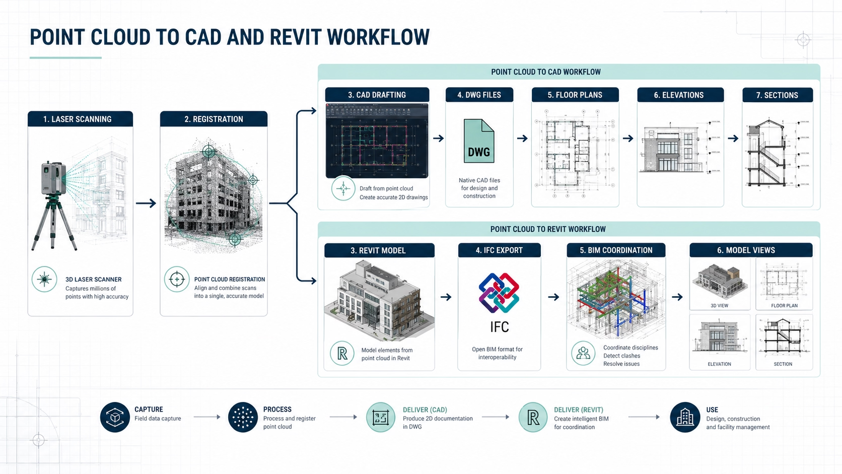
Point cloud to CAD converts scan data into editable CAD drawings. A drafting team uses the registered point cloud as a measured reference and creates 2D or 3D CAD linework that represents the agreed existing conditions. These drawings may include floor plans, elevations, sections, roof plans, reflected ceiling plans, or other views depending on the project scope. The practical value is that CAD files can be used directly by many architects, designers, and contractors.
Point cloud to CAD is useful when the project needs accurate 2D documentation but not a full BIM model. Many Vancouver renovations, tenant improvements, commercial layouts, and permit-support workflows can work effectively with DWG files and PDF drawings. CAD deliverables can show walls, openings, stairs, levels, columns, and other visible conditions in a format familiar to design teams. Clients should choose point cloud to CAD when editable 2D drawings are the main need.
Point cloud to CAD requires clear drafting scope. A basic floor plan may not include ceiling information, elevations, wall thickness details, roof geometry, or building systems unless these elements are requested. If the architect expects sections or exterior elevations, these should be included before pricing begins. The practical takeaway is to define which CAD drawings are required before the point cloud is converted.
How Point Cloud to Revit Works
Point cloud to Revit converts scanned existing conditions into a BIM model. BIM technicians use the registered point cloud as a reference and create Revit elements such as walls, floors, roofs, columns, beams, windows, doors, stairs, levels, and visible systems depending on scope. The Revit model can then support architectural design, consultant coordination, renovations, and digital building documentation. The practical rule is to choose point cloud to Revit when the project team will actively work in a BIM environment.
Point cloud to Revit is not automatic. The scanner captures measured points, but the BIM model must still be created by skilled modellers who interpret geometry and define model elements. Existing buildings are often irregular, so the modeller must decide how to represent non-square walls, sloped floors, uneven ceilings, or complex rooflines. These decisions should be guided by project needs. Clients should ask how the provider handles irregular geometry and modelling tolerance.
Point cloud to Revit is most valuable when three-dimensional coordination matters. A Revit model can help architects and consultants understand vertical relationships, levels, structural elements, openings, and visible systems more clearly than flat drawings alone. It can also help owners create a reusable digital building record. The practical takeaway is to request Revit deliverables when BIM adds coordination value, not just because a 3D model looks impressive.
How Point Clouds Become Floor Plans
Point clouds become floor plans when drafters extract the relevant horizontal building information from the scan data. The drafting team references the point cloud to trace walls, doors, windows, stairs, columns, openings, and fixed features into a clean plan view. The result may be delivered as a PDF, DWG, or part of a BIM model. For clients, the floor plan is often the most readable output from the point cloud.
Floor plans from point clouds are useful because they show existing conditions in a practical format. Owners can use them for planning and communication, architects can use them as a base for design, contractors can use them for pricing, and property managers can use them for records. A point cloud may contain more data than most stakeholders need, while a floor plan translates that data into a clear drawing. The practical takeaway is that floor plans make point cloud data easier to use.
Floor plans from point clouds should be scoped by purpose. A real estate-style floor plan may show room names and general dimensions, while renovation-grade floor plans may need more precise wall relationships, openings, stairs, structural elements, or file formats. A facility plan may need area zones, tenant boundaries, or service rooms. Clients should explain how the floor plans will be used before the drafting team starts.
Common 3D Scanning Deliverables
3D scanning deliverables vary by project type, budget, and end user. A simple deliverable package may include only PDF floor plans. A technical package may include registered point clouds, DWG files, elevations, sections, and Revit models. A facility documentation package may include digital records for long-term management. The practical recommendation is to choose deliverables based on the people who will use them.
| Deliverable | Description | Best use case | Key question to ask |
|---|---|---|---|
| Registered point cloud | Aligned scan data | Technical reference and future modelling | Is the point cloud included in the package? |
| PDF floor plans | Readable 2D plans | Owner review, contractor discussion, planning | Are dimensions and room labels included? |
| DWG floor plans | Editable CAD plans | Design and renovation workflows | Are layers and scale organized for architects? |
| Interior elevations | Vertical wall documentation | Millwork, interiors, heritage details | Which walls or rooms are included? |
| Exterior elevations | Façade documentation | Additions, heritage work, exterior design | Are rooflines and openings included? |
| Building sections | Vertical cuts through the building | Stairs, levels, ceiling heights, structure | How many sections are included? |
| Reflected ceiling plans | Ceiling layout documentation | Lighting, ceilings, mechanical coordination | Are ceiling elements visible and within scope? |
| Revit model | BIM model from point cloud | Model-based design and coordination | What elements and level of detail are modelled? |
| IFC export | Open BIM exchange file | Multi-platform consultant work | Is IFC required by the design team? |
| Area plans | Measured space or zone documentation | Leasing and property management | What measurement method or standard is used? |
A good 3D scanning deliverable package should include scope notes. These notes should explain which areas were scanned, which areas were inaccessible, which elements were drawn or modelled, and which hidden conditions were not verified. Without these notes, future users may assume the files contain more information than they actually do. Clients should ask for assumptions and limitations with the final deliverables.
Deliverables should also match software needs. An architect may need DWG or Revit files, a contractor may need PDFs and dimensions, and an owner may need easy-to-read plans. If the wrong file format is delivered, the project team may need conversion or redrafting. The practical takeaway is to confirm file formats with the end users before ordering point cloud services.
When a Point Cloud Alone Is Enough
A point cloud alone may be enough when the project team has the software and expertise to use it directly. Some architects, BIM teams, survey professionals, and engineers can import point cloud data into their own workflows and create their own drawings or models. In that case, the client may only need clean registered scan data. The practical rule is to order point cloud-only delivery only when someone on the project team can work with it.
A point cloud alone can be useful as a long-term digital site record. If a building owner wants to preserve a detailed record of existing conditions for future projects, the point cloud can be archived and reused later. This can be valuable for facilities, industrial spaces, heritage buildings, and large commercial properties. Owners should still understand that a point cloud is technical data, not a finished drawing set.
A point cloud alone is usually not enough for clients who need readable documentation. Homeowners, property managers, contractors, or tenants may not have the software or experience to interpret point cloud files. These clients usually need floor plans, CAD drawings, PDFs, or models created from the point cloud. The practical takeaway is to avoid point cloud-only delivery unless the end user is technical.
When You Need CAD, Revit, or Floor Plans Instead of Only Point Cloud Data
CAD drawings are usually needed when the project requires design, renovation planning, or contractor coordination in a 2D workflow. DWG files can be edited by architects and designers, shared with contractors, and used as a base for proposed layouts. For many Vancouver renovation projects, point cloud to CAD provides a practical balance between accuracy and usability. Clients should request CAD when the design team needs editable drawings.
Revit models are usually needed when the project requires BIM documentation, model-based design, consultant coordination, or long-term digital building records. Point cloud to Revit is useful for complex existing buildings, multi-level projects, commercial spaces, industrial facilities, and renovations where 3D coordination matters. Revit can also support consistent plans, sections, and elevations generated from the same model. Clients should request Revit when the model will be actively used.
Floor plans are usually needed when the client wants a clear, readable view of the building layout. Floor plans can support early planning, contractor estimates, leasing discussions, renovation concepts, and owner communication. A floor plan may be delivered as PDF, DWG, or part of a BIM package. The practical takeaway is that most clients need at least one readable drawing output in addition to the point cloud.
How Point Cloud Services Support Renovation Planning in Vancouver
Point cloud services support renovation planning by documenting the existing building before design work begins. Many Vancouver properties have older drawings, previous renovations, undocumented changes, or complex geometry that can affect proposed work. A point cloud can help the project team verify current conditions before preparing new layouts, elevations, or models. The practical benefit is fewer design assumptions at the start of the project.
Point cloud services support commercial tenant improvements by documenting the current lease space. Tenant spaces may include demising walls, office build-outs, washrooms, service areas, ceiling conditions, loading access, or previous alterations. Accurate documentation helps landlords, tenants, designers, and contractors align on what exists before improvement work begins. Property teams should use point cloud-derived documentation when tenant improvements depend on existing layout or services.
Point cloud services support heritage and older building projects by recording irregular or detailed visible conditions. Older buildings may have non-square rooms, sloped floors, decorative façades, unusual stair geometry, or previous structural changes. Manual measuring can miss these conditions, especially when documentation must support design or conservation decisions. The practical takeaway is to use point cloud services when the building’s existing geometry is part of the project risk.
How Point Cloud Services Affect Contractor Estimates and Change Orders
Point cloud services can improve contractor estimates by giving contractors more reliable existing-condition documentation. Contractors may use floor plans, CAD files, elevations, sections, or BIM models to understand quantities, access, demolition scope, and spatial constraints. If the documentation is incomplete, contractors may price from assumptions or add contingencies. Owners should provide the same point cloud-derived drawings to all bidders when comparing contractor estimates.
Point cloud services can reduce some change order risk by identifying visible spatial conflicts earlier. If proposed work is based on inaccurate existing drawings, conflicts may appear after demolition, fabrication, or installation begins. Point cloud to CAD or point cloud to Revit deliverables help the design team review existing conditions before construction starts. The practical takeaway is that better documentation can move some problem-solving into pre-construction.
Point cloud services do not eliminate every change order. Hidden conditions, concealed services, structural discoveries, hazardous materials, design changes, and owner scope changes can still affect cost. The point cloud records visible conditions, not everything inside walls or below slabs. A responsible project team should use point cloud documentation as one part of risk control, not as a guarantee of zero rework.
How Point Cloud Services Support Permit and Design Coordination
Point cloud services can support permit and design coordination by creating accurate existing-condition documentation. Renovations, additions, tenant improvements, and building upgrades often require drawings that distinguish existing conditions from proposed changes. Floor plans, elevations, sections, and Revit models created from point cloud data can help the design team communicate the existing building more clearly. Point cloud services do not guarantee permit approval, but they can support better documentation.
Vancouver and BC permit requirements depend on the municipality, property type, occupancy, zoning, building code requirements, and project scope. A point cloud services provider does not replace an architect, engineer, code consultant, or municipal reviewer. However, accurate existing-condition documentation can give those professionals a stronger base for their work. Clients should treat point cloud services as documentation support, not as legal or permit advice.
Point cloud services can also help consultants coordinate around the same existing-condition reference. Architects, structural engineers, mechanical consultants, interior designers, and contractors may all need to understand the same building. A shared point cloud, CAD base, or Revit model can reduce inconsistent assumptions between disciplines. The practical recommendation is to define consultant needs before scanning so the deliverables support the full project team.
Common Mistakes When Ordering Point Cloud Services
A common mistake is ordering a point cloud without knowing who will use it. A point cloud may be valuable for a BIM team, but it may not help a homeowner or contractor who needs readable drawings. If no one on the project team can open or interpret the point cloud, the client may still need CAD or PDF deliverables. Buyers should confirm the end user before choosing point cloud-only delivery.
Another common mistake is assuming all point cloud formats are interchangeable. Different software platforms may prefer E57, RCP, RCS, LAS, LAZ, or other formats. If the wrong format is delivered, the project team may need conversion or may lose time. Clients should ask the architect, engineer, or BIM team what format is required before final delivery.
A third mistake is asking for too much modelling detail without a clear use case. Detailed point cloud to Revit modelling can be valuable, but it takes time and budget. If the project only needs floor plans or CAD drawings, full BIM modelling may be unnecessary. The practical rule is to model only the elements that support real project decisions.
A fourth mistake is ignoring site access before scanning. Point cloud quality depends on what the scanner can see. Locked rooms, cluttered spaces, blocked façades, parked vehicles, and inaccessible ceilings can create gaps. Clients should prepare the site before scanning and ask how inaccessible areas will be documented in the final deliverables.
Practical Decision Matrix: What Should You Order After a 3D Laser Scan?
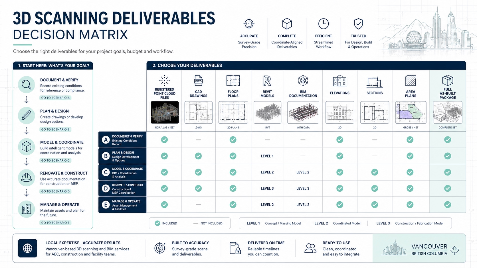
A practical decision matrix helps clients choose the right deliverable after a 3D laser scan. The best output depends on the project’s next step, the people using the files, and the complexity of the building. A technical team may want the point cloud, while a contractor may need drawings, and an architect may need CAD or Revit. The practical rule is to choose deliverables based on workflow, not file size.
| Project need | Best deliverable | Why it fits |
|---|---|---|
| Technical reference only | Registered point cloud | Gives the project team measured scan data |
| Home renovation planning | PDF floor plans and DWG files | Supports designers and contractors |
| Commercial tenant improvement | CAD floor plans, elevations, and sections | Helps coordinate existing and proposed work |
| Revit-based design | Point cloud to Revit model | Supports BIM workflow |
| Heritage façade documentation | Point cloud, elevations, and detailed CAD | Captures visible irregular details |
| Industrial facility upgrade | Point cloud, CAD, and possibly BIM | Supports complex spatial coordination |
| Leasing or area review | Floor plans and area documentation | Helps owners and tenants understand space |
| Long-term building record | Point cloud plus CAD or BIM package | Preserves reusable digital documentation |
The decision matrix should be reviewed before the scan is scheduled. If the project team knows the required deliverables early, the scanning team can plan capture more effectively. If the deliverables are defined after scanning, some areas may not have been captured at the required level of detail. Clients should define the output before fieldwork begins.
What to Ask a Point Cloud Services Provider
The first question to ask a point cloud services provider is which deliverables are included. Some providers deliver only scan data, while others provide point cloud registration, CAD drawings, Revit models, PDF sheets, or area plans. A quote should clearly explain what the client will receive. Buyers should not compare prices without comparing deliverables.
The second question to ask is which point cloud format will be delivered. The design team may need E57, RCP, RCS, LAS, LAZ, or another format. If the point cloud will be used in Autodesk, Bentley, Revit, AutoCAD, CloudCompare, or other platforms, compatibility should be confirmed in advance. The practical takeaway is to ask the end users what format they need.
The third question to ask is how the point cloud is checked. Registration quality, scan coverage, noise cleanup, and modelling verification all affect downstream documentation. A provider should be able to explain how the point cloud is reviewed before drawings or models are created. Clients should ask about quality control, not only scan speed.
The fourth question to ask is what limitations apply. Point cloud data is based on visible conditions, so hidden structure, concealed pipes, and inaccessible areas may not be captured. The provider should explain how these limitations are documented. Buyers should prefer clear limitation notes over unrealistic promises.
How to Prepare for a 3D Laser Scan
Clients should prepare for a 3D laser scan by making the required areas accessible. The scanning team may need access to rooms, corridors, stairwells, garages, mechanical spaces, roofs, exterior walls, loading areas, tenant spaces, or service areas depending on the project scope. Locked doors and blocked areas can create missing data. The practical recommendation is to coordinate access before the appointment.
Clients should reduce clutter where possible. The scanner captures visible surfaces, so stored boxes, furniture, vehicles, construction materials, or equipment can block walls, floors, and openings. Not every space must be empty, but major obstructions should be moved if they affect the areas being documented. Better visibility leads to more complete point cloud data.
Clients should also share project priorities with the scanning team. If the final deliverable needs accurate stairs, rooflines, exterior façades, ceiling heights, mechanical rooms, tenant boundaries, or structural columns, the team should know before scanning. Clear priorities help the scanning provider plan coverage. The practical takeaway is that good scan planning starts with knowing what the point cloud must support.
Key Takeaways
Point cloud services Vancouver help turn 3D laser scan data into useful building documentation. The point cloud is the measured digital reference, but clients often need processed outputs such as floor plans, CAD drawings, Revit models, elevations, sections, or BIM documentation. The main value comes from choosing deliverables that match the project workflow.
Point cloud to CAD is useful when the project needs editable 2D drawings for design, renovation, tenant improvements, or contractor coordination. Point cloud to Revit is useful when the project team needs BIM documentation, model-based design, consultant coordination, or long-term digital building records. Floor plans are useful when the client needs a readable summary of existing layout.
The best time to define point cloud deliverables is before the 3D laser scan. If the project team knows what files are needed, the scanning provider can plan site capture and processing more effectively. The practical next step is to ask the architect, contractor, or owner team what output they need, then order the point cloud services package that supports that decision.
FAQ
What are point cloud services Vancouver?
Point cloud services Vancouver convert 3D laser scan data into useful existing-condition documentation. A provider may deliver registered point cloud files, floor plans, CAD drawings, Revit models, elevations, sections, or BIM documentation. The point cloud is the measured spatial dataset, while the final deliverables turn that dataset into files that architects, contractors, owners, and facility managers can actually use.
What is a point cloud after a 3D laser scan?
A point cloud is a digital collection of measured points captured by a 3D laser scanner. These points represent visible building surfaces such as walls, floors, ceilings, columns, stairs, openings, and other elements. The point cloud is used as a reference for creating floor plans, CAD drawings, Revit models, elevations, sections, and as-built documentation.
What files do I get after laser scanning Vancouver projects?
After laser scanning Vancouver projects, clients may receive registered point cloud files, PDF floor plans, DWG CAD drawings, Revit models, IFC files, elevations, sections, reflected ceiling plans, or area documentation. The exact files depend on the project scope. Before scanning begins, clients should confirm which formats are included and whether the design team can use them.
What is point cloud to CAD?
Point cloud to CAD is the process of converting scanned point cloud data into editable CAD drawings. Drafters use the point cloud as a measured reference to create floor plans, elevations, sections, and other drawings. Point cloud to CAD is useful for renovations, tenant improvements, contractor pricing, and design workflows where architects or designers need DWG files.
What is point cloud to Revit?
Point cloud to Revit is the process of creating a BIM model from laser scan data. BIM technicians use the registered point cloud as a reference and model building elements such as walls, floors, roofs, columns, doors, windows, stairs, and visible systems depending on scope. Point cloud to Revit is useful when the project team works in BIM or needs model-based coordination.
Is a point cloud the same as a BIM model?
A point cloud is not the same as a BIM model. A point cloud is measured scan data made of millions of points. A BIM model is an interpreted digital building model created from the point cloud or other sources. The point cloud records visible geometry, while the BIM model organizes that geometry into building elements that can support design and coordination.
Do I need a point cloud or floor plans?
You need a point cloud if your technical team can use scan data directly or wants a long-term measured record. You need floor plans if you want readable documentation for renovation planning, contractor discussion, leasing, or owner review. Many projects benefit from both: the point cloud as the measured reference and floor plans as the practical communication tool.
Can point cloud services reduce change orders?
Point cloud services can reduce some change order risk by improving existing-condition documentation before construction starts. CAD drawings or Revit models created from scan data can help identify visible spatial conflicts earlier. Point clouds do not reveal hidden conditions or guarantee zero change orders, but they can reduce avoidable issues caused by inaccurate or outdated measurements.
Can point cloud services support permit drawings?
Point cloud services can support permit drawings by helping architects and consultants create more accurate existing-condition plans, elevations, sections, and models. These files can help distinguish existing conditions from proposed work. Point cloud documentation does not guarantee permit approval because approval depends on design, code, zoning, municipal review, and professional responsibility.
What should I ask before ordering point cloud services?
Before ordering point cloud services, ask what deliverables are included, which point cloud format will be provided, whether CAD or Revit modelling is included, what areas will be scanned, and how inaccessible areas are handled. Also ask how registration and quality control are checked. These questions help ensure the final files match the needs of your architect, contractor, or owner team.
Conclusion
Point cloud services in Vancouver help project teams turn 3D laser scan data into practical building documentation. The point cloud is the measured digital record, but the most useful deliverable may be a CAD drawing, Revit model, floor plan, elevation, section, or BIM package created from that data. For renovations, tenant improvements, facilities, older buildings, and complex properties, point cloud services can reduce reliance on outdated drawings and give architects, contractors, and owners a stronger existing-condition base. The best next step is to define who will use the files, what format they need, and whether the project requires point cloud-only data, point cloud to CAD, point cloud to Revit, or readable floor plans.

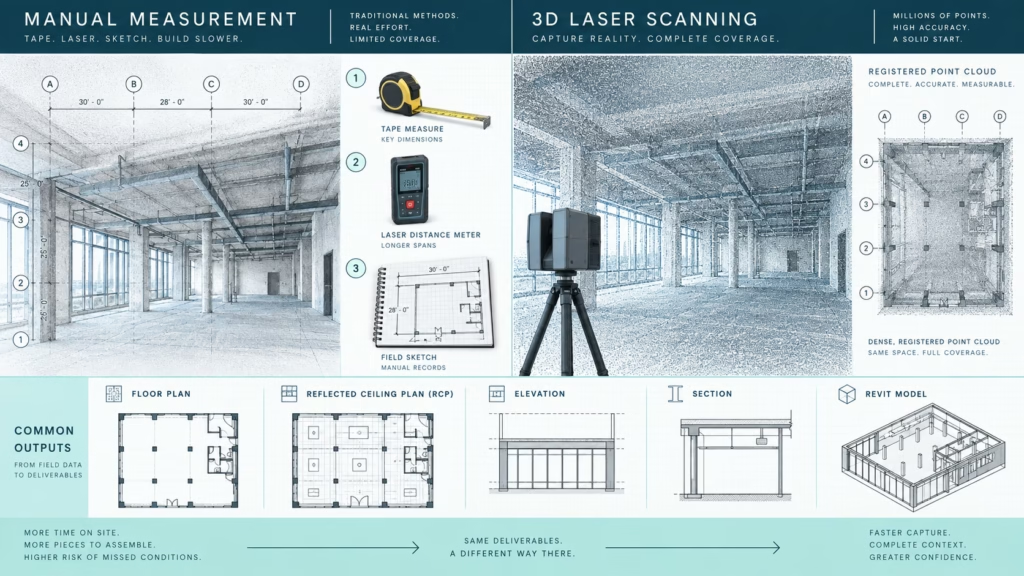
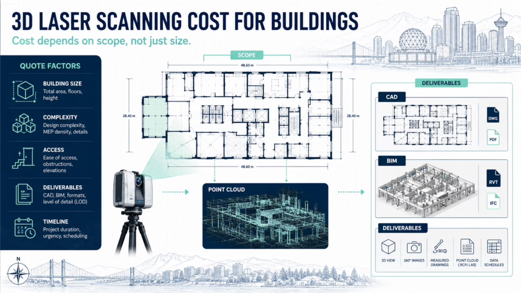
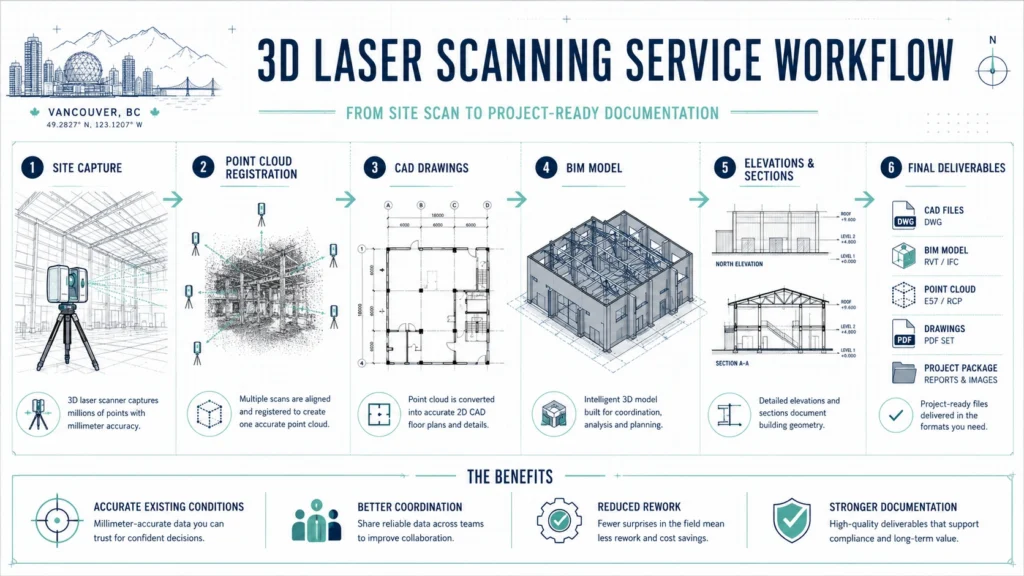
Analyse this page with AI
Want a summary, fact-check, or an RFP template built around these measurement standards? Send this page directly to your favourite AI model.
Content and prompt will be copied to clipboard for some models.