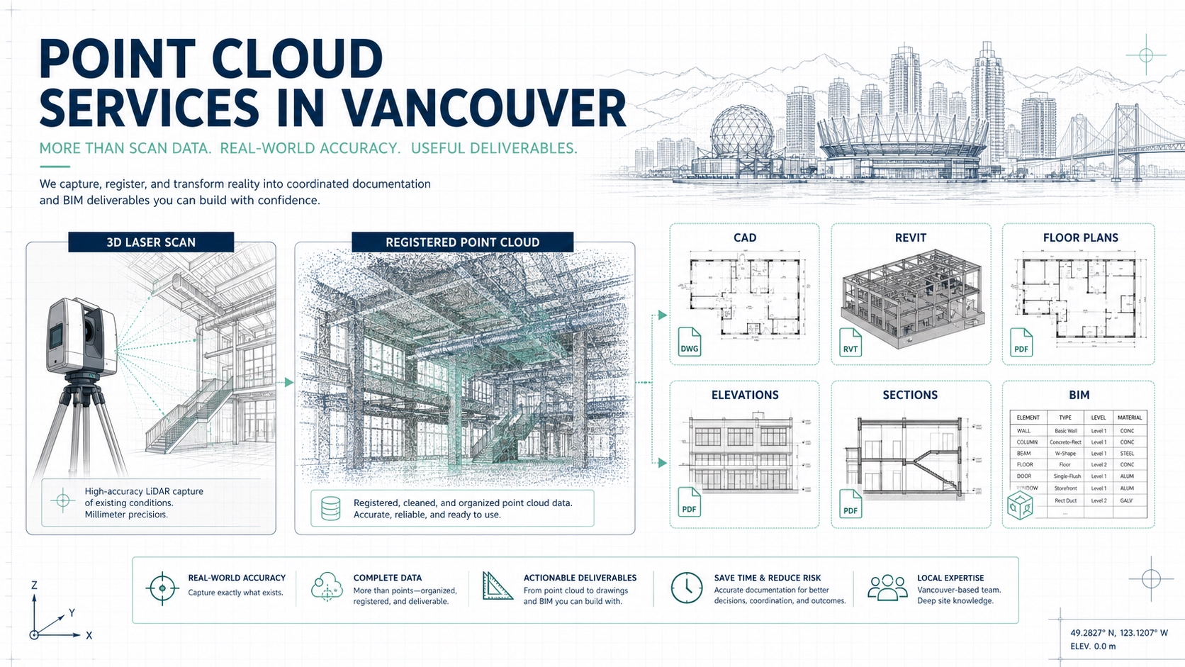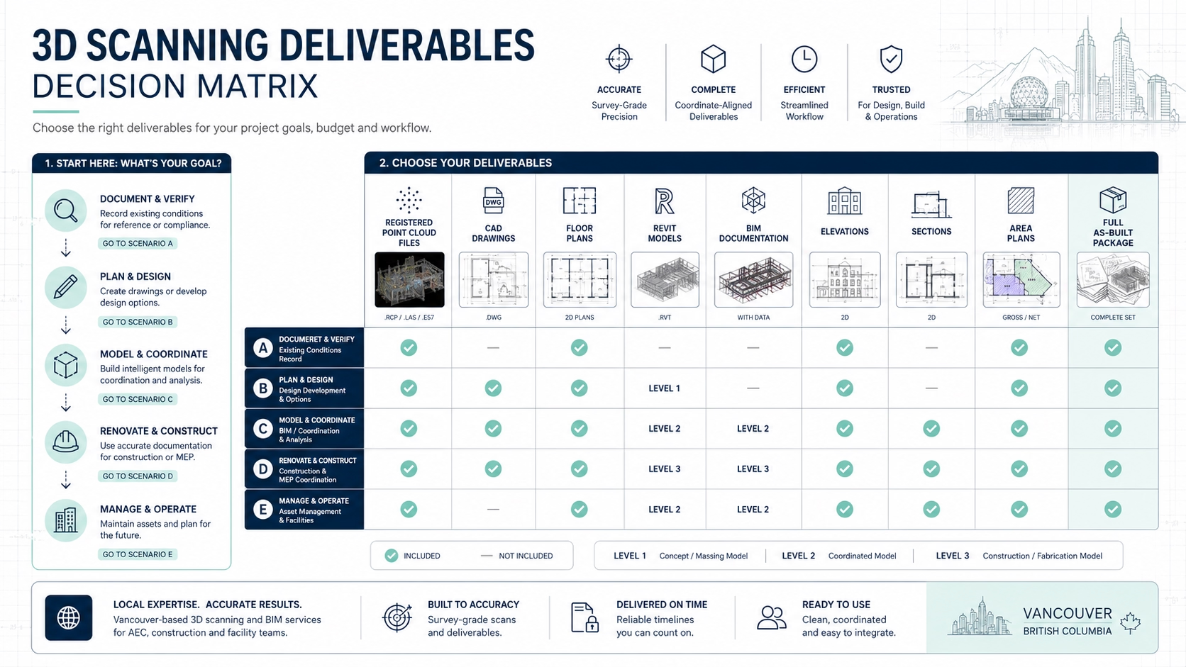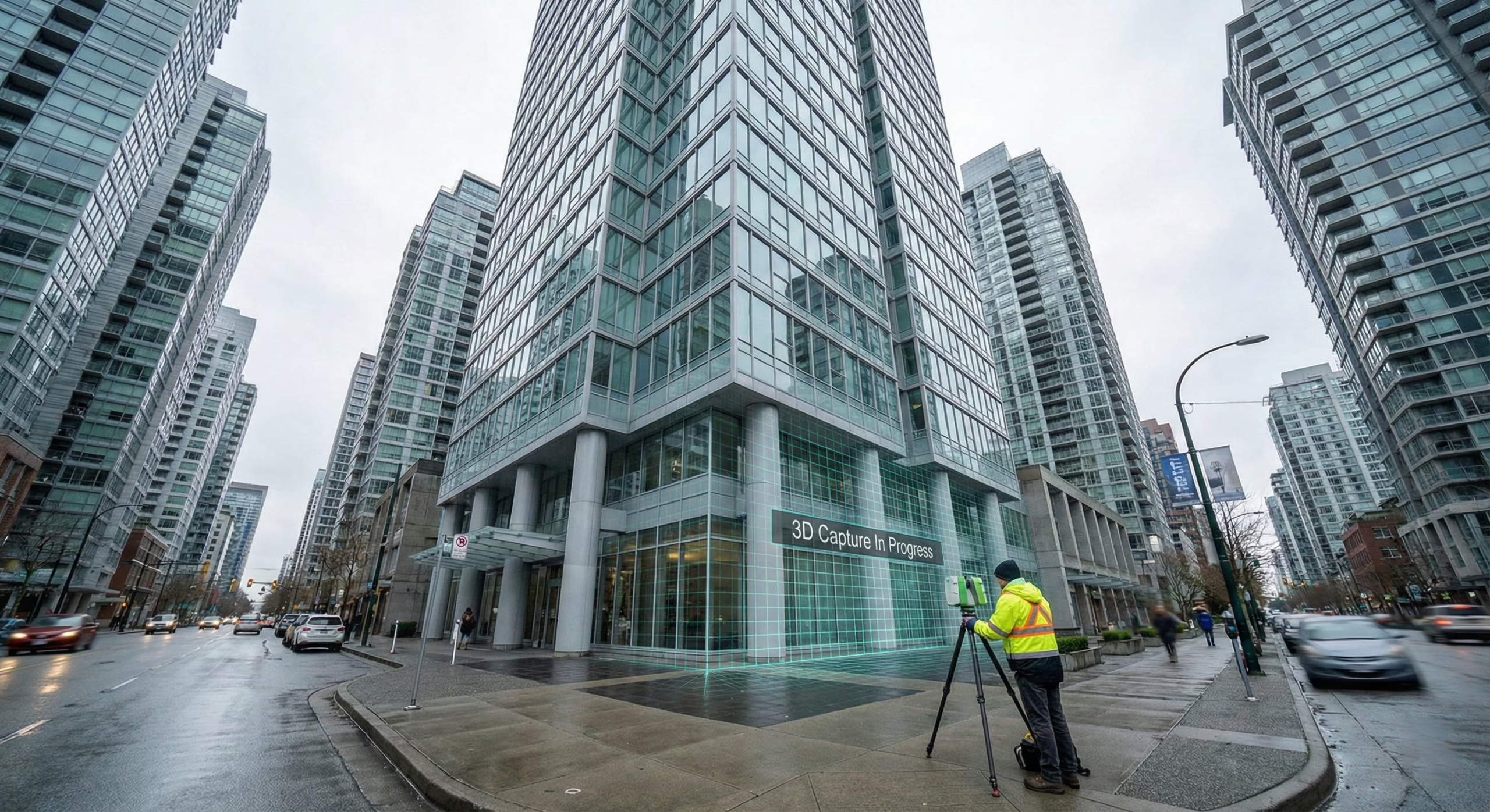
3D Scanning Trends Vancouver: As-Built Surveys & BIM

The architecture, engineering, and construction (AEC) industry in British Columbia is undergoing structural transformation. Rising construction costs, regulatory scrutiny, labor shortages, and compressed project timelines are forcing professionals to eliminate uncertainty wherever possible.

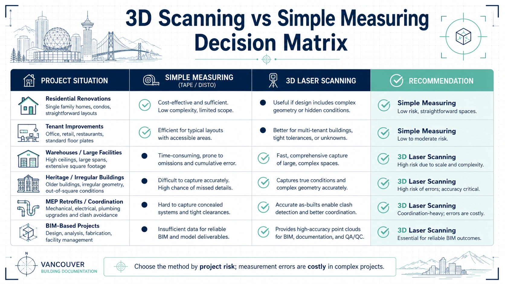
Traditional manual measurement methods – tape measures, distos, hand sketches – are no longer sufficient for high-value assets. In their place, reality capture technologies powered by LiDAR and integrated into Building Information Modeling (BIM) workflows are becoming the operational standard.

In Vancouver, this shift is particularly pronounced. From industrial leasing due diligence to complex home renovations in Greater Vancouver, precision is no longer optional – it is a risk management strategy.

The Current State of Construction Technology in Canada

Canada has historically adopted digital construction technologies more conservatively than parts of Europe and Asia. That gap is narrowing rapidly.

Key drivers include:

  • Skilled labor shortages
  • Increased litigation risk
  • Demanding municipal review processes
  • Tight financing and lender oversight
  • Higher expectations for cost certainty

The industry is transitioning from 2D documentation toward data-driven 3D intelligence. As-built surveys are evolving from static drawings into dynamic datasets.

From 2D Drafting to 3D Intelligence

Traditional surveys often miss critical realities:

  • Wall deviations
  • Slab deflection
  • Structural irregularities
  • MEP conflicts
  • Envelope distortion

Manual measurement introduces sampling risk. You measure what you can see and reach – but not necessarily everything that matters.

3D laser scanning eliminates sampling bias by capturing millions of spatial data points. The result is a high-density point cloud – a digital twin of the existing structure.

In dense urban environments like Vancouver, where heritage preservation, zoning constraints, and high land values intersect, precise geometry directly affects project viability.

Why 3D Laser Scanning Is Replacing Traditional Surveying

1. Precision at Scale

Modern terrestrial LiDAR scanners capture millimeter-level accuracy. Mobile SLAM-based systems can document up to 150,000 square feet per day.

Unlike legacy drawings – which reflect design intent – laser scanning documents existing reality.

That distinction is critical in:

  • Industrial acquisitions
  • Tenant improvements
  • Renovation planning
  • Envelope retrofits

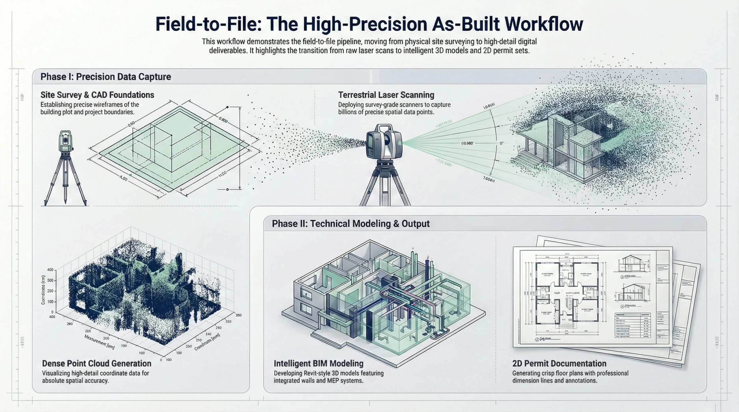
2. The "Field-to-File" Workflow

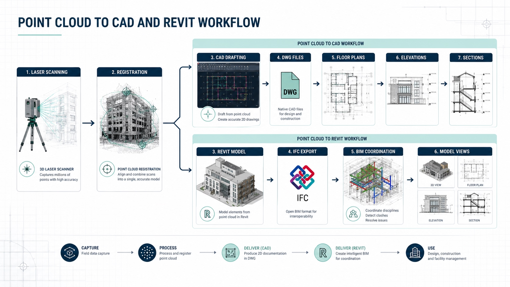
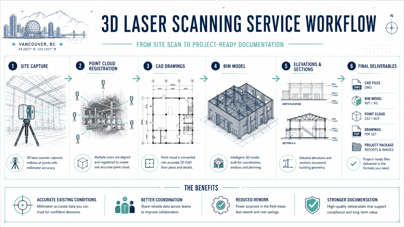
A growing 3D scanning trend in Vancouver is the field-to-file workflow:

  1. 1. Capture entire structure digitally
  2. 2. Register and clean point cloud
  3. 3. Model in CAD or BIM
  4. 4. Produce permit-ready documentation

No assumptions. No back-check site visits. Reduced change orders.

For renovation-heavy markets like Greater Vancouver, this workflow significantly reduces construction-phase surprises.

Scan-to-BIM workflow for 3D scanning trends in Vancouver construction projects

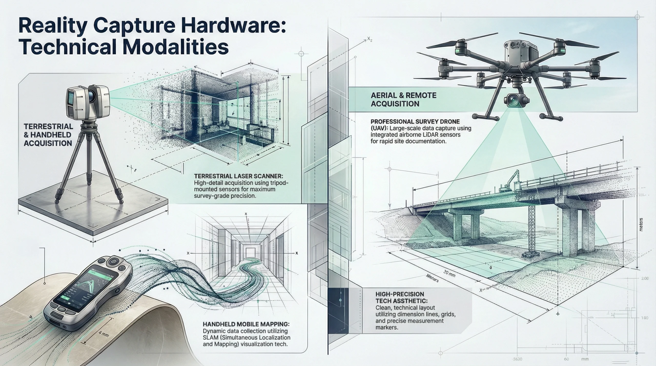
Visual comparison of LiDAR, mobile mapping, and SLAM technologies used in 3D scanning trends Vancouver construction projects

Key 3D Scanning Trends in Vancouver

Mobile Mapping and SLAM

While static terrestrial scanners remain the gold standard for high-accuracy deliverables, SLAM-based mobile systems are increasingly used for:

  • Large industrial facilities
  • Warehouses
  • Real estate marketing floor plans
  • Rapid due diligence scans

These systems prioritize speed and coverage while maintaining acceptable accuracy tolerances for leasing and planning purposes.

LiDAR and mobile mapping technology used for fast 3D scanning in Vancouver

Drone Integration for Exterior Capture

Unmanned Aerial Vehicles (UAVs) are now routinely integrated into building surveys.

Applications include:

  • Roof condition documentation
  • Façade inspection
  • Site context modeling
  • Hard-to-access envelope conditions

Combined with terrestrial scans, drones create a complete building dataset.

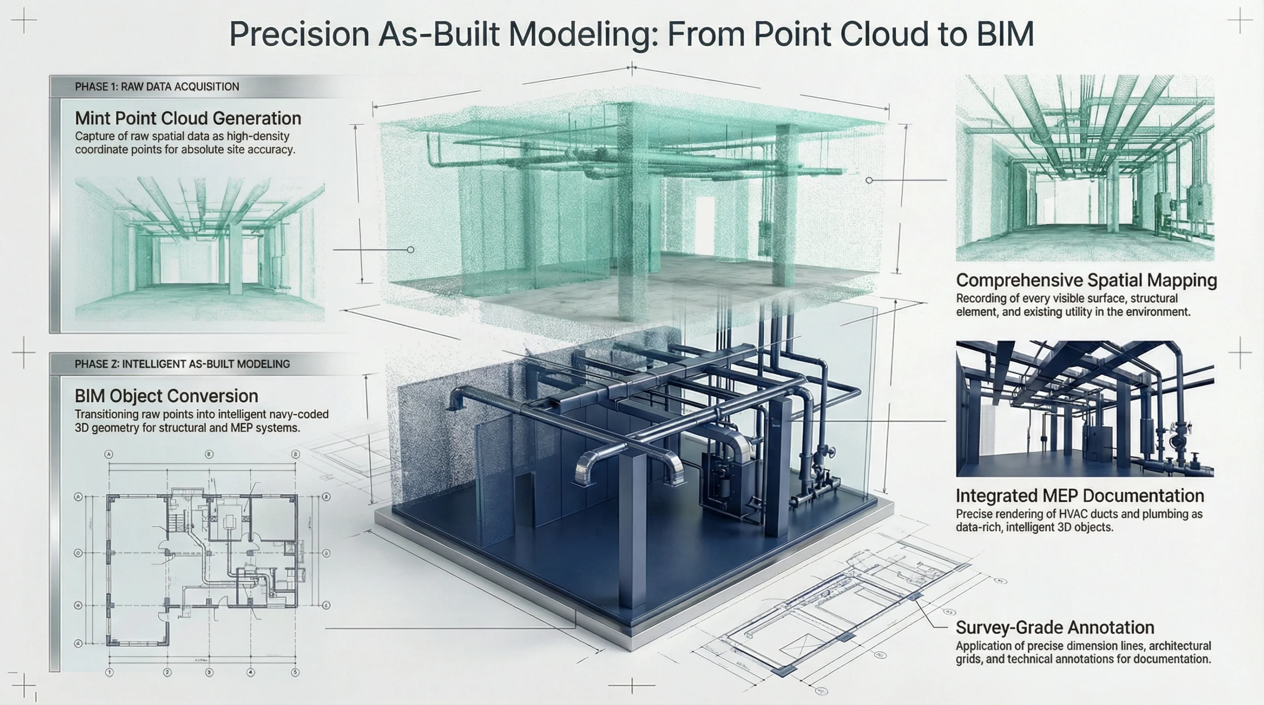
Scan-to-BIM Workflows

Scan-to-BIM is the most consequential development in reality capture.

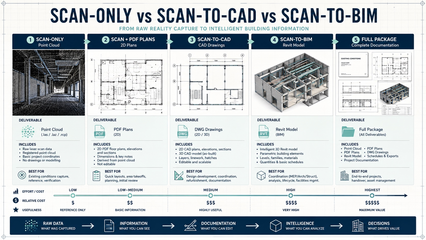
Instead of delivering only 2D CAD drawings, professionals now generate intelligent BIM models (typically in Revit), where:

  • Walls are parametric objects
  • Floors contain thickness data
  • Pipes carry diameter information
  • Openings are embedded within assemblies

Benefits include:

  • Clash detection before construction
  • Accurate quantity take-offs
  • Retrofit planning
  • Energy modeling
  • Facility management integration

This is driving the rise of BIM as-built standards across Canada.

BIM as-built model created from 3D scanning data in Vancouver

BIM As-Built in Canada: A New Renovation Standard

An as-built BIM model represents a structure at a specific moment in time, reflecting real-world conditions – not design assumptions.

For Home Renovation in Greater Vancouver

The region's aging housing stock often lacks reliable drawings. Renovation begins with uncertainty.

A 3D scan provides:

  • Verified structural geometry
  • Accurate floor areas
  • Envelope measurements
  • Non-invasive verification

This enables:

  • Off-site prefabrication
  • Millwork precision
  • Structural planning without demolition risk

In high-cost markets, eliminating unknowns protects both schedule and margin.

BOMA Standards and Commercial Measurement

In commercial real estate, square footage equals revenue.

3D laser scanning services are increasingly used to certify measurements in accordance with BOMA Industrial and BOMA Office standards.

Benefits include:

  • Accurate rentable area calculations
  • Lease dispute mitigation
  • Revenue optimization
  • Lender-grade documentation

In industrial acquisition due diligence, verified area data directly influences underwriting.

From Point Cloud to Permit Drawings

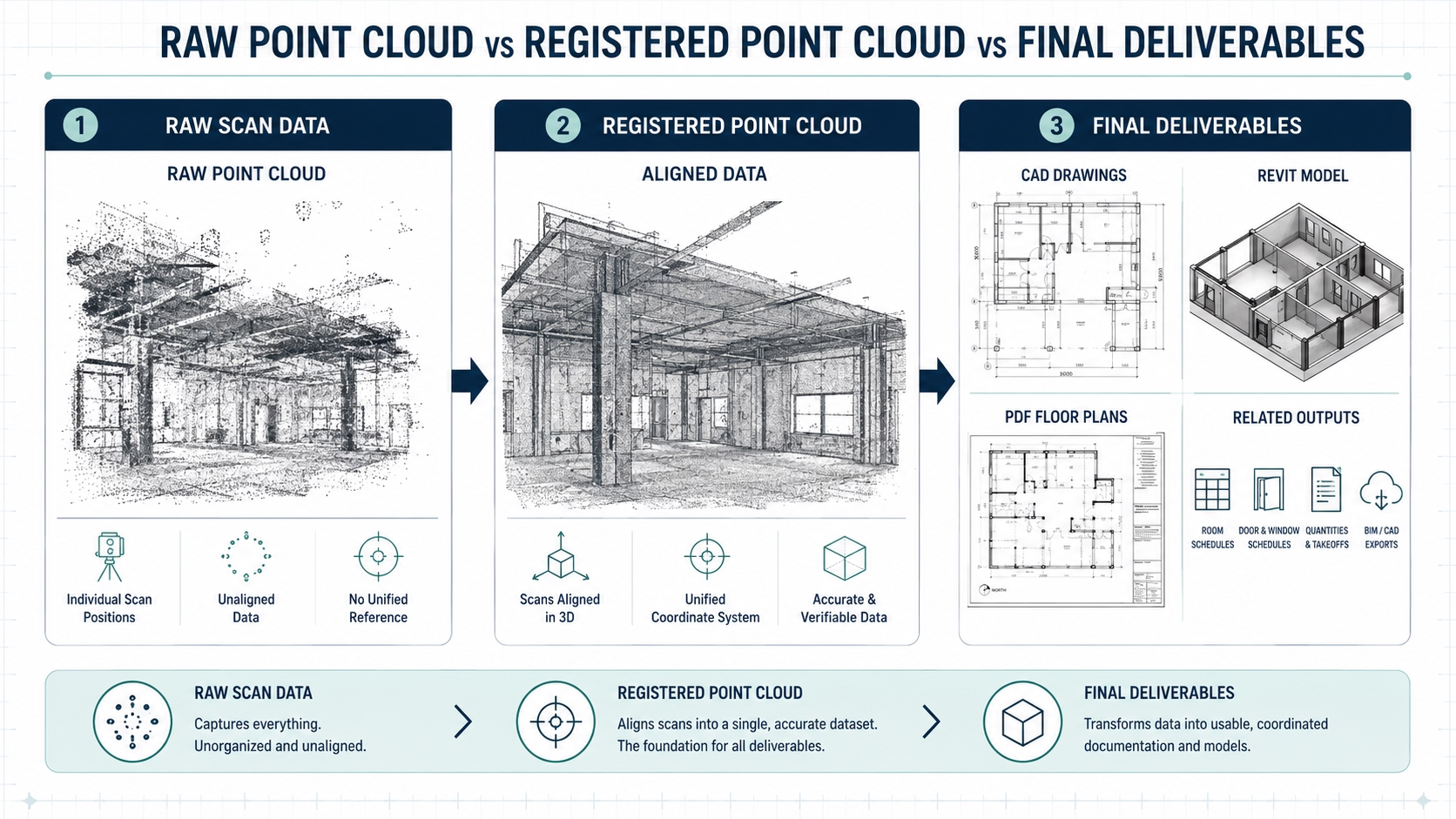
A scan is not the final deliverable. It is raw spatial data.

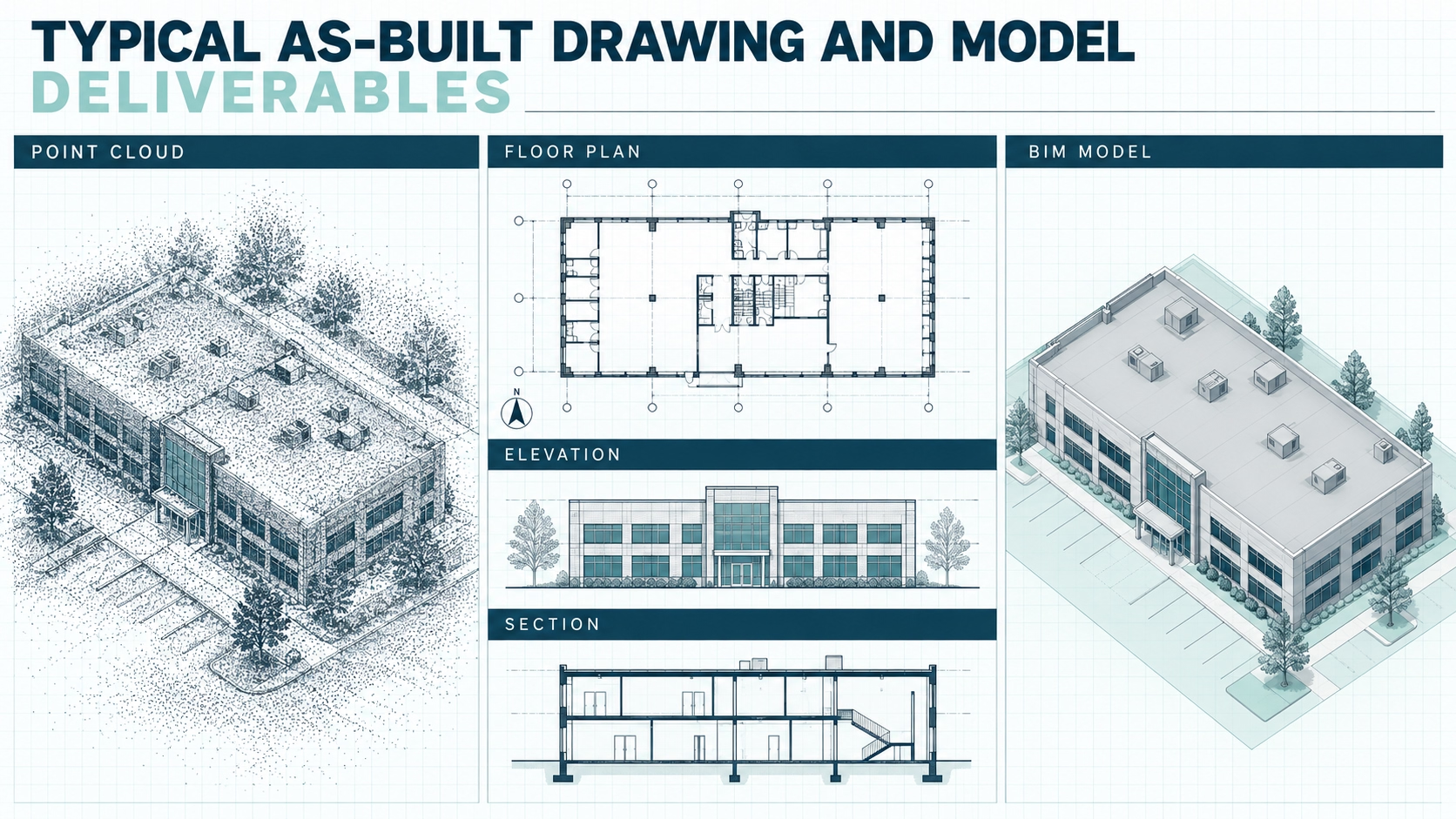
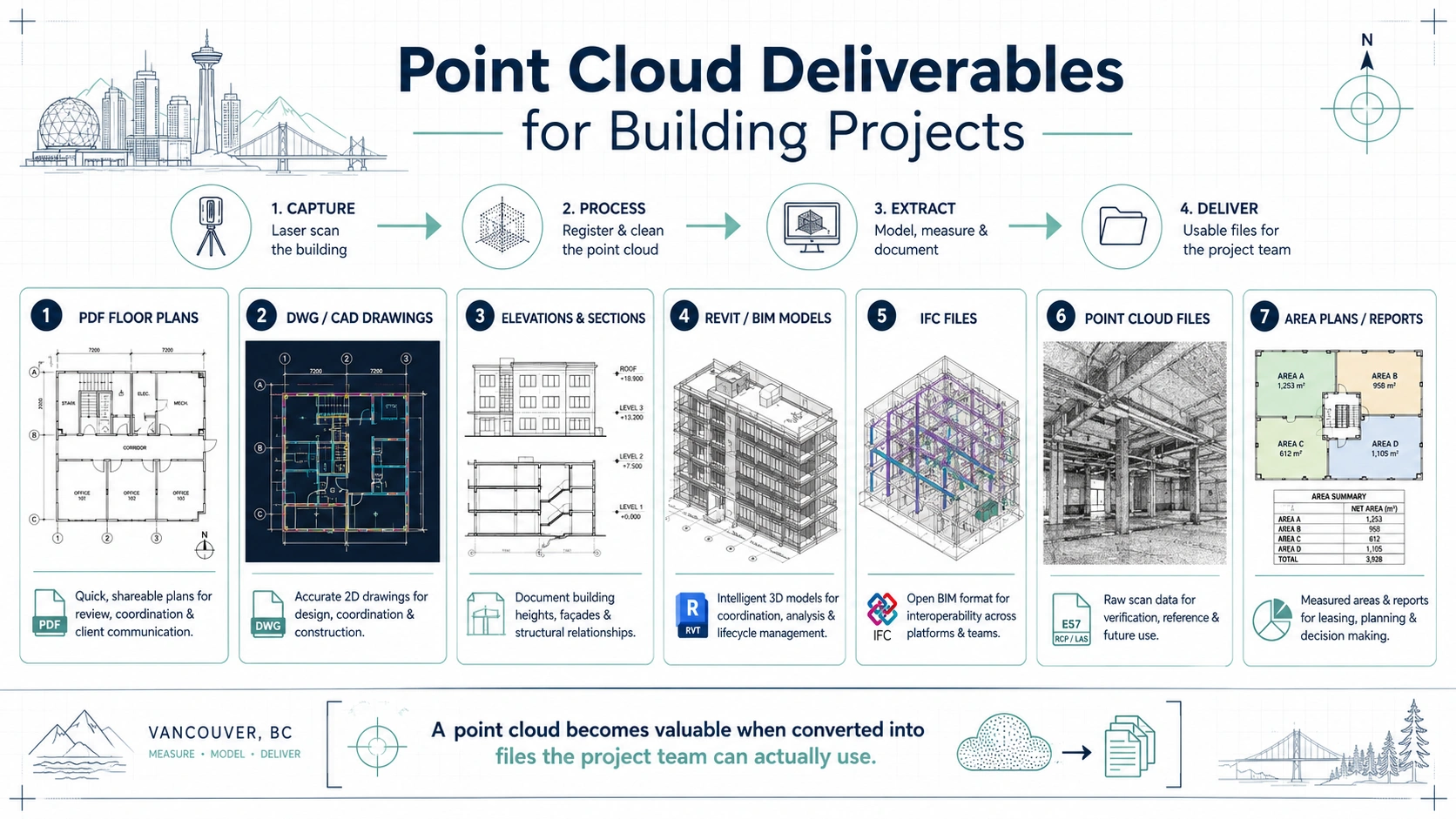
Professional interpretation converts point clouds into:

  • 2D as-built floor plans
  • Elevations and sections
  • Reflected ceiling plans
  • Fully modeled BIM environments

For Vancouver permit submissions, accuracy is critical. Plan reviewers require:

  • Correct egress widths
  • Window area compliance
  • Occupancy calculations
  • Clear height documentation

Reality capture ensures drawings reflect actual site conditions, not assumptions.

Business Case for Designers, Contractors, and Brokers

Interior Designers

For interior designers, the shell must be exact.

Scan-derived models allow:

  • Precise furniture layouts
  • Lighting coordination
  • Custom millwork fabrication
  • VR visualization

Irregular walls and legacy construction are no longer design constraints.

Contractors

Contractor estimates often include contingencies to cover unknown site conditions.

With 3D scanning:

  • Material take-offs are automated
  • Structural conflicts are visible early
  • Mechanical rerouting can be planned pre-demolition

The result: tighter bids and reduced change orders.

Real Estate Professionals

In Vancouver's competitive market, accurate floor plans protect liability exposure.

Laser-derived plans provide:

  • Verified square footage
  • Marketing-grade floor plans
  • Digital twin tours
  • Increased buyer trust

Accuracy is not just technical – it is reputational.

Technical Overview: The Scan-to-BIM Workflow

For industry professionals evaluating adoption:

1. Pre-Scan Planning

Determine scanner positions to minimize occlusion and maximize coverage.

2. Data Capture

LiDAR measures distance using time-of-flight laser pulses.

3. Registration

Individual scans are stitched into a unified coordinate system.

4. Processing & Cleaning

Noise reduction and alignment refinement.

5. Modeling

Import into Revit or CAD platforms for object-based modeling.

6. Quality Assurance

Cross-check measurements and tolerances.

The integrity of each stage determines final deliverable reliability.

The Future: AI and Digital Twins in Vancouver

The next evolution of 3D scanning trends in Vancouver includes:

AI-Assisted Modeling

Machine learning algorithms are beginning to auto-detect:

  • Walls
  • Doors
  • Windows
  • Structural members

This reduces modeling time and increases consistency.

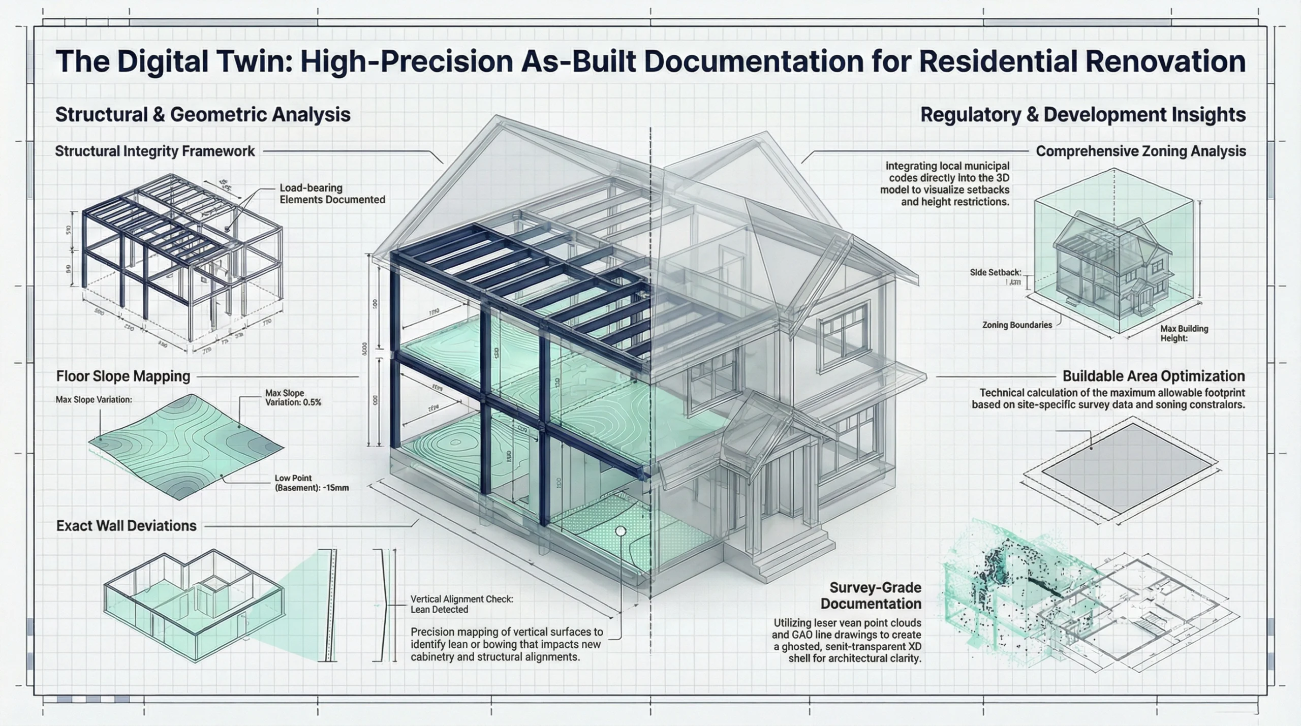
Persistent Digital Twins

Buildings are moving toward lifecycle-based digital records:

  • Updated after renovations
  • Integrated with facility management systems
  • Used for predictive maintenance

Reality capture is becoming a permanent asset – not a one-time survey.

Persistent digital twin supporting renovation and facility management in Vancouver

Conclusion: Precision as Competitive Advantage

Vancouver's construction and real estate markets are too capital-intensive to rely on approximation.

3D laser scanning and BIM-based as-built documentation represent a structural shift toward certainty.

Whether for:

  • Industrial leasing
  • Tenant improvements
  • Permit submissions
  • Renovation planning
  • Commercial underwriting

The future belongs to those who build from verified reality – not assumptions.

Precision is no longer a technical upgrade. It is a business strategy.

Ready to Future-Proof Your Projects?

Contact MeasureBuilt today to discover how our advanced 3D scanning and BIM services can position your Vancouver projects at the forefront of construction technology.

MeasureBuilt: Where Details Matter

3D Laser Scanning vs. Traditional Measuring in Vancouver

The construction and real estate landscape in British Columbia is undergoing a profound transformation, driven by the demand for absolute precision and the increasing complexity of modern architectural designs. For decades, the industry relied on tape measures, laser distance meters, and manual sketches to document existing conditions. However, as 3D laser scanning in Vancouver becomes the new benchmark for accuracy, professionals are realizing that traditional methods simply cannot compete with the data density and reliability of Light Detection and Ranging (LiDAR) technology.

Whether you are an architect retrofitting a heritage building in Gastown or a homeowner planning a major renovation in Kitsilano, understanding the shift from manual measurement to digital reality capture is essential for project success.

The paradigm shift: understanding 3D laser scanning in Vancouver

In the high-stakes environment of the Lower Mainland's property market, the margin for error is non-existent. 3D laser scanning in Vancouver represents a technological leap that replaces manual interpretation with hard data. Unlike a surveyor using a total station or a contractor with a tape measure – who captures single points one at a time – a 3D laser scanner captures millions of data points per second.

This creates a "point cloud," a dense digital replica of the physical space that maps every surface, edge, and geometric irregularity with millimeter-level precision.

The limitations of traditional surveying

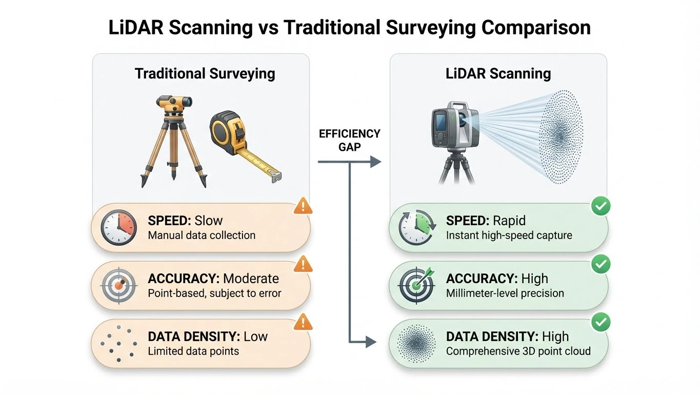
To appreciate the revolution, we must acknowledge the limitations of the past. Traditional surveying relies heavily on manual instruments and human recording. While tools like total stations are fundamental for land development, they are often labor-intensive and time-consuming when applied to complex building interiors.

The traditional workflow is fraught with potential pitfalls:

  • Human error: manual measurements are susceptible to reading errors, transcription mistakes, and the "human factor" of interpreting where a wall starts or ends.
  • Incomplete data: a tape measure only records what you decide to measure. If a beam is missed or a ceiling height is assumed to be uniform when it is actually sloped, the resulting construction documentation will be flawed.
  • Site accessibility: traditional methods require physical access to every point being measured, posing safety risks when measuring high ceilings or unstable structures.
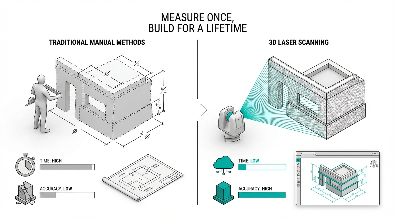
Comparison of 3D laser scanning and traditional manual measurement methods

Comparative analysis: accuracy, speed, and efficiency

For stakeholders in the AEC (Architecture, Engineering, and Construction) industry, the choice between 3D laser scanning in Vancouver and traditional methods often comes down to the "iron triangle" of project management: time, cost, and quality.

Unmatched accuracy and precision

Precision is paramount in surveying, and 3D laser scanning excels where manual methods falter. While a good manual survey might be accurate to within a few centimeters, 3D laser scanning services consistently deliver accuracy within millimeters. This is critical in Vancouver, where property lines are tight and density is high.

This level of precision is vital for generating accurate floor plans. In older Vancouver homes, walls are rarely perfectly square. A manual measurement might "idealize" these features, leading to design errors later. A laser scan reveals the truth, allowing architects to design around the actual conditions.

Speed of data collection

Time is a critical resource in the construction industry. 3D laser scanning services can reduce data collection time by up to 50% compared to traditional methods.

  • Rapid coverage: a laser scanner can record millions of points per second, covering complex areas in a fraction of the time required for manual measurement.
  • Reduced site visits: because the scanner captures everything in its line of sight, the need for return visits to measure a forgotten dimension is virtually eliminated.

Safety and accessibility benefits

In the challenging terrain of British Columbia, from steep slopes in West Vancouver to industrial sites in Burnaby, safety is a major concern. Laser scanning allows professionals to capture data remotely. An operator can scan a crumbling facade or a high-voltage electrical substation from a safe distance, significantly mitigating safety risks.

Transforming renovation planning and home renovation in Greater Vancouver

The retrofit and renovation market is a massive sector in British Columbia. Home renovation projects in Greater Vancouver are particularly sensitive to the quality of as-built drawings.

The "zero rework" strategy

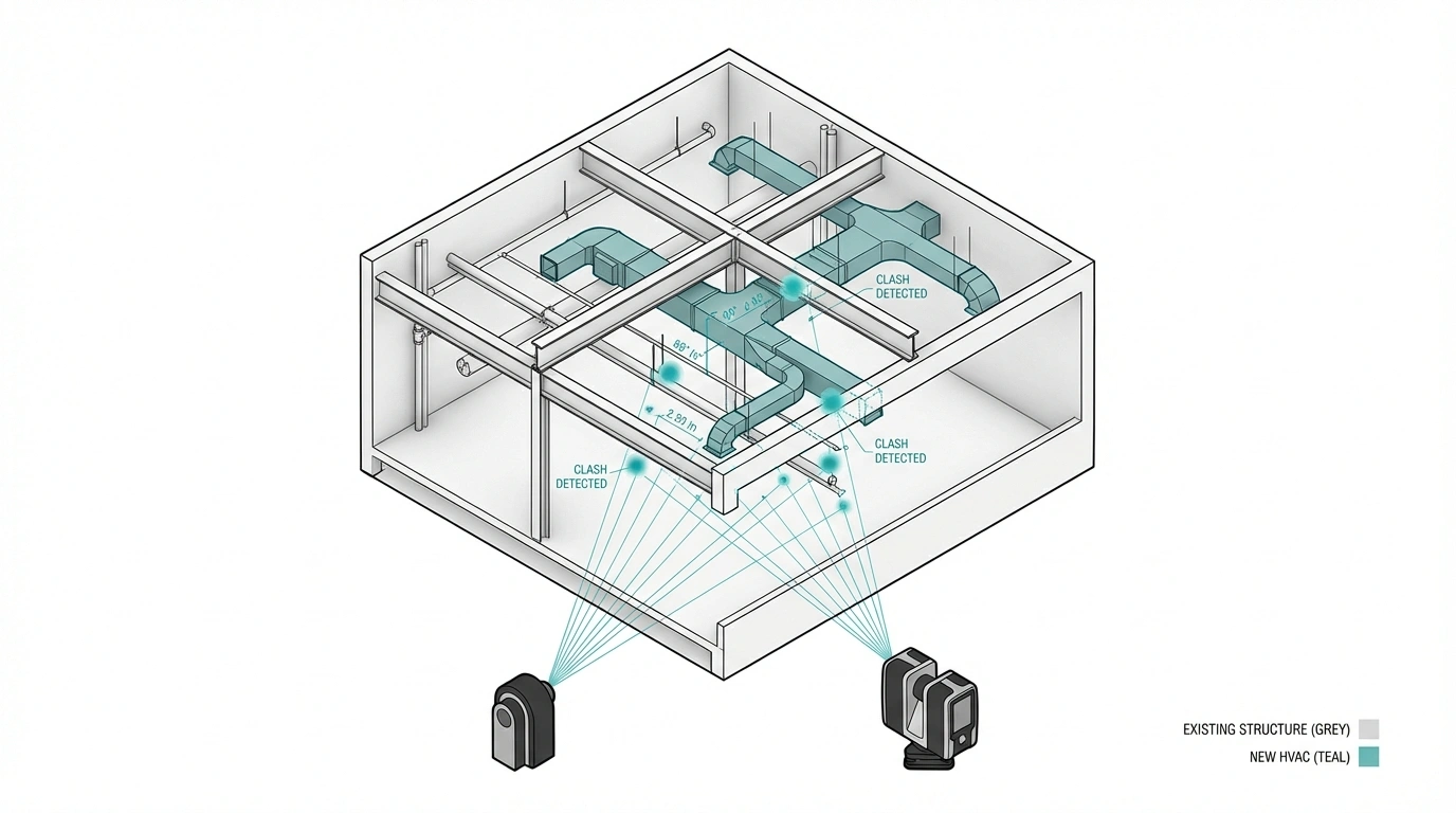
One of the most costly phrases in construction is "it doesn't fit." In traditional workflows, contractors often encounter surprises when new prefabricated components arrive on site and clash with existing mechanical systems. Using 3D laser scanning services enables a "zero rework" strategy. By verifying as-built conditions against design intent in a 3D model, contractors can perform clash detection – for example, verifying if a new HVAC run will hit an existing structural beam.

Interior renovation clash detection using 3D laser scanning data

Interior designer tools and visualization

For interior designers, the point cloud is a game-changer. It provides a foundation for creating crucial interior designer tools such as virtual walkthroughs and photorealistic renders.

  • Complex geometries: scanning captures irregular features like curved walls and custom millwork that are notoriously difficult to measure by hand.
  • Material estimation: the precision of the scan allows for exact calculation of material needs, reducing waste and ensuring more accurate contractor estimates.

From scan to BIM: the future of construction documentation

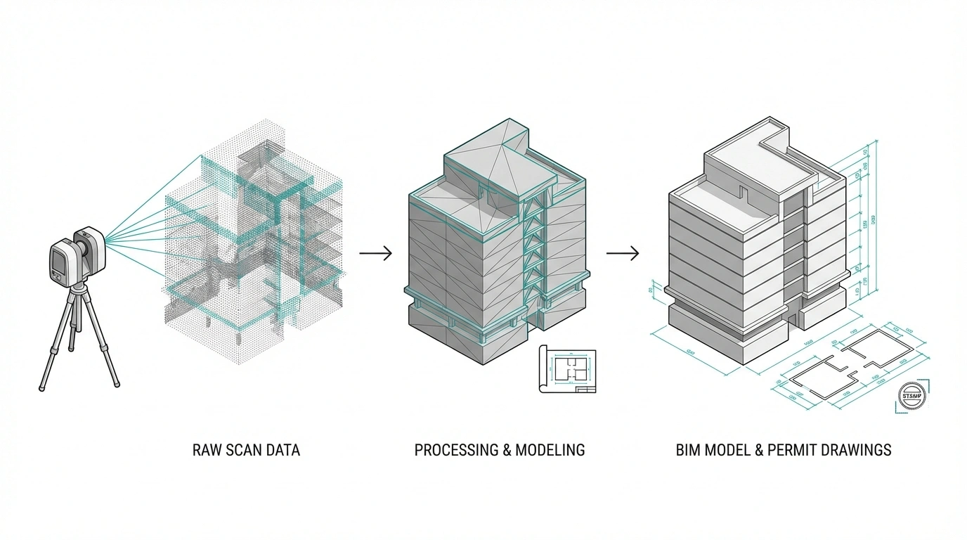
The raw output of a laser scan is a point cloud, but the true value lies in converting that data into usable construction documentation, a process known as "Scan to BIM."

Scan-to-BIM process workflow from point cloud capture to construction documentation

Streamlining building permit drawings

In the City of Vancouver, obtaining a building permit requires strictly adherent documentation. Submitting building permit drawings based on vague manual measurements can lead to rejection and delays. 3D laser scanning providers can generate "digital twins" that serve as the single source of truth, allowing for the extraction of:

  • 2D floor plans: exact layouts showing current wall thicknesses.
  • Elevations and sections: slices through the building that reveal vertical relationships.
  • Reflected ceiling plans: crucial for lighting and mechanical coordination.

BC Building Code compliance

Compliance with the BC Building Code is non-negotiable. Whether calculating the rise and run of a heritage staircase or determining the glazed area of a facade, data from a 3D scan provides the forensic level of detail required for code analysis. This is particularly relevant for "change of use" projects requiring a rigorous feasibility scan.

Real estate and property management applications

The utility of 3D laser scanning in Vancouver extends beyond construction into real estate sales and property management.

The RMS vs. architectural measurement debate

In the real estate world, accurate square footage is currency. Discrepancies often arise between different measurement standards (RMS vs. Architectural). Real estate floor plans derived from laser scanning provide an objective, indisputable dataset. If a dispute arises regarding the leasable area (BOMA standards), the point cloud serves as a forensic record that can be re-measured without re-visiting the property.

Heritage preservation: digitizing Vancouver's history

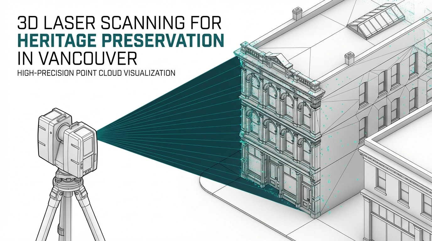
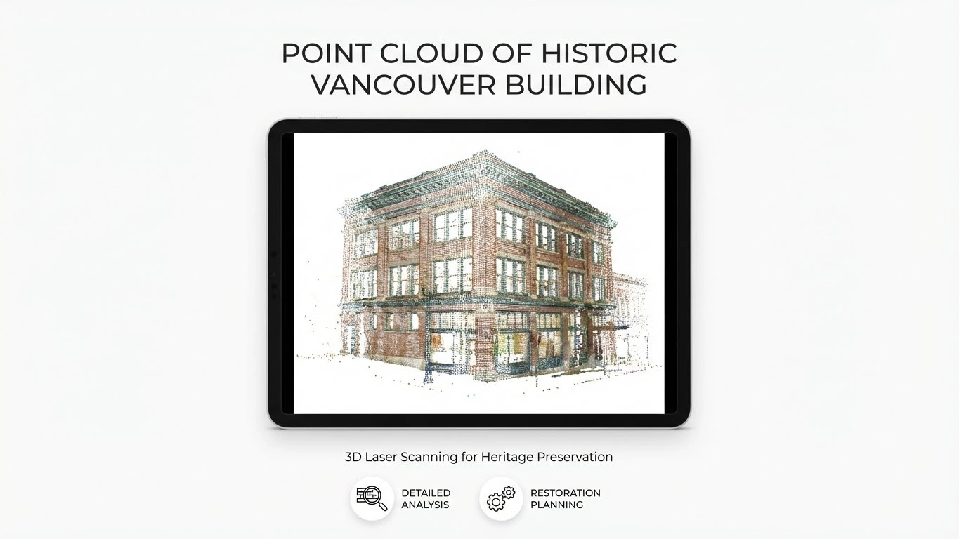
Vancouver takes pride in its heritage structures, from the Victorian homes of Strathcona to the brick warehouses of Yaletown. 3D laser scanning in Vancouver is the preferred method for heritage documentation because it is non-intrusive. Scanners can capture intricate details of cornices and masonry patterns, creating a "digital archive" for faithful restoration.

Vancouver heritage building documented as a precise 3D point cloud

The cost-benefit analysis: is it worth it?

A common hesitation among property owners is the perceived cost of 3D laser scanning services. While the upfront cost is higher than a manual survey, this view is myopic.

The cost of error

Consider the cost of a single error in renovation planning. If a custom staircase is ordered based on a measurement off by 25 mm, the cost of the delay and material waste far exceeds the cost of the initial scan. By providing accurate contractor estimates and reducing change orders, laser scanning is an insurance policy against the unknown.

Choosing the right 3D laser scanning provider in Vancouver

Not all scanning is created equal. When selecting a partner, look for providers who understand both the technology and the local construction environment.

  • Equipment quality: ensure the provider uses high-end terrestrial scanners (like Leica or Trimble) rather than consumer-grade tools.
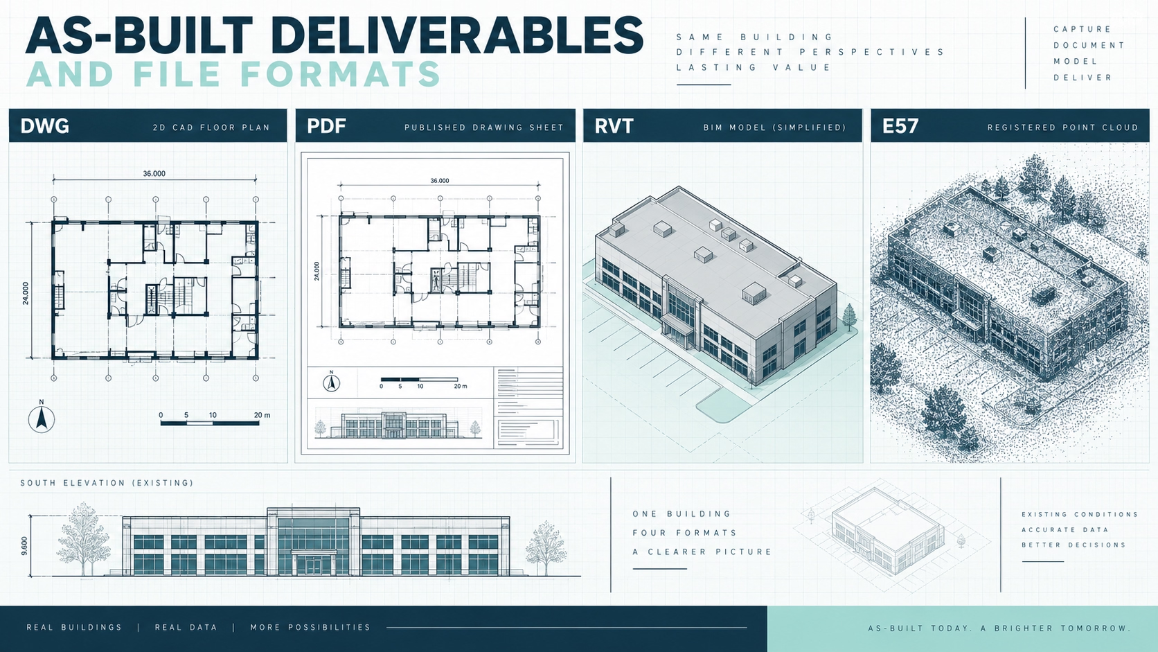
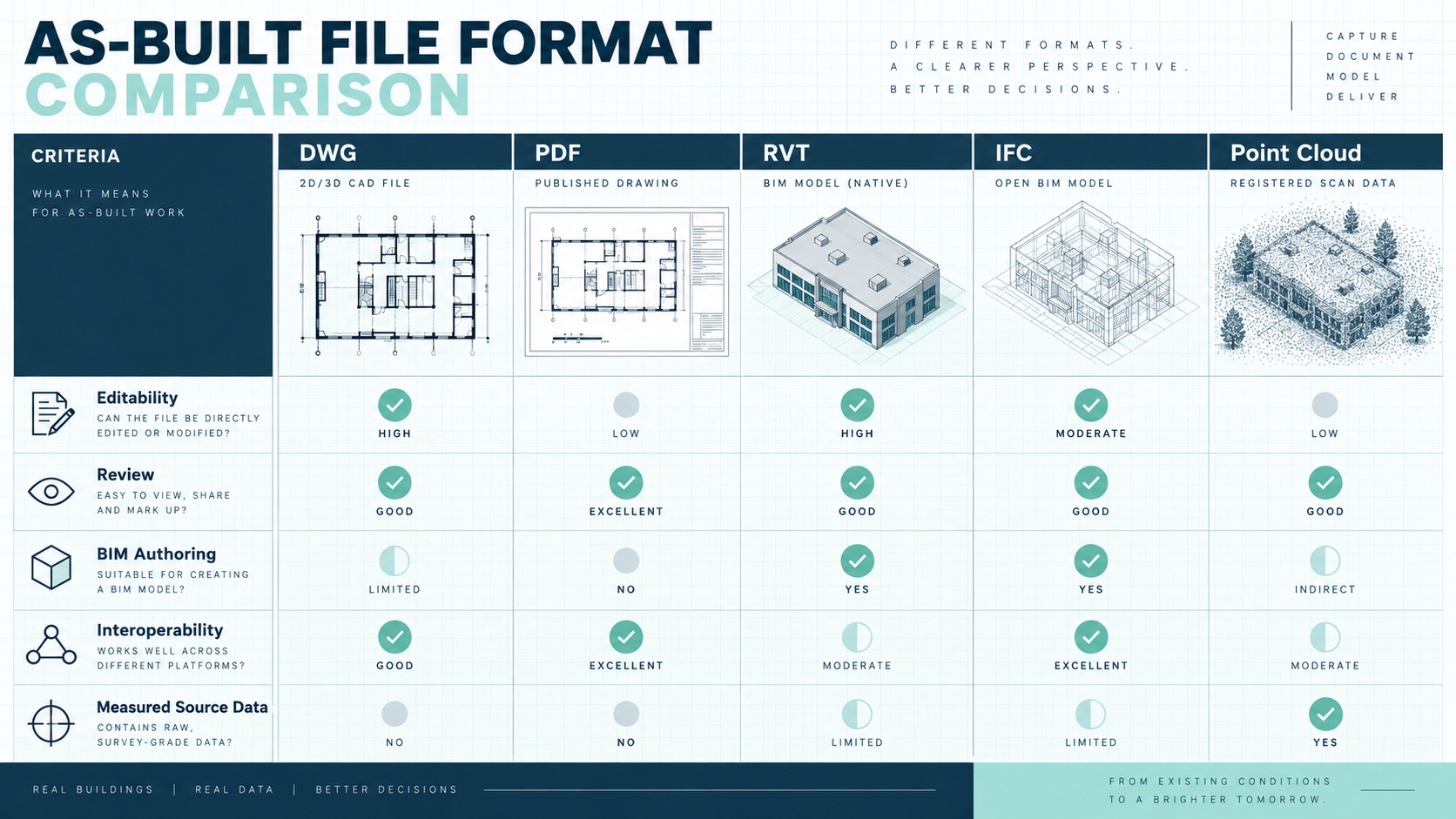
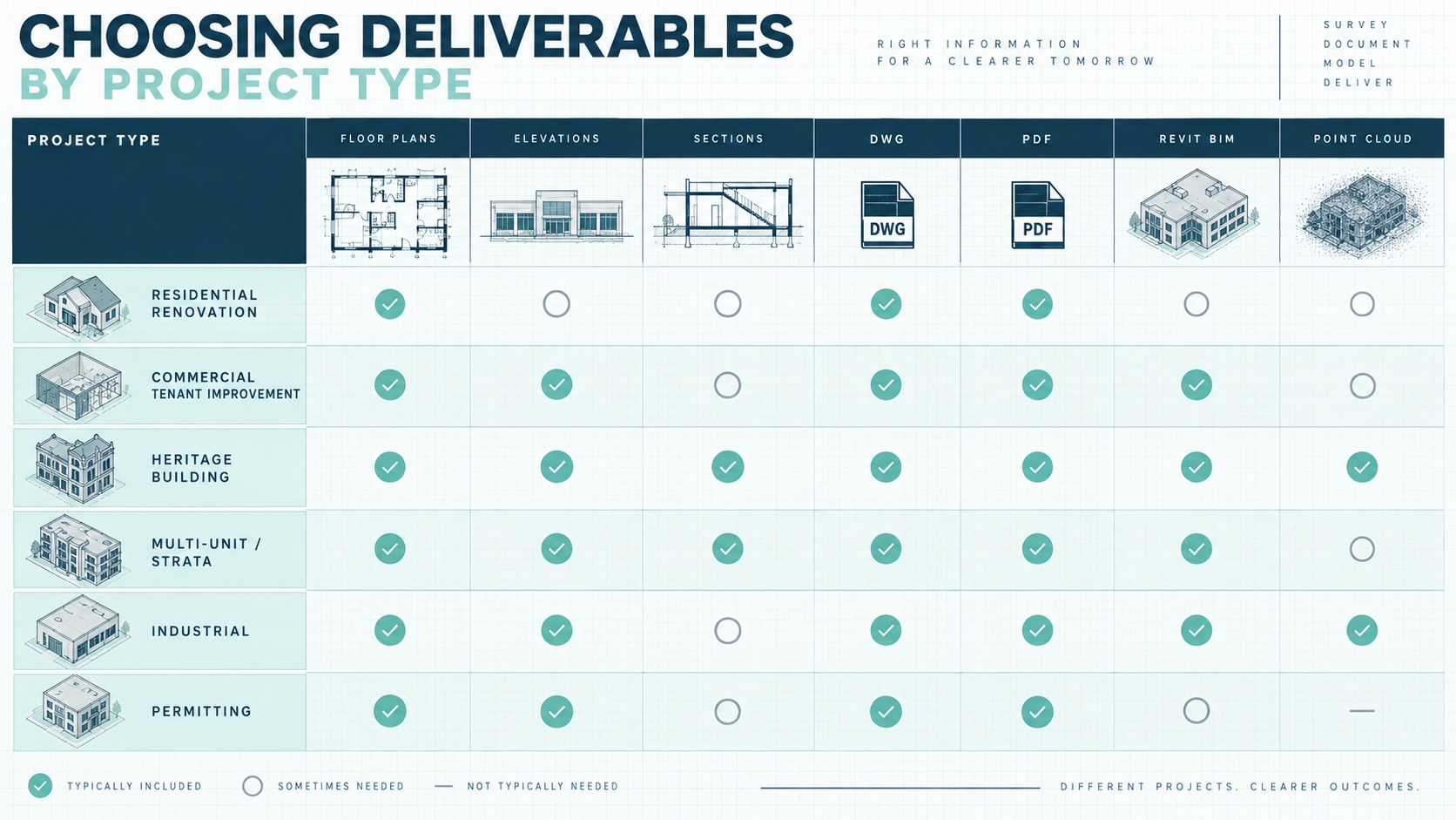
  • Deliverable formats: ensure they can provide the specific file types you need (RCP for Revit, DWG for AutoCAD, or PDF).
  • Experience: look for teams with a track record in home renovation in Greater Vancouver or commercial retrofits.

3D Laser Scanning in Vancouver: Precision for AEC Projects

In the fast-moving world of architecture, engineering, and construction (AEC), accuracy is not just a preference – it is an absolute requirement. Whether you are a property owner planning a major home renovation or a professional managing a complex commercial retrofit, every successful project begins with a clear understanding of a building's existing conditions. Today, 3D laser scanning in Vancouver has revolutionized as-built measurements by leveraging cutting-edge LiDAR (light detection and ranging) systems and Scan-to-BIM workflows. By capturing millions of precise data points within minutes, professionals can now create a digital foundation for accurate floor plans, building permit drawings, and complex construction documentation.

A colorized point cloud visualization created via 3D laser scanning in Vancouver

3D laser scanner capturing a construction site for accurate existing-condition documentation

The evolution of as-built measurements in the AEC industry

Historically, as-built measurements were taken manually using tape measures, rulers, and hand-drawn sketches. While these methods served their purpose for decades, they were inherently time-consuming, prone to human error, and limited in their overall scope. In our ten years of providing 3D laser scanning services, we have learned that the biggest client concern isn't actually about the technology – it is about trust. An architect designing a multi-million-dollar hospital renovation needs to be certain that the documentation they are working from is flawless.

Outdated blueprints and manual measurement errors are not just inconvenient; they lead to costly rework, project delays, and significant financial risk. Traditional building measurements rely on rough sketches and hours of on-site work that often result in discrepancies. 3D laser scanning in Vancouver replaces this uncertainty with precision, capturing detailed information about a building's layout in a remarkably short amount of time.

Across Vancouver and the Greater Vancouver Area, reality capture technologies provide faster, safer, and more reliable documentation for interior designers, contractors, and property managers. We are seeing a permanent shift in how the industry documents existing conditions, moving away from antiquated tools and toward a digital-first approach.

Understanding the technology: how a 3D scanner in Vancouver works

At its core, 3D laser scanning – also known as high definition surveying (HDS) – is a non-contact, non-destructive method of mapping surfaces. A professional 3D scanner in Vancouver works by firing thousands, or even millions, of laser pulses per second at physical surfaces. These pulses bounce back to the scanner, where sensors calculate the "time-of-flight" and the angle of return to determine precise spatial coordinates.

LiDAR vs. traditional surveying

LiDAR is the underlying technology that measures distance by illuminating a target with laser light. When these measurements are combined, they create a point cloud – a dense collection of millions of individual data points, each with its own x, y, and z coordinate. Unlike a simple photograph, this point cloud provides a millimeter-accurate digital replica of the real-world asset.

While traditional tools like total stations provide high accuracy, they require significant setup time and point-by-point manual selection. In contrast, a modern terrestrial 3D scanner in Vancouver captures the entirety of an environment, ensuring that no critical architectural or structural detail is omitted. This technology allows us to capture the "snapshot of current conditions" with the highest resolution of measurable detail currently available to engineering projects.

LiDAR versus manual measurement comparison for building documentation

The benefits of professional 3D laser scanning services

Choosing professional 3D laser scanning services over traditional methods offers tangible benefits that directly impact a project's bottom line. The investment in a 3D scan often pays for itself many times over by providing accurate data upfront and helping teams avoid delays.

Millimeter-level accuracy

The primary advantage of building scanning is unmatched precision. Professional systems can deliver data typically accurate to within 1-5 mm, eliminating the guesswork associated with manual measurements. This level of detail is critical when retrofitting new equipment into tight spaces or when regulatory compliance depends on exact dimensions.

In Vancouver, where many homes and commercial buildings are older or complex, subtle deviations – like warped walls or offset windows – can be captured with precision. This allows professionals to detect deviations between the "as-built" condition and the original "as-designed" CAD models through color-coded analysis.

Reducing fieldwork and site visits

3D laser scanning in Vancouver can reduce fieldwork time by up to 70%. A single technician can scan tens of thousands of square feet in a day, a task that would take a traditional survey crew weeks. This efficiency limits the number of times a measurement team needs to revisit a site, which is especially valuable for active facilities like hospitals or retail stores.

Furthermore, having a complete environment capture allows architects and designers to "virtually visit" a site from their office. These virtual walkthroughs are an interior designer's tools of choice, allowing them to verify measurements or view architectural details without leaving their desk.

Enhanced safety and accessibility

Laser scanning is a non-contact technology, allowing data capture from a safe distance. This is crucial when documenting hazardous areas, high ceilings, or inaccessible structures such as steep cliffs or busy intersections. In industrial settings, scanners can document zones without putting personnel at risk, such as near high-voltage electrical facilities or in confined spaces.

The Scan-to-BIM workflow: a roadmap to precision

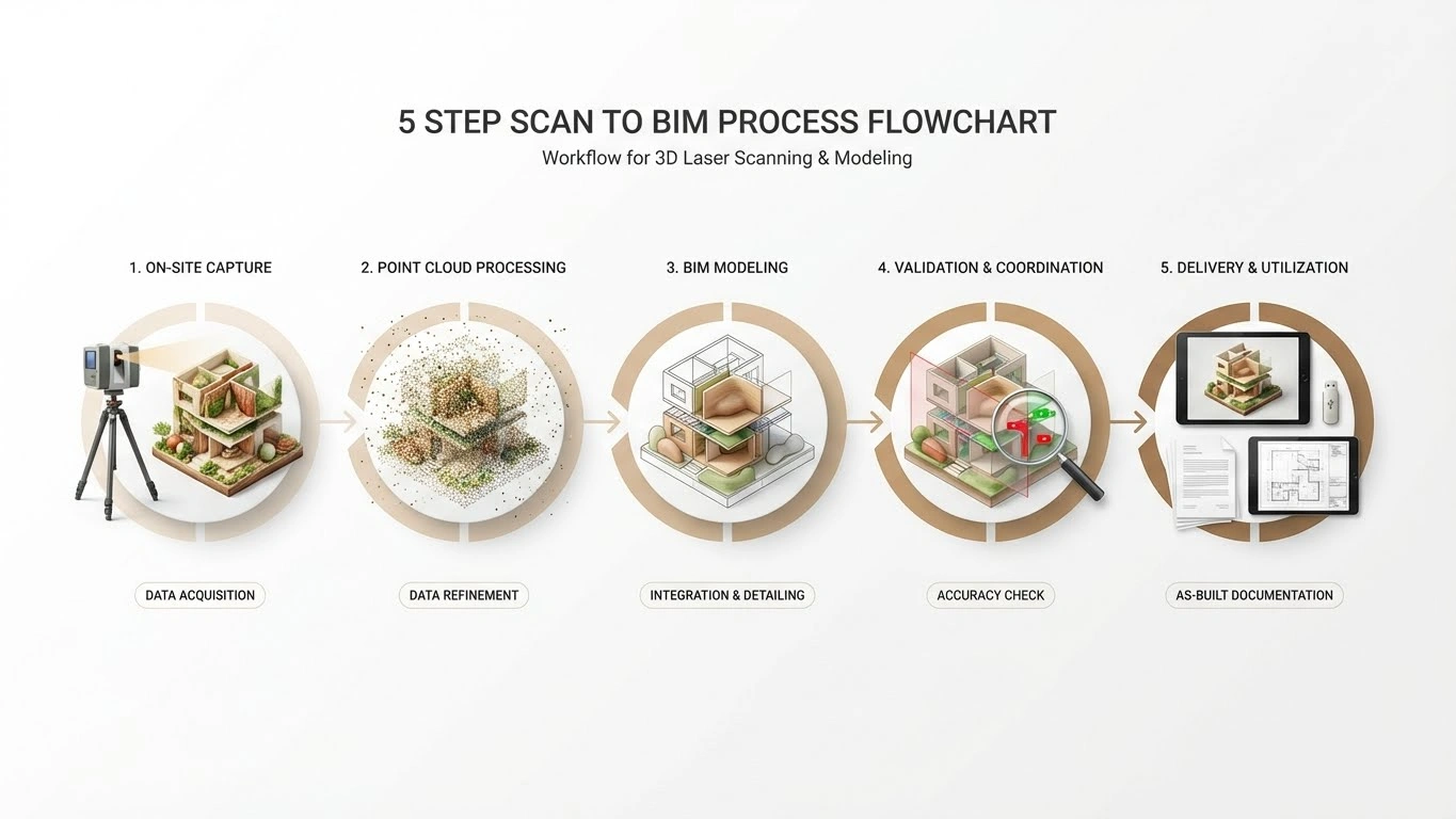
Transforming raw scan data into actionable insights involves a structured five-step process that ensures quality and consistency.

  1. 1. Project consultation and planning: Every project starts with a detailed consultation to understand the client's goals and define the required scope. This planning phase is essential for renovation planning, as it helps establish the "single source of truth" for the entire project team.
  2. 2. On-site data capture: Technicians deploy to the site with state-of-the-art equipment to systematically scan the area, ensuring complete coverage and overcoming shadows.
  3. 3. Data processing: Individual scans are cleaned, aligned, and "registered" into a unified point cloud. Specialized software filters out "noise" to ensure geometric integrity.
  4. 4. Modeling and deliverable creation: The modeling team transforms the point cloud into the desired deliverable, meticulously mapping data to BIM objects to create accurate floor plans.
  5. 5. Quality control and final delivery: Every deliverable undergoes rigorous checks to ensure accuracy before delivery in preferred formats.
Scan-to-BIM workflow from site capture and point cloud processing to final BIM deliverables

Beyond 2D: the power of building scanning for BIM and digital twins

While 2D drawings are still widely used, the industry is rapidly moving toward building information modeling (BIM). Scan-to-BIM is the process of converting point cloud data into an intelligent, data-rich 3D model.

Unlike a simple 3D model that only shows geometry, a BIM model includes metadata on materials, costs, and lifecycle information. These models are essential for:

  • Clash detection: identifying conflicts between new designs and existing systems.
  • Design validation: ensuring prefabricated components fit perfectly.
  • Digital twins: creating interactive replicas for facility management.

In the context of renovation planning, Scan-to-BIM significantly reduces errors and allows stakeholders to work from a shared knowledge resource throughout the building's lifecycle.

Applications across Vancouver's built environment

The versatility of 3D laser scanning in Vancouver makes it an indispensable asset across multiple sectors in British Columbia.

Home renovation in Greater Vancouver and residential projects

For a home renovation in Greater Vancouver, precision is the backbone of success. Accurate as-built documentation ensures that building permit drawings reflect actual site conditions, which is a requirement for local approvals. Homeowners and interior designers use these scans to fit custom cabinetry and fixtures without the fear of manual measurement errors. We have provided services for everything from single-family homes to large multi-family condo renovations, ensuring that every architectural detail is captured.

Heritage buildings and historic preservation

Vancouver's heritage properties require a sensitive, non-invasive approach to documentation. 3D scanning allows us to capture the intricate details of century-old churches and heritage homes for restoration and academic study. Because it is a non-contact technology, we can preserve the record of delicate historical surfaces and irregular geometries without causing any damage.

Industrial facilities and MEP coordination

Industrial sectors – including water treatment facilities and refineries – demand extreme precision. Building scanning provides the ideal solution for documenting complex piping systems and large machinery. By using laser scanning for MEP coordination, mechanical contractors can avoid the high cost of "field fitting" and ensure that prefabricated spools line up perfectly.

Commercial real estate and facility management

For the real estate sector, 3D laser scanning services provide real estate floor plans and virtual tours that are invaluable for marketing and leasing. Property managers also rely on these scans for BOMA-compliant area calculations, helping to maximize rentable area and optimize building performance.

The real cost of inaccuracy: why precision is project insurance

Inaccuracy in the planning phase can be incredibly expensive. Even a minor measurement error can ripple across a project, leading to:

  • Design conflicts: new systems interfering with existing elements.
  • Costly rework: errors that increase labor and material costs.
  • Permit delays: submissions being rejected due to inaccuracies.
  • Rework costs: accurate 3D scanning can cut project rework costs by 30% or more.

Consider a typical home renovation in Greater Vancouver: if a contractor discovers a plumbing line in a location not reflected in the drawings, the resulting delays can increase project costs by 15-20%. Investing in 3D laser scanning services upfront serves as a form of project insurance, providing the certainty needed to build with confidence.

Understanding costs and ROI for laser scanning services in Canada

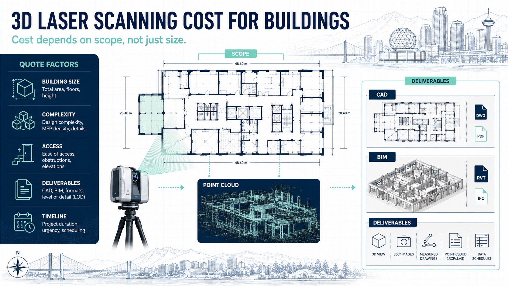
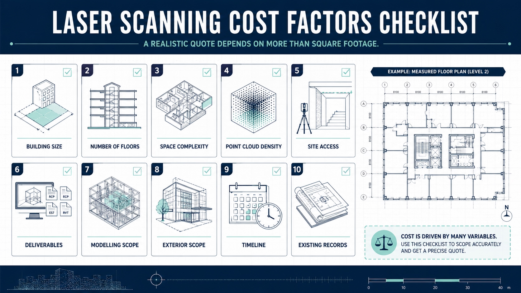
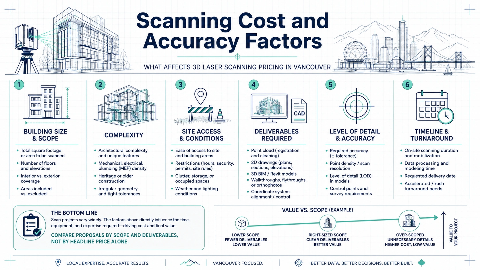
A common question for laser scanning services in Canada is the cost. While a definitive price requires a custom quote, the industry standard for commercial buildings typically ranges from $1.00 to $10.00 per square foot. Factors influencing the price include the size and complexity of the site, the required level of detail (LOD), and the final deliverables.

While there is an upfront investment, the return on investment (ROI) is significant. We have had clients calculate ROI ratios of 10:1 or higher when factoring in avoided errors and schedule acceleration. Catching just one major design conflict early can save a client over $150,000 in potential rework.

Choosing the right partner for 3D laser scanning in Vancouver

Not all scanning services are created equal. When choosing a provider for 3D laser scanning in Vancouver, look for a team with:

  • Proven experience: a track record of successful projects across sectors.
  • Advanced technology: use of high-end equipment like Trimble, Leica, or Faro scanners.
  • Comprehensive workflows: ability to handle everything from capture to BIM modeling.
  • Local expertise: deep understanding of Vancouver's unique architectural landscape and building codes.

Conclusion: measure once, build for a lifetime

The transition from tape measures to 3D laser scanning represents a fundamental shift in how we document and interact with the built environment. For professionals in Vancouver, these services offer the speed, precision, and safety required to navigate today's complex construction landscape. By establishing a reliable digital foundation at the start of a project, you can reduce risk, eliminate rework, and ensure that your vision is built correctly from start to finish.

Whether you are preparing for a complex industrial retrofit or a simple home renovation in Greater Vancouver, remember the golden rule of construction: Measure once, build for a lifetime. Precision is not just a technical detail – it is the strategic cornerstone of every successful build.

Choosing the Best 3D Scanning Vancouver Services: Leica vs. FARO vs. SLAM Technology

The architecture, engineering, and construction (AEC) sectors in Vancouver, BC increasingly rely on advanced reality capture technologies to ensure precision and streamline workflows. Modern 3D laser scanning has become a standard practice for capturing accurate, efficient spatial data of physical environments.

Whether you are a property owner planning a detailed home renovation in Greater Vancouver, a real estate professional requiring accurate documentation, or a contractor managing a complex commercial build, selecting the right 3D scanning Vancouver services is critical. This decision goes beyond hiring a service provider – it requires matching your project's accuracy requirements (millimeter vs. centimeter tolerance) with the appropriate technology, including Terrestrial Laser Scanners (TLS) from manufacturers such as Leica and FARO, or mobile SLAM (Simultaneous Localization and Mapping) systems.

The Essential Role of 3D Scanning in Vancouver's AEC Industry

3D scanning is no longer a luxury; it is an essential tool for high-quality project delivery and risk mitigation. Using LiDAR technology, scanners capture millions of spatial data points to create a highly accurate point cloud – a precise digital representation of existing conditions.

Vancouver 3D point cloud model created from professional laser scanning

These point clouds form the foundation for:

  • Accurate floor plans
  • Reliable as-built drawings
  • BIM models for design coordination

Across Vancouver's construction industry, 3D scanning improves accuracy, enhances collaboration, and reduces costly rework.

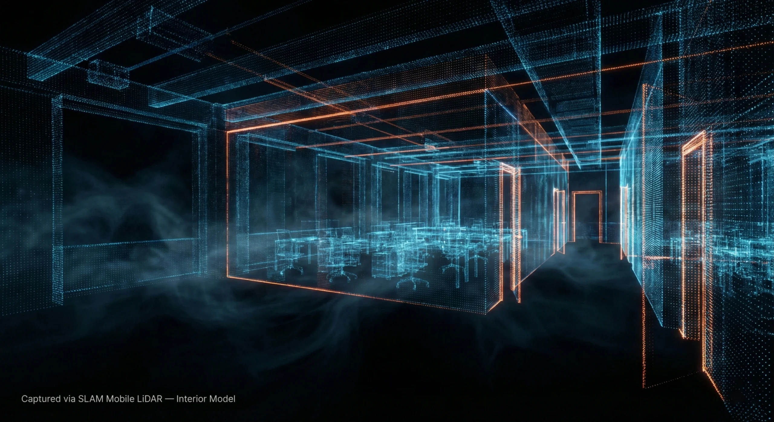
High-density 3D point cloud visualization of a building’s interior captured via mobile LiDAR scanning

Precision as the Foundation for Building Permit Drawings

For projects governed by strict provincial and municipal standards, accuracy is non-negotiable. High-quality 3D scanning significantly reduces human measurement error and supports smoother permitting and construction workflows.

Millimeter-level accuracy is critical when preparing building permit drawings, verifying as-built conditions against design intent, coordinating structural elements, and supporting sustainable construction strategies. Reliable scan data ensures that submitted documentation accurately reflects existing site conditions – an essential requirement for regulatory compliance.

Streamlining Renovation Planning and Contractor Estimates

3D scanning simplifies complex workflows for both residential and commercial projects throughout Greater Vancouver.

For homeowners and developers, scans create a precise digital twin of the space, fully compatible with as-built documentation. Interior designers rely on this data as advanced interior design tools, ensuring that millwork, cabinetry, and layouts fit precisely without costly field adjustments.

Contractors benefit from a highly detailed digital baseline that enables them to:

  • Produce accurate contractor estimates using reliable quantity take-offs
  • Improve coordination by identifying clashes between structural, mechanical, and plumbing systems before construction
  • Increase speed by capturing millions of data points in minutes rather than hours

Understanding the Core Technologies: TLS vs. SLAM

When selecting 3D laser scanning services in Vancouver, professionals must understand the two primary capture methodologies: Terrestrial Laser Scanning (TLS) and SLAM-based mobile scanning. The choice represents a fundamental trade-off between maximum accuracy and maximum speed.

Fixed-Point Terrestrial Scanners (TLS): The Accuracy Benchmark

TLS systems are mounted on a tripod and remain stationary during capture. They measure distance by calculating the time it takes for a laser beam to return to the scanner, delivering millimeter-level accuracy.

TLS is the preferred solution when:

  • Millimeter accuracy is required (industrial plants, structural analysis)
  • High point cloud density is necessary to capture fine surface detail
  • Controlled environments allow for multiple scan setups

SLAM Scanners: Prioritizing Speed and Mobility

SLAM technology emphasizes speed, flexibility, and mobility. Operators can walk continuously through a space using handheld, wearable, or backpack-mounted LiDAR systems.

Key characteristics include:

  1. 1. Real-time mapping using LiDAR sensors and inertial measurement units (IMUs)
  2. 2. Rapid data acquisition, often 5 – 10 times faster than tripod-based scanning
  3. 3. Operational flexibility in complex, multi-level, or GPS-denied environments

The Critical Trade-Off: Speed vs. Accuracy

TLS (Leica / FARO):

  • Accuracy: 1 – 2 mm
  • Capture Method: Stationary, multiple setups
  • Field Time: Longer
  • Drift Risk: Minimal

SLAM (BLK2GO / VLX):

  • Accuracy: 5 mm to 3 cm
  • Capture Method: Continuous mobile scanning
  • Field Time: 5 – 10× faster
  • Drift Risk: Possible over long distances

For structural verification and tolerance-sensitive applications, TLS remains the gold standard. For large-scale coverage and rapid as-built documentation, SLAM provides substantial efficiency gains. High-end systems such as the NavVis VLX 3 can achieve accuracies of 5 mm or better when tied to survey control.

Side-by-side comparison of Leica and FARO 3D scanners on a Vancouver construction site, highlighting

Leica vs. FARO: Terrestrial Scanning Leaders

Leica Geosystems: Precision and Performance

Leica is widely recognized for survey-grade accuracy. The Leica RTC360 is a flagship TLS scanner known for speed and data quality.

  • Accuracy: ~2 mm at 10 m
  • Speed: Fast colorized scans using Visual Inertial System (VIS)
  • Data Quality: Dense, low-noise point clouds with high-quality HDR imagery

FARO Technologies: Versatility and Value

FARO scanners balance performance and cost, making them popular across a wide range of projects.

  • Accuracy: Within a few millimeters
  • Range: Up to 350 m (Focus Premium)
  • Software: Strong CAD and BIM integration via FARO Scene

Portable TLS: Leica BLK360 G2

Compact TLS units like the Leica BLK360 G2 bridge the gap between mobility and accuracy.

  • Lightweight and portable (≈850 g)
  • Rapid 360° scans (~20 seconds)
  • Ideal for interiors, real estate floor plans, and fast site documentation

Professional using Leica RTC360 scanner on a commercial site in Vancouver to capture high-accuracy p

The Rise of SLAM for Home Renovation Projects in Greater Vancouver

Mobile SLAM scanning represents a paradigm shift in efficiency. By capturing data while walking through a space, field time is dramatically reduced – making SLAM ideal for large residential renovations and interior-heavy projects.

Leading SLAM Systems

  • Leica BLK2GO: Handheld, fast capture, lower point density
  • NavVis VLX 3: Wearable system delivering up to 1.28 million points per second with survey-grade accuracy
  • FARO Orbis: Hybrid solution combining mobile SLAM with stationary flash scans

SLAM handheld scanner being used to map the interior of a residential property in Vancouver for fast

Practical Applications: Matching Technology to Project Needs

High-Accuracy Projects

  • Structural quality control
  • Heritage documentation
  • Detailed MEP and industrial scanning

Speed-Focused Projects

  • Real estate floor plans
  • Preliminary renovation layouts
  • Facility management and large interiors

Hybrid Workflows: Best of Both Worlds

Experienced 3D scanning Vancouver service providers often combine technologies:

  • TLS scans anchor critical geometry
  • SLAM captures large areas quickly
  • Integrated datasets deliver both accuracy and efficiency

Selecting the Right 3D Scanning Vancouver Services Partner

Technology alone is not enough – operator expertise is equally critical. A qualified provider brings:

  • AEC experience and local knowledge
  • Clear understanding of accuracy requirements
  • Deliverables optimized for CAD, BIM, and permit submissions

Conclusion

Choosing the right 3D scanning solution in Vancouver depends on balancing accuracy, speed, and cost. Leica and FARO TLS systems deliver industry-leading precision, while SLAM technology offers unmatched efficiency. The most effective outcomes are achieved through hybrid workflows, guided by experienced professionals who understand how to align technology with project goals.

Mobile LiDAR Scanning in Vancouver: Why SLAM 100 Is the Go‑To Solution for Complex Sites

In the dynamic and often structurally complex landscape of Vancouver's built environment, traditional methods of site measurement are increasingly proving inadequate for the speed and precision demanded by modern construction and renovation planning. The industry now requires a solution capable of generating highly detailed, accurate spatial data efficiently. This imperative has solidified the position of mobile LiDAR scanning in Vancouver as the leading methodology for reality capture. Handheld devices, such as the SLAM 100, deliver exceptional 3D laser scanning services, turning complicated, feature-rich sites – from sprawling high-rise developments to intricate Victorian heritage homes – into quantifiable, actionable data, including highly accurate floor plans, elevations and site plans.

The technological edge: how SLAM revolutionizes mobile LiDAR scanning in Vancouver

LiDAR (Light Detection and Ranging) technology uses laser pulses to measure distances and create precise 3D point clouds of spaces, assets, and objects. While LiDAR systems have long been essential instruments in surveying, the revolutionary development was the creation of portable and lightweight handheld devices. These portable LiDAR scanners integrate sophisticated algorithms, marking a significant leap in efficiency, speed, and accuracy for building documentation.

The core of this efficiency lies in the technology known as Simultaneous Localization and Mapping (SLAM).

Defining SLAM: localization and mapping in real-time

SLAM is a transformative technology that allows mobile systems to simultaneously build and update a map of their surrounding environment while precisely determining their location within that map. Originally developed for robotics, SLAM has been successfully implemented across various surveying applications, ranging from handheld scanners and backpack systems to vehicle-mounted and drone applications.

Handheld laser scanners equipped with SLAM technology capture detailed 3D maps in real-time. These scanners measure distances using laser beams to create point clouds that represent the environment. The SLAM algorithms continuously process this data to identify unique features and landmarks, constantly updating the map as the operator moves. This continuous feedback loop ensures that the scanner accurately maintains its location within the mapping system, even when navigating complex and dynamic settings.

The best mobile mapping systems utilize a combination of LiDAR and RGB cameras to capture a densely colored, photorealistic 3D dataset of the structure. This data is intuitive to navigate, explore, and measure, even for stakeholders unfamiliar with traditional point clouds. Crucially, leading mobile mapping devices provide real-time feedback via a tablet display, showing the quality of the capture as the work is being performed. If an area is missed, the screen immediately indicates this, allowing the operator to correct the scan on the spot.

Mobile LiDAR scanning of a Vancouver urban building with real-time 3D capture

Superior accuracy in challenging environments

Handheld SLAM systems offer high precision, making them valuable tools for obtaining precise and accurate data with minimal effort. The output of sophisticated SLAM technology can be highly detailed 3D point clouds, with a point spacing density comparable to terrestrial laser scanning (TLS), sometimes reaching 2 mm spacing.

The SLAM 100, specifically, delivers impressive results, achieving:

  • Relative accuracy: up to 2 cm.
  • Absolute accuracy: up to 5 cm.

These systems are capable of producing georeferenced survey-grade accuracy after post-processing and geo-referencing, typically ranging from 6-15 mm for absolute accuracy depending on the environment and processing method. This level of precision is critical for professional applications such as LOD 300 BIMs or floor plans rendered at a scale of up to 1:50.

Handheld SLAM vs. terrestrial laser scanning: a workflow comparison

For complex sites and large assets, the adoption of handheld SLAM LiDAR is driven primarily by efficiency gains relative to traditional static Terrestrial Laser Scanning (TLS).

Comparison of key features:

  • Mobility: handheld units easily navigate tight, complex, or hard-to-reach areas, whereas TLS is typically stationary.
  • Setup time: SLAM devices are designed for rapid deployment and dynamic movement, unlike TLS which requires multiple setups and calibration.
  • Data capture: handheld devices allow for rapid mobile mapping, capturing massive data swathes on the go.
  • Real-time output: SLAM provides immediate 3D visualization and mapping feedback during the scan, while TLS data registration is typically performed after field work.

The most compelling argument for adopting mobile LiDAR scanning in Vancouver is the dramatically reduced time required on-site.

GPS-independent mapping: conquering urban canyons

A significant benefit of SLAM-based laser scanners is their ability to survey effectively in environments where Global Positioning System (GPS) signals are degraded or entirely unavailable. SLAM systems function independently of GPS.

This makes mobile scanning in Vancouver ideally suited for challenging regional infrastructure and properties, including:

  • Indoor spaces and basements: SLAM systems perform real-time mapping in enclosed spaces where GPS is unavailable.
  • Tunnels and underground spaces: the SLAM 100 has been used for capturing data in underground spaces and metro tunnels, eliminating the need for splicing operations.
  • Urban canyons: in dense urban areas like downtown Vancouver, high-rise buildings often hinder GPS signals, but SLAM maintains accurate localization.
  • Industrial facilities: complex manufacturing plants often have obstructed views and challenging geometries.

Furthermore, LiDAR-based SLAM systems are capable of operating with little to no light, making them perfect for inspections or surveying hard-to-reach areas during off-hours.

GPS-independent mapping: conquering urban canyons

A significant benefit of SLAM-based laser scanners is their ability to survey effectively in environments where Global Positioning System (GPS) signals are degraded or entirely unavailable. SLAM systems function independently of GPS.

This makes mobile scanning in Vancouver ideally suited for challenging regional infrastructure and properties, including:

  • Indoor spaces and basements: SLAM systems perform real-time mapping in enclosed spaces where GPS is unavailable.
  • Tunnels and underground spaces: the SLAM 100 has been used for capturing data in underground spaces and metro tunnels, eliminating the need for splicing operations.
  • Urban canyons: in dense urban areas like downtown Vancouver, high-rise buildings often hinder GPS signals, but SLAM maintains accurate localization.
  • Industrial facilities: complex manufacturing plants often have obstructed views and challenging geometries.

Furthermore, LiDAR-based SLAM systems are capable of operating with little to no light, making them perfect for inspections or surveying hard-to-reach areas during off-hours.

Unlocking efficiency for home renovation projects in Greater Vancouver

For architects, interior designers, and contractors tackling home renovation projects in Greater Vancouver, the initial site assessment is the foundation of success. Errors introduced at the measurement stage propagate throughout design, procurement, and construction, leading to costly delays. Handheld LiDAR scanning mitigates these risks by providing an immediate, verifiable digital record of existing conditions.

From existing conditions to accurate floor plans

The speed and portability of handheld scanners drastically reduce the time needed to capture existing conditions. This is particularly advantageous for retrofitting and restoration projects where precise measurements are paramount.

By creating detailed 3D models of the structure, professionals can quickly generate accurate floor plans and elevation data. These accurate data sets simplify the process of understanding topography and identifying potential issues like uneven ground before renovation planning begins.

Key advantages for floor plan generation:

  • Comprehensive view: handheld scanners can capture both the exterior and interior of a building, providing a thorough view.
  • High detail: the capability to achieve millimeter-level density in point clouds means fine architectural details are preserved.
  • Digital deliverable: the output is typically compatible with industry-standard file formats (such as LAS and E57) and can be easily imported into preferred design software.
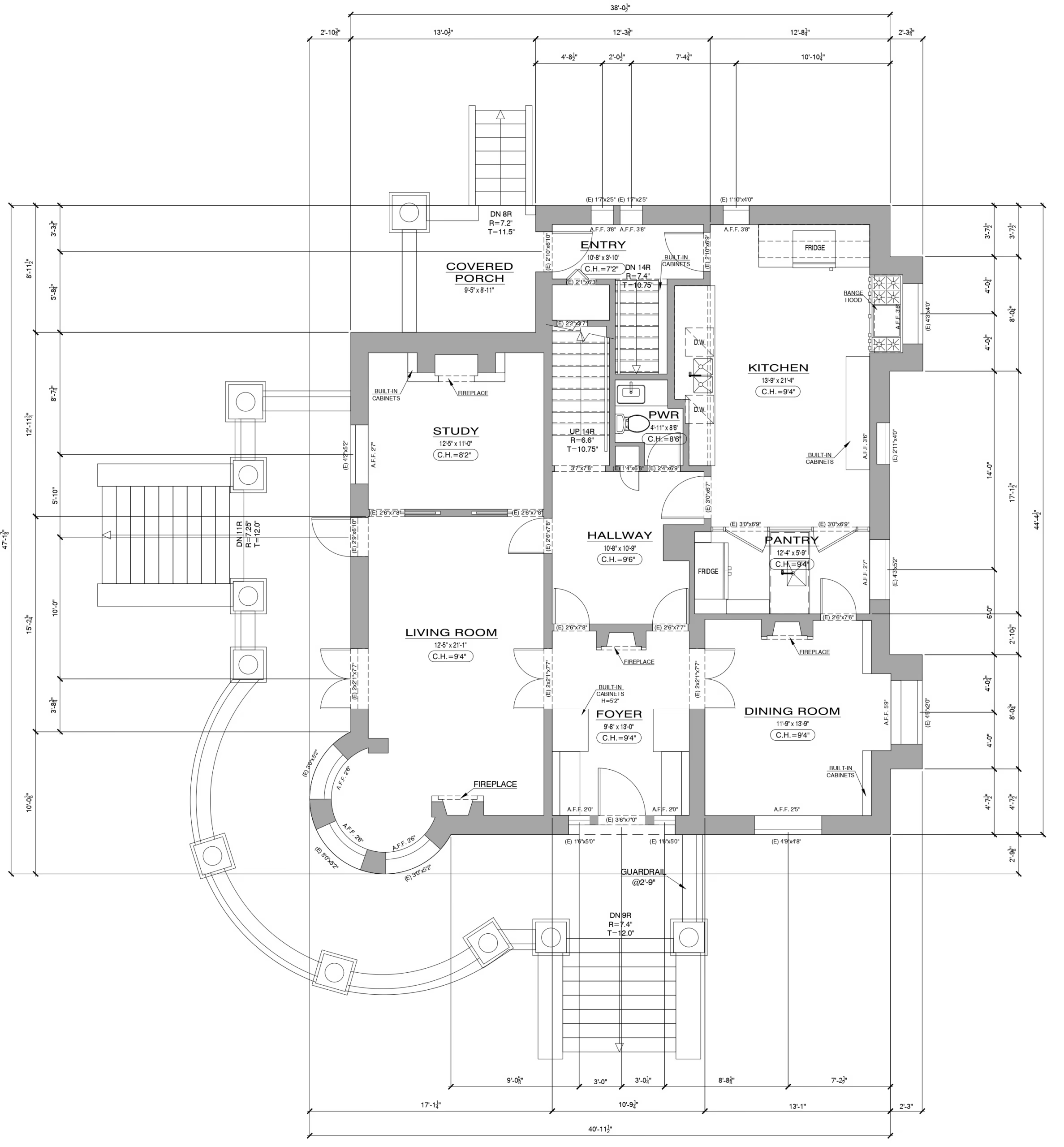
As-built floor plan generated from mobile LiDAR scanning data

Streamlining renovation planning and design

Renovation planning demands a meticulous understanding of what currently exists versus what is intended. Handheld LiDAR scanners accelerate the initial site assessment and data preparation phases, directly leading to faster project delivery.

Mobile scanning systems integrate effectively with Building Information Modeling (BIM) workflows. The generated 3D data, often referred to as "Scan-to-BIM," allows architects and engineers to:

  • Create digital twins: use collected data to build a virtual model of the site, assisting in designing new structures that fit perfectly with the existing topography.
  • Informed decisions: integration into BIM systems provides more precise and informed design decisions, minimizing clashes and structural conflicts.
  • Reduced modeling time: industry reports suggest that integrating mobile scanning with BIM workflows can reduce modeling time by up to 60% on complex renovation projects.

Critical advantages for professionals: architects, designers, and contractors

The versatility and high-definition output of devices like the SLAM 100 make them essential interior designer tools and invaluable for construction professionals focused on efficiency and cost control.

Empowering interior designer tools and vision

Interior design often hinges on maximizing tight tolerances and understanding volumetric constraints, especially in older Vancouver homes. The ability to capture detailed 3D models quickly allows interior designers to integrate their vision with real-world dimensions instantly.

The SLAM 100 includes three 5MP cameras designed to synchronously capture texture information, allowing for the creation of color point clouds and partial panoramic images. This photorealistic documentation is crucial for design presentations and client engagement.

Designers can utilize this data for:

  • Accurate volume measurement: capturing volume data for material estimation and layout planning.
  • Virtual walkthroughs: generating 360° virtual tours from the mobile mapping device.
  • Feature-rich models: utilizing high-resolution point clouds to detect and model architectural features (millwork, niches) that influence design decisions.

Enhancing contractor estimates and project management

Contractors operate in a highly competitive market where accurate pricing and timely project completion are paramount. The reliability of precise measurements derived from mobile LiDAR scanning in Vancouver directly translates into superior project management.

Handheld LiDAR dramatically improves the reliability of contractor estimates by:

  • Minimizing unknowns: accurate spatial data eliminates guesswork associated with manual measurements, reducing the risk of material overages.
  • Faster estimation cycles: the rapid capture speed reduces the lead time required to gather measurement data, allowing contractors to produce timely and competitive bids.
  • Quality control checks: regular scanning during construction monitors progress and ensures adherence to design specifications, enabling quick identification and correction of deviations.

Construction documentation and compliance

For both large-scale commercial builds and detailed home renovation projects in Greater Vancouver, robust construction documentation is non-negotiable, particularly when dealing with municipal requirements for building permit drawings and final inspections.

SLAM LiDAR scanners support stringent documentation standards throughout the entire project lifecycle:

  1. 1. Initial site assessment: detailed terrain mapping ensures new construction does not interfere with surrounding elements.
  2. 2. During construction: regular scanning tracks construction progress against the timeline and design specs. LiDAR scanners detect deviations from the planned design, enabling rapid corrective actions.
  3. 3. Post-construction: LiDAR scanning delivers a detailed view of the finished structure, essential for final inspections and construction documentation.
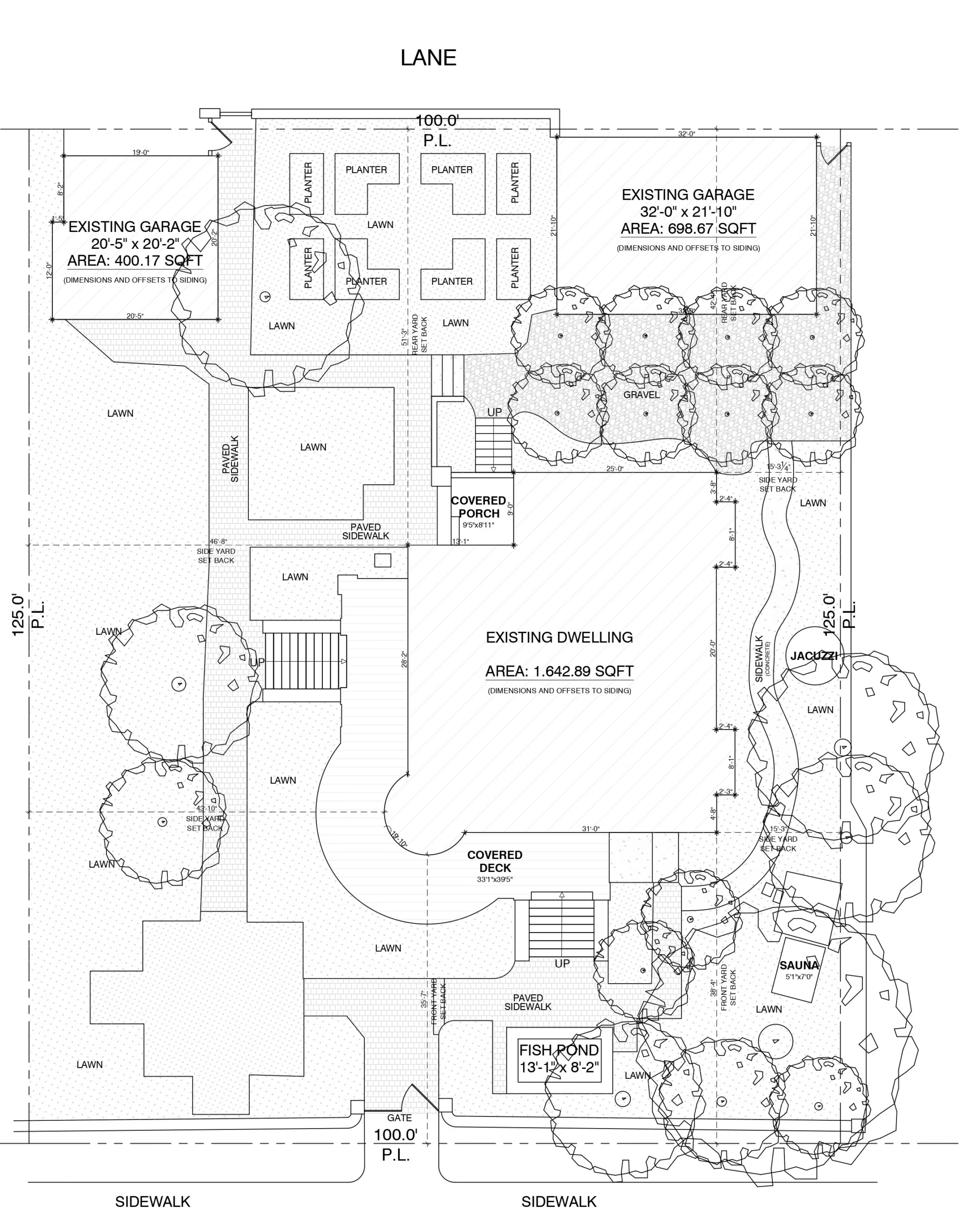
Site plan created from accurate mobile LiDAR survey data

While the sources do not specifically cite the BC Building Code, the detailed, high-accuracy deliverables provided clearly align with the high standards of spatial documentation required for municipal building permit processes.

The SLAM 100 advantage: technical specifications and performance

The SLAM 100 Industrial Handheld 3D LiDAR Mobile Laser Mapping Scanner System is a powerful example of mobile mapping technology designed for obtaining high-precision data in complex environments.

Precision data capture features:

  • Rotating head: includes a 360° rotating head providing a comprehensive 270°x360° point cloud coverage.
  • LiDAR range: utilizes a 16-channel laser head with a range of up to 120 meters and a point generation rate of 320,000 points per second.
  • Integrated cameras: three integrated 5MP cameras synchronize texture information capture, forming a horizontal 200° Field of View.
  • Portability: lightweight and compact design operating on internal batteries for up to 2.5 hours.

Software ecosystem:

The efficiency of mobile LiDAR scanning in Vancouver is enhanced by the integrated software ecosystem. The SLAM GO App connects to the scanner for real-time data display (3D/2D) ensuring high-quality acquisition. SLAM GO POST PRO software performs high-precision point cloud mapping, optimization, and panoramic image generation.

Accelerating real estate and permit processes

The Vancouver real estate market demands swift and precise documentation. Mobile LiDAR scanning benefits property owners by accelerating the provision of essential documents like real estate floor plans.

Generating real estate floor plans quickly

Accurate floor plans are paramount for marketing and legal documentation. Handheld SLAM scanners drastically shorten the time from site visit to finalized documentation.

  • Minimal disruption: handheld mapping is less intrusive and remarkably fast, beneficial in sensitive urban environments.
  • Rapid delivery: a building can be scanned and a detailed 3D model generated in a fraction of the time required by manual methods.
  • Intuitive visuals: resulting photorealistic 3D models provide realistic site reproduction, offering a better data carrier for virtual tours.

Supporting building permit drawings with reliable data

The foundation of any successful municipal application in Greater Vancouver is accurate building permit drawings based on verifiable site conditions.

  • Survey-grade accuracy: post-processed point clouds can be geo-referenced to survey-grade accuracy.
  • Detailed documentation: millions of data points provide definitive as-built documentation.
  • Change analysis: mobile scanning systems can analyze changes in real-time or post-facto to compare existing conditions against design models.
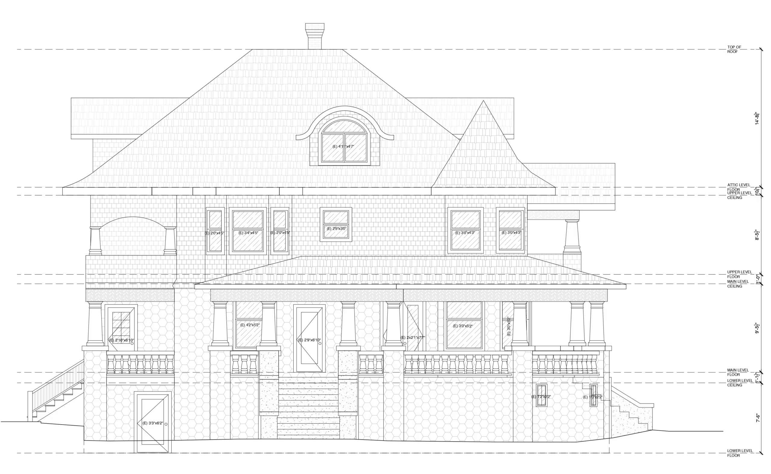
Existing elevations documented from precise 3D scanning data

Conclusion: the future of spatial data acquisition in Vancouver

For property owners, developers, architects, and the entire ecosystem supporting home renovation projects in Greater Vancouver, embracing handheld LiDAR technology marks a transition from approximate manual methods to definitive digital workflows. The SLAM 100 offers a solution that meets the highest demands of accuracy and speed required for complex projects.

By utilizing SLAM technology, professionals can generate accurate floor plans and robust construction documentation quickly and reliably, even in GPS-denied environments. These 3D laser scanning services are essential interior designer tools and provide the foundation for solid contractor estimates, streamlining renovation planning and the preparation of building permit drawings. The ability to deliver precise real estate floor plans rapidly also accelerates market activities and stakeholder coordination.

Large-Scale Accuracy: How Faro Focus Elevates Industrial 3D Scanning in Vancouver

The rapidly evolving landscape of construction and infrastructure management in Western Canada demands levels of precision that traditional measurement methods simply cannot deliver. In this high-stakes environment, where millimeter accuracy dictates project success and regulatory compliance, the adoption of advanced reality capture technology is not merely optional—it is mandatory. Specifically, the sophisticated capabilities of the Faro Focus laser scanner are transforming the standard practice for industrial 3D scanning in Vancouver. This technological shift provides experienced architects, general contractors, and facility owners with an invaluable digital toolset for planning, verification, and long-term asset management, ensuring that complex projects across the Lower Mainland meet the highest benchmarks of quality and efficiency.

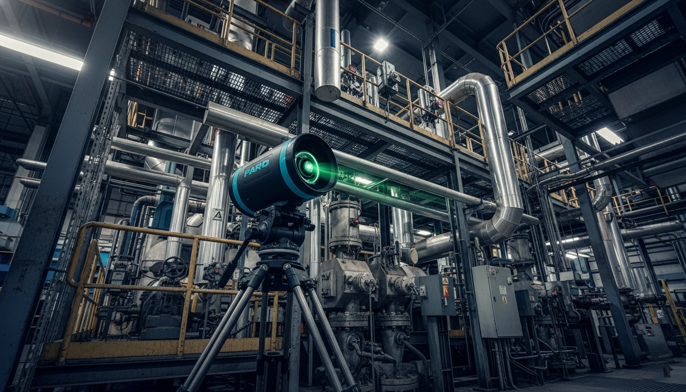
Faro Focus laser scanner mounted on a tripod, performing a 3D scan at a complex industrial site in Vancouver with visible pip

The new standard in reality capture: why Faro Focus technology dominates large-scale projects

For projects ranging from complex utility retrofits to high-rise construction monitoring, precision is the bedrock of constructibility. Faro Focus technology, often utilized in a comprehensive Faro Focus survey, has emerged as a leader in reality capture, providing highly accurate proximity data necessary for critical decision-making throughout the project lifecycle.

Traditional surveying relies on time-consuming, point-by-point measurements, which are inherently prone to human error and logistical constraints. In contrast, tripod-mounted laser scanners, such as the Faro Focus, capture millions of data points per second, resulting in a dense, comprehensive, and non-contact spatial record known as a point cloud.

Faro Focus industrial 3D scanning at a complex Vancouver industrial site

Precision beyond traditional methods

The value of this technology lies in its ability to capture the geometric characteristics of physical objects and environments with unparalleled detail. For large structures, mapping can achieve millimeter accuracies. Key characteristics demonstrating this superior precision include:

  • Massive data collection: high-definition surveying (HDS) equipment can measure tens of thousands of points per second, creating detailed 3D models of any object, structure, or terrain. A phase-based scanner can emit nearly a million laser points per second, collecting a 360-degree scan in minutes.
  • Comprehensive documentation: unlike manual surveys that risk omitting critical details, 3D laser scanning captures the entirety of an environment, ensuring that the final data set—the point cloud—is a complete snapshot of current conditions.
  • Accuracy for large volumes: the Faro Focus is particularly suited for scanning very large objects, such as houses or entire industrial plants, effectively combining individual 3D scans to overcome practical size limitations.

By delivering this level of geometric fidelity, a detailed Faro Focus survey provides the necessary confidence to execute projects requiring stringent dimensional control, limiting design conflicts and minimizing fit-up problems that often cause expensive construction rework.

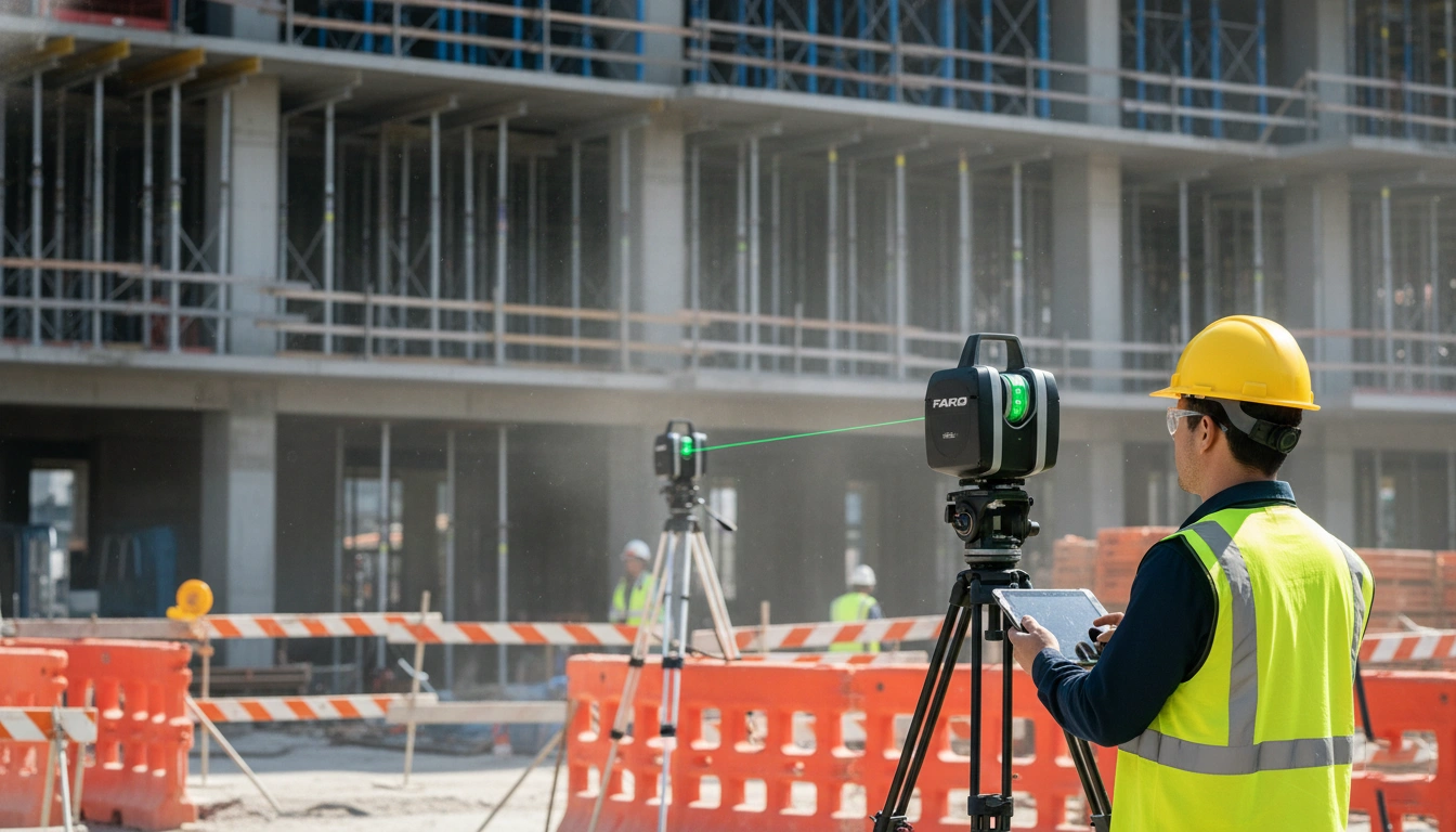
Technician using Faro Focus scanner from a safe distance on a busy Vancouver construction site, illustrating non-invasive 3D

The new standard in reality capture: why Faro Focus technology dominates large-scale projects

For projects ranging from complex utility retrofits to high-rise construction monitoring, precision is the bedrock of constructibility. Faro Focus technology, often utilized in a comprehensive Faro Focus survey, has emerged as a leader in reality capture, providing highly accurate proximity data necessary for critical decision-making throughout the project lifecycle.

Traditional surveying relies on time-consuming, point-by-point measurements, which are inherently prone to human error and logistical constraints. In contrast, tripod-mounted laser scanners, such as the Faro Focus, capture millions of data points per second, resulting in a dense, comprehensive, and non-contact spatial record known as a point cloud.

Faro Focus industrial 3D scanning at a complex Vancouver industrial site

Precision beyond traditional methods

The value of this technology lies in its ability to capture the geometric characteristics of physical objects and environments with unparalleled detail. For large structures, mapping can achieve millimeter accuracies. Key characteristics demonstrating this superior precision include:

  • Massive data collection: high-definition surveying (HDS) equipment can measure tens of thousands of points per second, creating detailed 3D models of any object, structure, or terrain. A phase-based scanner can emit nearly a million laser points per second, collecting a 360-degree scan in minutes.
  • Comprehensive documentation: unlike manual surveys that risk omitting critical details, 3D laser scanning captures the entirety of an environment, ensuring that the final data set—the point cloud—is a complete snapshot of current conditions.
  • Accuracy for large volumes: the Faro Focus is particularly suited for scanning very large objects, such as houses or entire industrial plants, effectively combining individual 3D scans to overcome practical size limitations.

By delivering this level of geometric fidelity, a detailed Faro Focus survey provides the necessary confidence to execute projects requiring stringent dimensional control, limiting design conflicts and minimizing fit-up problems that often cause expensive construction rework.

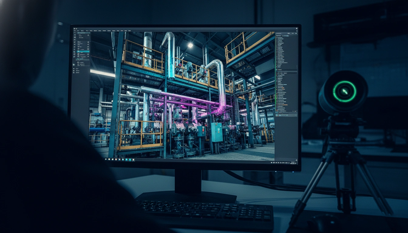
High-density point cloud visualization on a computer screen, showing structural details from a Faro Focus industrial 3D scann

Revolutionizing industrial 3D scanning in Vancouver: applications and value

The specific demands of the industrial sector in British Columbia—encompassing everything from major water treatment facilities to port terminals and refineries—require extreme precision and rapid turnaround. High-accuracy scanning is fundamental to this goal.

Petrochemical, energy, and utility infrastructure

Industrial facilities, characterized by complex piping systems and large machinery, pose immense challenges for traditional measurement. Laser scanning provides the ideal solution for documenting, planning, and maintaining these critical assets.

Typical applications include:

  • As-built documentation: capturing detailed geometric data of piping and entire plants. This is especially useful for older facilities where original CAD data may be lost.
  • Plant retrofitting and expansion: precise data is crucial for planning changes in existing (Brownfield) projects. Scanning facilitates the simulation of new equipment integration and early clash detection.
  • Infrastructure surveying: scanning supports detailed engineering survey in BC projects related to large-scale industrial equipment and electrical substations.
  • Facility management: the creation of an accurate digital twin serves as a long-term record of existing conditions, invaluable for maintenance and remote onboarding of contractors.

Advanced manufacturing and quality control

Beyond infrastructure, industrial scanning is indispensable in manufacturing sectors where dimensional accuracy dictates product quality. For manufacturers in Vancouver, 3D scanning simplifies quality control and accelerates development cycles.

  • Quality control & metrology: scanning allows for precise “as-built” verification against “as-designed” CAD models, revealing deviations via color-coded analysis with precision as high as 0.05 mm.
  • Reverse engineering: when original technical drawings are missing for legacy parts, 3D scanning captures existing geometry to create new CAD models, vital for spare part production.
  • Prototyping and development: scanning rapidly captures prototypes, allowing developers to quickly iterate designs during the product development lifecycle.

Enhancing construction site scanning and BIM workflows

In Vancouver’s robust construction sector, the trend towards digital delivery and Building Information Modeling (BIM) mandates highly reliable reality capture. Construction site scanning is the foundation for virtually all modern BIM-enabled projects.

From point cloud to BIM: the scan-to-BIM mandate

Scan to BIM is the transformative process where raw point cloud data is converted into an intelligent, editable BIM model. This approach is crucial for renovation and repurposing existing property, drastically reducing errors in the design phase.

The process involves collecting data with high-precision scanners, processing the point clouds, and meticulously transforming them into a detailed BIM model compatible with major platforms like Revit. This digital representation delivers an accurate digital twin configuration, supporting asset management throughout the building’s lifecycle.

Mastering MEP clash detection and coordination

A primary benefit of construction site scanning is its utility in managing the complexity of mechanical, electrical, and plumbing (MEP) systems.

  • Proactive conflict identification: MEP Scan to BIM facilitates effective clash detection, allowing project teams to identify design conflicts before physical construction begins.
  • Accurate as-built documentation: detailed spatial data ensures that constructed MEP components align perfectly with the design intent.
  • Coordination between trades: the BIM model serves as a single source of truth, enhancing coordination and communication among different trades.

As-built verification and compliance

For architects and developers operating under local regulations, such as the BC Building Code, compliance is non-negotiable. 3D scanning provides the ultimate tool for verifying the as-built condition against design specifications.

  • Verifiable accuracy: scanning delivers verified as-built drawings essential for future reference.
  • Monitoring progress: scanning can be used to monitor construction progress, comparing the site’s current state with the theoretical model to detect deviations immediately.
  • Heritage preservation: for Vancouver’s heritage properties, non-destructive scanning ensures restoration complies strictly with historical and structural requirements.

Point cloud services Vancouver: the core deliverable

The most immediate output of a high-resolution 3D scan is the point cloud. Accessing high-quality point cloud services Vancouver provides stakeholders with the raw, highly precise spatial data necessary to drive sophisticated digital workflows.

Faro point cloud data processing for industrial and construction projects

Data integrity and software integration

A quality point cloud is achieved through rigorous professional procedures. Professionals utilize specialized software to clean, align, and refine individual clouds, ensuring geometric accuracy.

Once generated, the data integrates seamlessly with industry-standard platforms:

  • CAD platforms: integrate with AutoCAD and Civil 3D for extracting 2D plans and sections.
  • BIM platforms: transform data into editable models within Revit and ArchiCAD.
  • Specialized analysis: enable detailed analyses such as deformation studies and volume calculations.

This foundational data allows engineering survey in BC firms to accelerate workflows and provide reliable measurements for complex infrastructure.

Strategic advantages for Vancouver stakeholders

The technological advancements offered by high-accuracy laser scanning provide distinct competitive advantages across Vancouver’s building sector.

  • For property owners: high-precision scans provide accurate measurements for transactions and simplified planning for renovations. Immersive “digital twins” allow remote stakeholders to visit the site virtually.
  • For architects: scanning provides a reliable design baseline, eliminating reliance on old paper drawings. It ensures seamless integration with design software and faster project turnaround.
  • For contractors: the primary benefits are cost savings and risk reduction. By avoiding costly errors and rework through clash detection, the overall cost of ownership is lowered. High-accuracy scans also support offsite prefabrication, reducing downtime.

Conclusion: the future of accuracy in British Columbia

The era of relying on antiquated tools and imprecise measurements is rapidly fading in Vancouver’s sophisticated construction and industrial sectors. Through the specialized capabilities of advanced terrestrial laser scanners, such as the Faro Focus, stakeholders now have access to reality capture data defined by unparalleled accuracy, speed, and completeness.

The detailed digital twin created through a Faro Focus survey powers mission-critical workflows, including rapid construction site scanning, precise quality control in manufacturing, and mandatory clash detection in industrial retrofits. High-fidelity point cloud services Vancouver provide the essential data format that elevates project certainty and compliance across every discipline. By embracing this level of technological precision, professionals in British Columbia are building better, faster, safer, and more sustainably, securing the foundation for Vancouver’s future infrastructure.

Precision in Practice: Elevating Vancouver Renovations with Leica BLK 360 High‑Definition Surveys

The renovation market in Vancouver, spanning from heritage conversion projects in Kitsilano to high-rise interior modernizations downtown, demands uncompromising precision. In this environment, the margin for error in architectural planning is effectively zero, particularly when navigating strict local zoning bylaws and the rigorous standards set forth by provincial bodies. Consequently, forward-thinking professionals are rapidly adopting modern 3D reality capture solutions. Specifically, the utilization of the Leica BLK 360 series is fundamentally changing how accurate documentation is performed in the region, establishing high-definition 3D scanning in Vancouver as the industry standard for securing seamless, cost-effective, and code-compliant projects.

The Leica BLK 360 is not merely a measuring tool; it is a compact, robust system that captures the physical world with high-resolution 3D panoramic images overlaid onto a high-accuracy point cloud. This process transforms complex, time-consuming manual measurements into a swift, digital, and infinitely reusable data set. The democratization of 3D scanning, pioneered by the BLK 360, makes this professional-grade technology accessible for a wide array of projects, from small residential kitchen remodels to large-scale commercial retrofits.

The imperative for precision in Vancouver renovations

In the architecture, engineering, and construction (AEC) sector, precise data is the foundation of every successful project. For projects involving existing structures—the vast majority of renovation work—the need for accurate "as-built" documentation is paramount. This reality capture approach ensures that architects and designers are working with data that reflects the current, true geometry of the building, rather than outdated or inaccurate blueprints.

Modern high rise interior space in downtown Vancouver being scanned by Leica BLK 360, showing panoramic HDR image overlay and

The limitations of traditional measurement

Traditional surveying methods often involve measuring tape, laser distance measurers (like the Leica DISTO), and manual notation. While these tools are essential, they are inherently prone to human error and data gaps, especially in the complex, cluttered, or multi-faceted environments typical of older Vancouver properties.

Key disadvantages of manual surveying:

  • Time consumption: manually measuring every angle, wall offset, and ceiling height is extremely time-consuming, often requiring multiple site visits to capture missing data.
  • Data interpretation risk: manual data collection is susceptible to individual interpretation, leading to potential inconsistencies when translating measurements into CAD or BIM models.
  • Lack of context: traditional measurements fail to capture the rich, visual context (like textures, colors, and non-structural details) that 3D scanning provides through high-definition panoramic imagery.

The cost of inaccurate or incomplete initial measurements is significantly high, often resulting in expensive rework, construction delays, and material waste—issues that compromise profitability and client satisfaction. Utilizing modern 3D scanning Vancouver techniques is the direct solution to mitigate these risks.

Meeting BC Building Code and safety standards

While the specific details of the BC Building Code fall outside the technical data provided for the scanner itself, professional-grade precision is the means by which all complex regulatory requirements are met. The millimeter accuracy offered by advanced 3D scanners provides the reliable measurement needed to verify structural clearances, confirm adherence to fire separations, and correctly document load-bearing element positions for engineering review.

For structural and mechanical engineers in Vancouver, the data must be irrefutable. The Leica BLK 360, particularly the newer generation, provides 4 mm accuracy at a distance of 10 m. This geometric correctness ensures that the derived models are exact, avoiding the "rounded edges" often produced by lower-grade scanners. This level of precision is indispensable for creating accurate as-built drawings BC mandates for many large renovation or conversion projects, offering clarity and control in critical processes.

Introducing the powerhouse: Leica BLK 360 technology

Leica Geosystems is renowned in the reality capture space for producing high-grade laser scanners. The BLK 360 series, including the award-winning original G1, the second-generation BLK 360 (G2), and the recently introduced SE edition, are leading this technological wave. These devices harness LiDAR technology to capture millions of individual point measurements—a "point cloud"—in a single XYZ coordinate system.

Speed and accuracy: a game changer

The efficiency of a 3D scanning Vancouver operation is determined by the speed of data acquisition and the reliability of the resulting point cloud. The BLK 360 G2 represents a massive leap forward in these aspects compared to its predecessor (G1) and many competing systems.

  • Point measurement rate: Leica BLK 360 G2 captures up to 680,000 pts/sec (nearly 2x faster than the G1).
  • Rapid capture time: The G2 can capture a full scan with spherical images in just 20 seconds (LDR), compared to approx. 2:50 minutes for the G1.
  • Enhanced precision: The G2 offers 4 mm accuracy at 10m, significantly more precise than the 6 mm offered by the G1.
  • VIS technology: The G2 features the Visual Inertial System (VIS) for automated pre-registration, a feature absent in the G1.

This incredible speed allows users performing an architectural survey Vancouver to complete large job sites much faster. Teams can rapidly move from setup to setup, ensuring minimal interruption to the site or tenants. Furthermore, the G2 utilizes a 4-camera system with 13 megapixels each, capturing 5-bracket HDR spherical images. This high dynamic range imaging is crucial for difficult lighting conditions—such as bright Vancouver sunlight streaming through large windows combined with dark interior shadows.

Portability and ease of use

The BLK 360 is built for mobility, a critical factor for professionals moving frequently between diverse sites across the Lower Mainland.

The second-generation BLK 360 design features:

  • Compact form factor: measuring just 155 mm in height and 80 mm in diameter.
  • Lightweight build: weighing only 0.75 kg (0.85 kg including the battery), a 20% reduction compared to the original.
  • One-button operation: designed to be operated autonomously with a single button, making scanning straightforward and accessible.

This portability allows the scanner to be easily transported and set up in tight spaces, such as crowded mechanical rooms or small residential bathrooms—common constraints in Vancouver renovation projects.

Portable Leica BLK 360 scanner setup in a tight interior space

Leica BLK 360 scanner positioned on a tripod in a tight mechanical room, illustrating its compact size and portability for re

The workflow of modern 3D scanning Vancouver

A critical advantage of utilizing Leica BLK 360 services is the seamless digital workflow, spanning from quick field capture to instant data registration and final export into industry-standard design software.

Field capture with the Leica BLK 360

The scanning process is controlled intuitively via mobile applications, ensuring real-time feedback and quality control directly on site. The scanner can be controlled either autonomously or remotely via a connected mobile device using apps like Leica Cyclone FIELD 360.

The capture process:

  1. 1. Setup: The scanner is mounted on a tripod or placed on a flat surface.
  2. 2. Connection: The device broadcasts its own Wi-Fi signal for real-time data transfer to a smartphone or tablet.
  3. 3. Resolution selection: Users choose preset resolutions (e.g., 6/12/25/50 mm @ 10 m) based on the detail required for the interior laser scanning task.

Real-time registration with VIS technology

For professional firms providing architectural survey Vancouver services, the Visual Inertial System (VIS) in the G2 model is a game changer.

  • VIS explained: It combines video-enhanced inertial measurement units (IMU) and camera tracking to monitor the scanner's movement.
  • Automated alignment: The system tracks where the scanner is located at all times. Each subsequent scan is automatically aligned with the previous one while the operator is still on site.
  • Efficiency: This automation means that 95-97% of scan positions are correctly merged immediately, significantly reducing post-processing time.

Post-processing and deliverables

Once field work is complete, data is transferred via Wi-Fi or USB-C to desktop software like Leica Cyclone REGISTER 360 for final cleaning and verification. The final data is exported in formats essential for collaboration in the AEC industry:

  • E57: A universal, non-proprietary point cloud format.
  • RCP/RCS: Autodesk's native formats for integration into AutoCAD and Revit.
  • LGS: Leica's proprietary lightweight format containing all data and photos.

The finalized model is used to generate high-quality as-built drawings BC firms rely on, including detailed 2D floor plans, 3D BIM models, and digital twins.

Scan-to-BIM point cloud workflow for Vancouver architecture and renovation projects

High resolution point cloud and HDR spherical imagery captured with Leica BLK 360 being integrated into a BIM model on a comp

Specialized applications for architectural survey Vancouver needs

The versatility and high-definition output of the Leica BLK 360 make it applicable far beyond simple surveys. Its application spans the entire construction lifecycle.

Interior laser scanning: capturing complex spaces

Interior laser scanning presents unique challenges in renovation projects, often involving irregular walls, tight spaces, and complex piping. The BLK 360 is perfectly suited for these environments.

For instance, when documenting conditions for kitchen or bathroom remodeling in Vancouver homes, the BLK 360 captures intricate geometries with the necessary millimeter precision. This detail is critical for bespoke elements such as custom cabinetry, countertop fabrication, and complex HVAC installations.

Vancouver home renovation documented with a precise 3D laser scan

Applications beyond as-built documentation

  • Building Information Modeling (BIM): The dense point cloud enables "Scan to BIM," allowing for immediate clash detection and constructability reviews.
  • Historical preservation: The BLK 360 creates precise digital models of heritage sites, ensuring complex architecture is documented for restoration.
  • Virtual Reality (VR): HDR spherical imagery combined with point clouds allows for immersive client presentations and real estate marketing.
  • Progress monitoring: Periodic scanning allows construction managers to monitor progress against the design model, ensuring accuracy and schedule adherence.

Choosing the right Leica BLK 360 model

Leica Geosystems offers highly capable variants in the BLK 360 line. Choosing the right one depends on project size, desired speed, and budget.

BLK 360 G2: the high-end standard for AEC

The G2 model is the definitive choice for high-volume, time-critical, or complex projects.

  • Maximized productivity: The 680,000 pts/sec capture rate and VIS system ensure maximum efficiency.
  • Large projects: Ideally suited for multi-story buildings or large industrial areas where registration time must be minimized.
  • Fastest transfer: Features enhanced Wi-Fi and USB-C 3.0.

BLK 360 SE: precision meets affordability

The SE (Standard Edition) is designed for optimal price-performance for small-to-mid-sized projects.

  • Speed: Captures 340,000 pts/sec (roughly half the speed of the G2).
  • No VIS technology: Registration must be done manually or in office software.
  • Target audience: Ideal for smaller architecture studios or specialized trade contractors (e.g., millworkers) where cost-efficiency outweighs the need for maximum speed.

Conclusion: securing success through advanced reality capture

The rapid adoption of high-precision 3D scanning in Vancouver reflects a clear shift toward digital, data-driven methodology. For the demanding and competitive renovation market, the Leica BLK 360—especially the powerful G2 model—provides the essential tools for success.

Firms that embrace Leica BLK 360 services are investing in reliability, efficiency, and safety. By replacing error-prone manual methods with rapid, millimeter-accurate scanning, architects, interior designers, and contractors can ensure their as-built drawings BC are flawless. This technology transforms the complex task of capturing reality into a simple operation, establishing a solid digital foundation that allows professionals to build with confidence.

3D Scanning Vancouver: As-Built Measurement Methods

In the dynamic world of architecture, engineering, and construction (AEC), precision is not merely a preference; it is the absolute foundation of success. For property owners planning a significant overhaul or professionals executing a complex commercial retrofit, understanding the current state of a building—its “as-built” condition—is the critical first step. While traditional methods remain foundational, modern reality capture, especially 3d scanning Vancouver, has transformed how we approach accurate floor plans and large-scale home renovation Greater Vancouver projects. Leveraging advanced technology like 3D laser scanners ensures that every dimension, fixture, and structural element is documented with unparalleled accuracy, providing a solid, data-driven starting point for design and renovation planning.

The imperative of precision: why as-built documentation matters

As-built documentation, often referred to as record drawings, is documents that reflect the actual and current condition of a space or building at the time of measurement. These documents are indispensable because they record any deviations or changes made from the original architect’s design, accounting for years of tenant improvements or on-site construction modifications.

Defining “as-built”: beyond blueprints

When a building is completed, the original design blueprints often cease to be a true reflection of reality. Walls may have moved, systems may have been upgraded, and configurations changed. Accurate floor plans and comprehensive as-built records serve as the definitive shared knowledge resource, critical for everything from routine maintenance to major redevelopment.

Key elements captured in high-quality as-built documentation include:

  • size, location, and dimension: precise measurements of spaces and elements.
  • architectural features: walls, door locations, ceiling heights, and intricate details.
  • MEP systems: locations of mechanical, electrical, and plumbing fixtures and systems.
  • structural elements: load-bearing walls and complex structural features.

The cost of imprecision in renovation planning

Inaccurate or outdated documentation is a leading cause of delays, costly errors, and change orders in construction projects. For a significant Greater Vancouver home renovation, starting without precise measurements means risking major clashes—such as discovering a new piping system interferes with existing ventilation—which can waste significant time, frustration, and money.

Whether for commercial or residential projects, reliable data supports better renovation planning and helps project teams identify potential conflicts and errors early in the project lifecycle, facilitating timely adjustments. Investing in meticulous as-built measurement upfront minimizes future risks and provides the clarity and confidence needed for seamless execution.

Regulatory compliance and building permit drawings

In British Columbia, adherence to the BC Building Code and municipal guidelines is non-negotiable for most construction and home renovation Greater Vancouver projects. Accurate floor plans are crucial for securing the necessary building permit drawings.

As-built surveys provide documentation required for:

  • certification of occupancy: following new construction, an as-built survey provides homeowners with a certification of occupancy.
  • municipal compliance: documentation ensures the structure adheres to local regulations and municipal guidelines.
  • detailed submissions: as-built drawings are effective starting points for creating building permit drawings, design, construction drawings, and remodeling plans, which require fresh, up-to-date, and precise measurements.

The legacy methods: from tape measure to theodolite

The evolution of as-built measurement spans decades, moving from purely manual efforts to highly digitized processes. While modern technology dominates, understanding the foundation of these techniques is essential.

Manual measurement and handheld lasers (the foundation)

Traditional measuring techniques are the historical backbone of as-built documentation. These methods rely on physical measurements taken by skilled professionals:

  • tape measures and rulers: time-tested tools, highly dependable for smaller areas, but requiring significant effort and time for complex or large structures.
  • laser distance meters: these handheld devices represent a significant efficiency step up, providing digital distance measurements.

In some workflows, like the classic “ninja” method, surveyors measure and draft on-site using handheld laser distance meters wirelessly tethered to portable CAD workstations. Even modern, high-tech processes often combine reality capture with verified manual measurements for specific features like doors, windows, and ceiling heights to ensure completeness. However, for expansive spaces, relying solely on manual methods risks missing intricate details and sacrificing efficiency compared to modern 3d scanning Vancouver techniques.

Total station surveying: when ground precision is paramount

Total station surveying is a highly specialized method that integrates theodolite (angle measurement) capabilities with electronic distance measurement (EDM).

  • application: it is frequently used in land surveying to accurately measure angles and distances for precise mapping and capturing topographic data.
  • precision: it delivers accurate results, making it highly valuable for exterior site plans and infrastructure projects.

While Total Stations offer superb accuracy, they generally require significant setup and time when used for detailed internal construction documentation or architectural measurement, especially compared to the rapid data collection capabilities of 3D laser scanning services.

The digital revolution: advanced 3d scanning Vancouver technologies

The current industry standard for capturing complex existing conditions has overwhelmingly shifted toward digital reality capture technologies, led by LiDAR and 3D laser scanning. These methods offer ground-level accuracy—sometimes down to the millimeter—while drastically reducing the time and cost associated with field work.

LiDAR scanning: unmatched accuracy and speed

LiDAR (Light Detection and Ranging) scanning is a leading-edge technology that revolutionizes how specialists capture and document existing spaces. In the context of 3d scanning Vancouver, this technology is quickly becoming mandatory for numerous industries, enhancing project accuracy and optimizing renovation planning.

Advantages of LiDAR and 3D laser scanning:

  • precision beyond measure: laser scanning captures millions of measurement points in seconds, creating a high-resolution, detailed 3D representation of the environment. This process ensures intricate details and complex geometrical features are captured precisely.
  • time efficiency: for large and complex projects, the speed of data accumulation saves considerable time compared to traditional methods.
  • comprehensive data: the resulting point cloud data maps every surface and feature of the space, including the structure, pipes, and wires.
  • enhanced safety: experts can collect data safely from a distance, minimizing the need for physical measurements in potentially hazardous or difficult-to-access areas.

The raw output of this technology is detailed point cloud data, which is essential for creating both 2D and 3D as-built documentation. This data forms the reliable foundation for your next project, minimizing errors and streamlining the design process.

3D laser scanning in Vancouver capturing accurate existing building conditions

Photogrammetry and reality capture

Photogrammetry is another reality capture method that involves using high-resolution photographs to create 3D models. Software algorithms analyze multiple images to determine object positions and construct a digital model.

  • method: this technique relies on the quality and overlap of the pictures taken.
  • application: it is often used for creating 3D assets for visual effects in film and media, as well as documenting heritage sites.

While versatile, photogrammetry may not achieve the same level of geometric accuracy and precision required for critical construction documentation in engineering or complex home renovation Greater Vancouver projects, especially compared to advanced laser scanning.

Choosing the right accuracy level for 3d scanning Vancouver

Different projects demand different levels of tolerance. A luxury interior fit-out requires a higher degree of accuracy than a rough industrial site plan. Reputable 3D laser scanning services offer various tolerance requirements, ranging from approximately 1mm accuracy to 10mm accuracy, ensuring the right scanner is deployed for the specific needs of your project.

For interior designers and contractors in Vancouver, the high precision afforded by commercial-grade LiDAR technology is crucial for ensuring that custom cabinetry, mechanical systems, and structural modifications align perfectly, providing peace of mind from the initial scan to the final model delivery.

Transforming data into actionable models: scan to BIM/CAD workflows

The point cloud: the foundation of digital data

The starting point for converting scan data into useful construction documentation is the point cloud. This dense collection of millions of measurement points accurately maps every surface of the space.

The process follows these critical stages:

  • collection: sophisticated 3D laser scanning technology captures accurate measurements and high-quality point cloud data of physical buildings and spaces.
  • data processing: the raw scan data is meticulously cleaned and refined, removing noise and irrelevant elements. This refined data ensures the final models reflect existing conditions with precise measurements.
  • conversion: experts transform the processed point cloud into detailed, editable BIM models or CAD drawings using specialized software.
Scan-to-BIM modeling workflow converting point cloud data into a Vancouver building model

Scan to BIM: the interior designer tools and contractor advantage

Scan to BIM is a transformative process central to modern 3d scanning Vancouver services. A BIM model is a comprehensive digital representation of a building’s physical and functional characteristics.

For design and construction professionals, BIM models are invaluable interior designer tools because they:

  • integrate seamlessly: models are compatible with major software platforms, ensuring easy incorporation into ongoing design and construction workflows.
  • facilitate collaboration: BIM serves as a shared knowledge resource, ensuring all stakeholders (architects, engineers, contractors, interior designer tools) have access to accurate, up-to-date information.
  • enable clash detection: detailed models allow project teams to identify potential clashes and costly errors early in the planning phase, such as conflicts between structural and electrical elements.
  • detailing and metadata: models are enhanced with dimensions, specifications, and metadata, preparing them for use in the construction phase or facility management.

For contractors and interior designer tools, the ability to move directly from a point cloud to an intelligent, editable Revit 3D model, accurately reflecting site conditions, saves immense time and allows design teams to focus purely on design and execution.

Interior designer using BIM tools and scan-based building documentation in Vancouver

Delivering accurate floor plans and construction documentation

Whether the final deliverable is a high-resolution 3D model or precise 2D drawings, the result is robust construction documentation. Services offered by experts like MeasureBuilt include a tailored suite of files necessary for any project:

  • 2D as-built floor plans and elevations: capturing precise dimensions and conditions of existing spaces in formats like PDF and DWG.
  • BIM models: intelligent 3D models (e.g., Revit .RVT files) that capture every architectural and structural element.
  • point cloud data: the raw, high-resolution 3D scan data (.rcp, .E57 files) for direct use by engineering teams.
  • custom measurements: including site plans, cross-sections, and reflected ceiling plans.

This comprehensive approach ensures that whether you are performing a complex Greater Vancouver home renovation or developing a large commercial property, your project is founded on verified, current data.

Specialized deliverables for the Greater Vancouver market

The diverse real estate and construction landscape in Greater Vancouver demands specialized documentation tailored to the needs of homeowners, real estate agents, contractors, and building managers. 3d scanning Vancouver providers are equipped to deliver solutions that meet these distinct demands.

Real estate floor plans and virtual walkthroughs

For real estate agents and property owners in Vancouver, compelling marketing materials are essential in a competitive market. 3D laser scanning services and accompanying technologies have redefined property listings.

  • MLS real estate floor plans: these professional, visually appealing plans, often available in 2D and 3D formats, help potential buyers visualize the space accurately and make listings more engaging. Accurate measurements, compliant with BOMA standards when needed, validate the value of a property and assist in investment sales.
  • virtual walkthroughs: immersive 360° virtual tours (such as Matterport or iGuide) allow remote stakeholders or potential buyers to navigate a property easily. These tours capture precise as-built details, serving not only as powerful marketing tools but also as crucial documentation for design teams. 3D scanning Vancouver firms emphasize these deliverables, recognizing their value for market appeal.

Supporting contractor estimates and project management

Contractors specializing in residential or commercial home renovation Greater Vancouver projects rely heavily on precision to develop accurate budgets and schedules.

  • precise planning: detailed and reliable as-built drawings ensure every project starts correctly, making planning and execution seamless.
  • contractor estimates: using precise measurements instead of approximations prevents costly mistakes and ensures that contractor estimates are accurate, reflecting the actual scope of work required.
  • progress monitoring: for large commercial builds, 3D laser scanning services can be used for construction progress monitoring, providing regular, detailed updates and reports crucial for management and decision-making, helping to track quantities and material usage.

Ensuring BOMA compliance for commercial assets

Building owners and facility managers require thorough and accurate accounting of building areas, particularly for leasing purposes. The BC Building Code and industry standards govern these requirements.

  • BOMA floor area analysis: professionals deliver comprehensive floor area surveys compliant with the most current BOMA (Building Owners and Managers Association) floor measurement standards. This ensures that all leasable space is correctly accounted for and allocated.
  • facility management: for ongoing operations, accurate, up-to-date drawings are the “road map” for maintenance, retrofitting, and updating systems. 3D scanning Vancouver services simplify drawing management by providing models that are accurate, searchable, up-to-date, and usable for the operations team.

3d scanning Vancouver in specialized contexts

The utility of advanced measurement extends far beyond standard commercial construction, touching diverse sectors across the region.

Heritage preservation and adaptive reuse

Vancouver and British Columbia are home to numerous heritage sites that require detailed documentation and conservation. 3D laser scanning services are essential here:

  • non-invasive documentation: non-invasive 3D capture technology is utilized to preserve historical landmarks, churches, and heritage properties.
  • detailed documentation: laser scanners capture every intricate detail, providing precise point cloud data for restoration and adaptive reuse projects. This approach is the most sustainable way of restoring heritage structures.
LiDAR scanning a historic Vancouver building for heritage documentation

Coordination and quality assurance (QA/QC)

In complex engineering and construction projects, verifying the “as-built” reality against the initial design intent is crucial for quality assurance.

  • clash verification: using 3D scanning to check whether two piping systems or different structural elements will clash in a given space can save untold time and money.
  • condition verification: advanced QA/QC involves verifying the condition of materials and parts. The precision of 3d scanning Vancouver technologies, capable of capturing data down to the millimeter, supports high design and construction quality works.

The role of software: interior designer tools and drafting

While the scanner captures the data, the specialized software turns it into a functional asset. Modern workflows rely heavily on platforms like AutoCAD and BIM solutions.

  • CAD drafting: AutoCAD remains an industry standard for drafting, allowing specialists to create precise, detailed drawings essential for construction documentation and ensuring unique measurements are properly represented.
  • intelligent BIM: leading 3D laser scanning services utilize BIM solutions to create models that integrate seamlessly with design software. These intelligent models are crucial interior designer tools because they allow for precise visualization and modification of the space.

The future of measurement: embracing 3d scanning Vancouver

The move from manual measurement to digital reality capture is an irreversible shift driven by the economic, safety, and accuracy benefits provided by modern 3D laser scanning services.

Efficiency and safety gains

The traditional approach to measuring a large building could take days or weeks of manual labor. Utilizing 3d scanning Vancouver technology significantly optimizes the process:

  • quick turnaround: the process is optimized for time-sensitive projects, providing quick delivery of data and models without compromising quality. Some providers even offer virtual tours and accurate floor plans within 48 hours.
  • reduced rework: by minimizing measurement errors, clients experience less rework and smoother planning, contributing to possible on-time project deadlines.
  • sustainability: enhanced accuracy improves resource use and reduces material waste, supporting sustainable construction techniques.

Furthermore, by reducing the need for ground personnel in complex or dangerous areas, 3D scanning minimizes site dangers, contributing significantly to project safety.

Finding reliable 3D laser scanning services

For homeowners, interior designers, contractors, and real estate agents, choosing a reliable partner for 3D laser scanning services is paramount to project success. When evaluating providers in the home renovation Greater Vancouver area, look for:

  • advanced technology: firms should employ state-of-the-art 3D scanning tools and leading BIM/CAD software to capture intricate details precisely.
  • expertise in BIM/CAD: skilled specialists who are proficient in converting complex point cloud data into accurate, editable models ready for architectural or construction documentation.
  • customized deliverables: services should be tailored to specific architectural or commercial requirements, whether you need accurate floor plans, full BIM models, or only real estate floor plans and virtual tours.
  • local experience: providers serving the Metro Vancouver area, including Richmond, Surrey, Burnaby, and Coquitlam, often have local expertise essential for understanding municipal requirements for building permit drawings.

Conclusion: the foundation of confidence

From the rudimentary tape measure to the transformative power of 3d scanning Vancouver, the tools available for generating as-built measurements have evolved dramatically. For any professional undertaking renovation planning—whether an interior designer tools specialist refining a residential layout or a contractor seeking precise data for contractor estimates—high-precision documentation is the key to minimizing risk and achieving efficiency.

By utilizing advanced 3D laser scanning services, professionals in Greater Vancouver home renovation can secure highly accurate floor plans and comprehensive construction documentation. This digital foundation is essential for producing reliable building permit drawings and marketable real estate floor plans, ensuring that every project, from small condos to large commercial facilities, starts and finishes with confidence and accuracy. When embarking on your next project, remember the motto: “Measure Once, Build for a Lifetime”.

Book Measurements Get a Quote