Scan to BIM Vancouver: Revit Models from Scans
Scan to BIM Vancouver services convert measured building conditions into accurate Revit models using 3D laser scanning, point cloud processing, and structured BIM modelling. This workflow helps architects, engineers, contractors, and property…
Quick Answer
Scan to BIM Vancouver services convert measured building conditions into accurate Revit models using 3D laser scanning, point cloud processing, and structured BIM modelling. This workflow helps architects, engineers, contractors, and property owners document existing conditions before renovation, retrofit, tenant improvement, or facility planning. The main value is a reliable digital model that supports design coordination, clearer documentation, and fewer measurement-based assumptions.
Executive Summary
Scan to BIM in Vancouver is the process of capturing an existing building with 3D laser scanning, registering the scan data into a point cloud, and modelling the verified conditions in Revit or another BIM platform. The process is especially useful when older drawings are missing, inaccurate, incomplete, or not detailed enough for renovation planning. In Greater Vancouver, scan to BIM can support residential renovations, commercial tenant improvements, industrial facility upgrades, heritage documentation, and complex building coordination. A Revit model from laser scan data can help project teams understand existing walls, columns, levels, openings, ceiling conditions, structural relationships, and visible building systems. The practical takeaway is that scan to BIM should be scoped carefully: the required model detail, file formats, point cloud access, quality checks, and final deliverables should be defined before site scanning begins.
Scan to BIM in Vancouver: From 3D Laser Scanning to Accurate Revit Models
What Scan to BIM Vancouver Means for Existing Building Documentation
Scan to BIM Vancouver refers to the workflow of converting measured site conditions into a usable building information model. A measurement team first captures the building with 3D laser scanning, then processes the scan data into a registered point cloud, and finally creates a BIM model that represents the existing conditions. For architects, engineers, contractors, and property owners in Vancouver, scan to BIM provides a stronger starting point than outdated drawings or manual measurements alone. The practical rule is to use scan to BIM when design decisions require reliable digital documentation of the existing building.
A Revit model from laser scan data is not automatically created by the scanner. The scanner captures visible geometry, but trained BIM modellers still need to interpret the point cloud, define building elements, create model components, and verify the model against the scan data. This distinction matters because the quality of the final BIM documentation depends on both field capture and modelling decisions. Project teams should treat scan to BIM as a professional documentation workflow, not as a one-click software output.
Point cloud to BIM Vancouver services are most valuable when existing conditions affect design coordination. Older homes, commercial buildings, industrial facilities, strata properties, and tenant improvement spaces may not match historical drawings. A scan-based BIM model helps the design team understand what currently exists before preparing proposed work. The practical takeaway is to document the current building before modelling the future building.
When Scan to BIM Is Better Than Basic Floor Plans or Scan-to-CAD
Scan to BIM is better than basic floor plans when the project requires three-dimensional coordination. A simple floor plan can show walls, doors, room sizes, and general layout, but it may not fully explain ceiling heights, level changes, structural relationships, roof geometry, or complex building systems. Scan to BIM can model existing conditions in 3D so the project team can understand vertical and spatial relationships more clearly. The decision rule is to choose BIM when 2D documentation does not provide enough coordination value.
Scan-to-CAD is often enough when the project only needs accurate 2D drawings. Many residential renovations, small commercial layouts, and permit-support drawing packages can work well with CAD floor plans, elevations, and sections. Scan-to-BIM may be a better fit when the architect or engineer works in Revit, the building has complex geometry, or the project involves multiple disciplines. Property owners should ask the design team whether they need DWG drawings, a Revit model, a point cloud, or a combination of deliverables.
Scan to BIM is especially useful for complex existing buildings. Heritage properties, older commercial buildings, multi-level facilities, industrial spaces, and buildings with dense visible services may require more than basic measurement. A Revit model from laser scan data can help document relationships between walls, beams, columns, openings, levels, and visible systems. The practical takeaway is to choose scan to BIM when the cost of misunderstanding existing conditions is high.
The Scan to BIM Process: From Site Capture to Revit Model
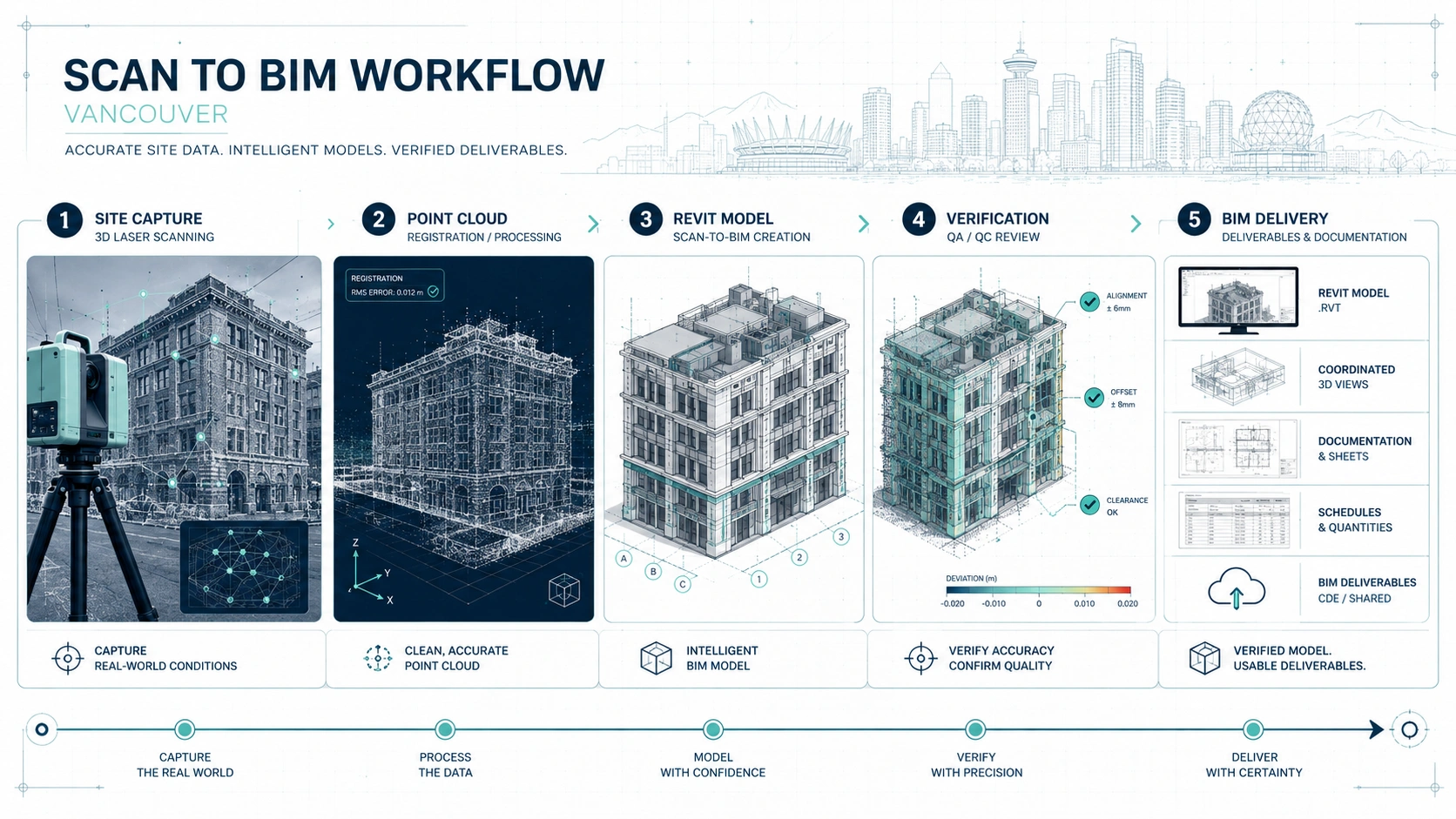
The scan to BIM process starts with scope definition. Before any 3D laser scanning begins, the project team should define which spaces must be captured, what level of detail is required, which building elements should be modelled, and what deliverables are needed. A residential renovation may need walls, windows, stairs, rooflines, and levels, while an industrial project may need columns, dock areas, mezzanines, visible services, and equipment zones. Clear scope definition prevents over-modelling and under-documentation.
The second step is 3D laser scanning on site. The scanner captures visible surfaces from multiple positions and records spatial data as a point cloud. Because laser scanning depends on line of sight, the quality of the capture depends on site access, visibility, and the scanning plan. Locked rooms, blocked walls, stored materials, moving people, or inaccessible ceiling areas can create gaps in the scan. Project teams should prepare the site so the scan captures the conditions that matter.
The third step is point cloud registration and processing. Individual scan positions are aligned into a unified point cloud so the building can be reviewed as one coordinated dataset. The point cloud may then be cleaned, indexed, exported, or prepared for use in modelling software. This step is important because a poorly registered point cloud can affect the reliability of the model. A professional scan to BIM workflow should include point cloud quality checks before Revit modelling begins.
The fourth step is BIM modelling in Revit or another BIM platform. BIM technicians use the point cloud as a reference to create model elements such as walls, floors, roofs, columns, beams, doors, windows, stairs, and visible building systems depending on the scope. The goal is not to model every visible object by default, but to model the elements that support the project’s design, coordination, or documentation needs. Project teams should define model scope before modelling starts.
The fifth step is model verification. The finished Revit model should be checked against the point cloud to confirm that the model represents the agreed existing conditions. This does not mean every surface is modelled perfectly or that hidden conditions are known. It means the model has been reviewed against the captured data and the agreed deliverable scope. The practical takeaway is to ask how the scan to BIM provider verifies model accuracy before delivery.
Why Point Cloud to BIM Vancouver Workflows Need Clear Scope
Point cloud to BIM Vancouver workflows need clear scope because a point cloud contains more information than every project needs. A scan can capture many visible surfaces, but the BIM model should only include the elements required for the project. Modelling unnecessary detail increases cost and time without always improving decision-making. The practical rule is to model for use, not for appearance.
A clear scope should define the level of detail for each building element. A wall may be modelled as a simple vertical element for planning, or it may require more detailed thickness, openings, materials, and relationships depending on the project. A ceiling may be represented only by height information, or the model may need visible beams, soffits, ducts, and equipment. The right level of detail depends on how the Revit model will be used.
A clear scope should also define exclusions. 3D laser scanning captures visible conditions; it does not see through walls, floors, or ceilings. Hidden pipes, concealed structure, underground services, and internal wall assemblies cannot be confirmed unless they are visible, exposed, documented by other sources, or verified by specialists. A trustworthy scan to BIM provider should clearly state what the model includes and what it does not include.
How 3D Laser Scanning Creates the Point Cloud Base
3D laser scanning creates the point cloud base by capturing millions of measured points from visible building surfaces. These points form a digital spatial record that can be viewed, measured, and used as a reference for drafting or modelling. For Vancouver renovation and retrofit projects, this point cloud helps replace guesswork with captured existing-condition data. The practical benefit is that the design team can work from a measured reference instead of relying only on old drawings.
3D laser scanning is useful because it can capture complex geometry more consistently than manual measurement alone. Older buildings may have out-of-square rooms, sloped floors, uneven ceilings, irregular stairs, or non-standard additions. Commercial and industrial buildings may have high ceilings, exposed structure, mezzanines, loading areas, and visible services. A point cloud helps document these conditions more comprehensively than a small set of hand measurements.
3D laser scanning still requires planning and interpretation. The scanner only captures what it can see from its scan positions, so blocked areas and hidden conditions remain limitations. Moving objects, clutter, reflective surfaces, and access restrictions can affect data quality. The practical takeaway is that a strong scanning plan and good site preparation are part of the final BIM model quality.
How a Revit Model from Laser Scan Data Is Created
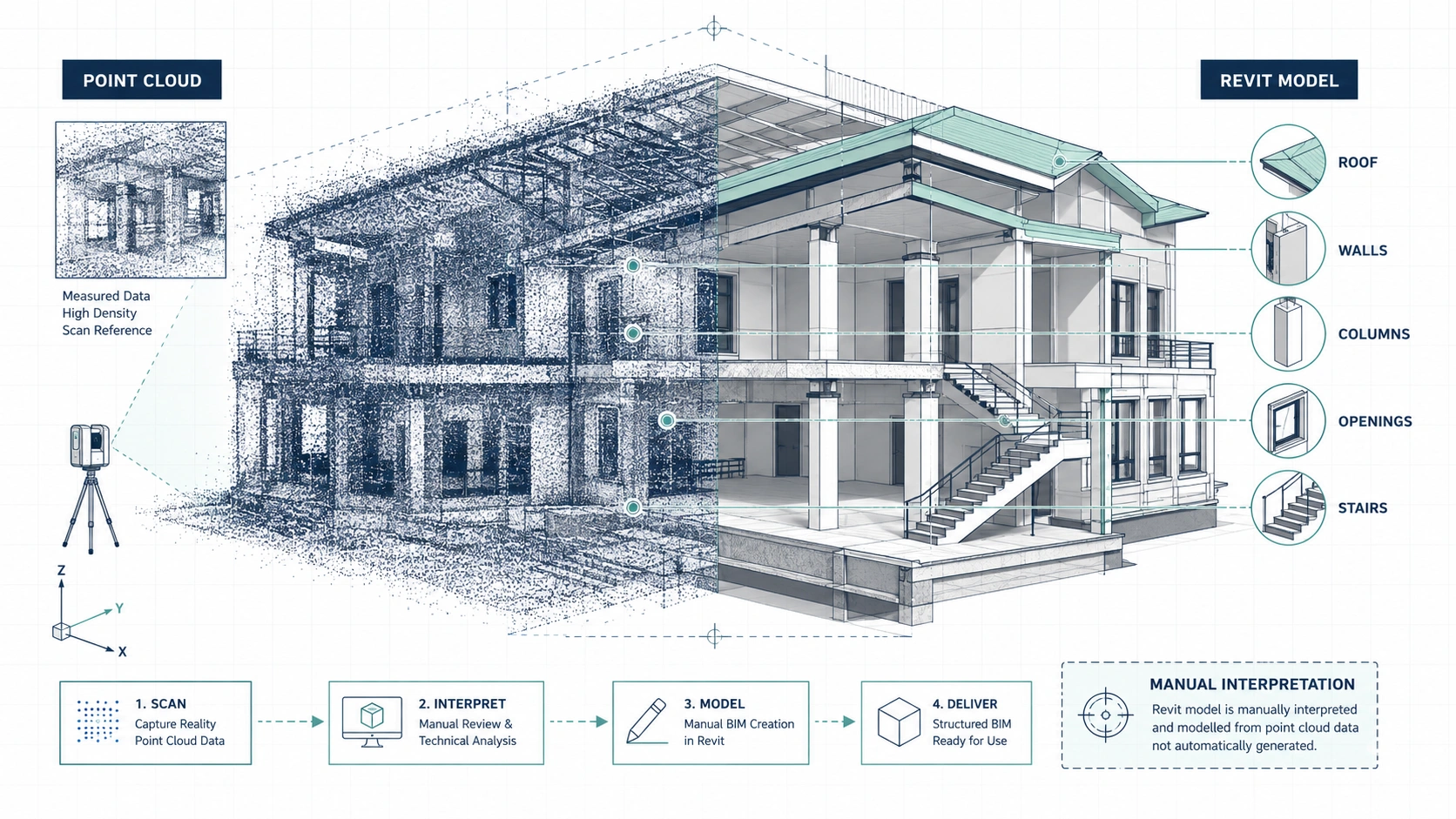
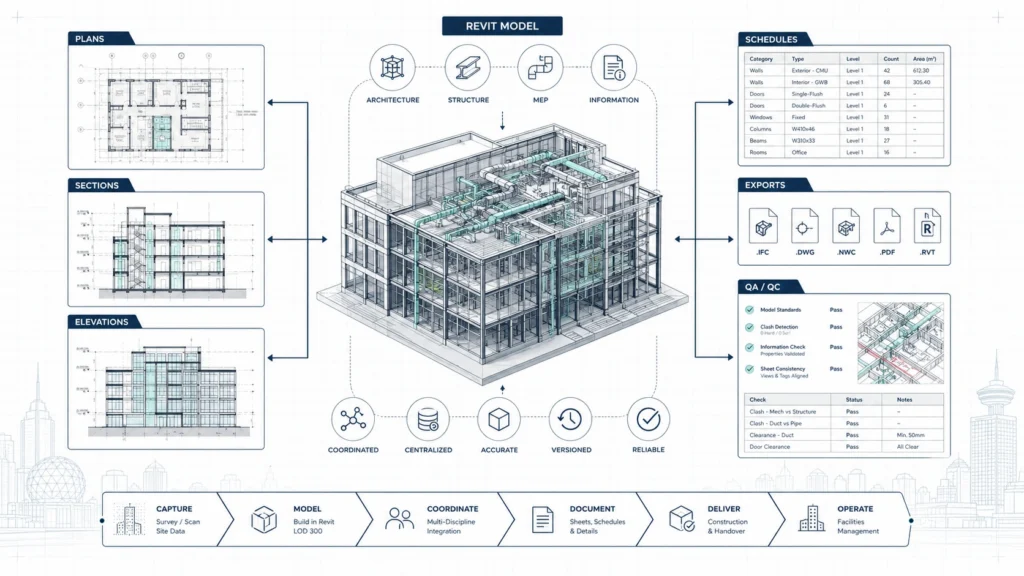
A Revit model from laser scan data is created by using the point cloud as a measured reference. BIM technicians import or link the point cloud into the modelling environment and create building elements that align with the captured conditions. Walls, floors, columns, beams, stairs, openings, roofs, and visible systems can be modelled depending on the required scope. The practical value is that the design team receives a model that represents the existing building in a usable BIM format.
A Revit model from laser scan data requires modelling judgment. Existing buildings are rarely perfectly straight, level, or square, so the modeller must decide how to represent irregular conditions. Some projects need simplified, design-ready geometry, while others need closer representation of unusual or irregular features. These decisions should be discussed before modelling begins. Project teams should ask how the provider handles irregular geometry and tolerances.
A Revit model from laser scan data should be created for the intended workflow. An architect may need walls, levels, roofs, and openings for renovation design. An engineer may need structural elements and sections. A facility team may need spaces, room names, and asset-related organization. A contractor may need model information for coordination and clash review. The best scan to BIM deliverable is the one that supports the next professional decision.
Accuracy, Tolerance, and Model Reliability in Scan to BIM
Scan to BIM accuracy depends on field capture quality, point cloud registration, modelling scope, and verification. A laser scanner can capture detailed spatial data, but the final model is still an interpreted representation of the building. Accuracy should be discussed in practical terms: what elements must align closely with the point cloud, what tolerance is acceptable, and which parts of the building are outside scope. Project teams should ask for a defined accuracy and quality control approach.
Tolerance matters because not every project needs the same modelling precision. A conceptual renovation model may not need the same detail as a model used for prefabrication, complex MEP coordination, or structural retrofit planning. Higher detail can be valuable, but higher detail also increases modelling time and cost. The practical recommendation is to match tolerance and level of detail to the project risk.
Model reliability also depends on what was visible during the scan. Scan to BIM documentation can represent visible existing conditions, but hidden conditions still require other verification methods. Walls may contain concealed structure, pipes, wires, or assemblies that the scanner cannot detect. A responsible BIM documentation provider should avoid implying that a scan-based model confirms hidden conditions. The practical takeaway is to use scan to BIM as a strong existing-condition base, not as a substitute for destructive investigation or specialist review when hidden elements matter.
Scan-to-CAD vs Scan-to-BIM vs Standard Floor Plans
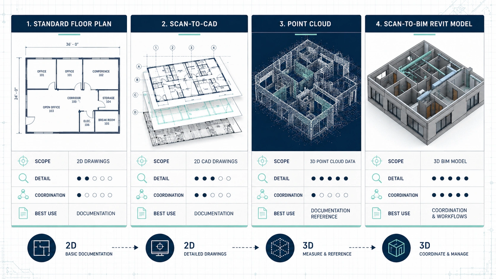
Scan-to-CAD, scan-to-BIM, and standard floor plans serve different project needs. Standard floor plans are useful for general layout understanding, real estate presentation, or early planning. Scan-to-CAD converts measured site data into 2D drawings such as floor plans, elevations, and sections. Scan-to-BIM converts measured site data into a 3D model that can support more advanced design coordination. Project teams should choose the format based on how the documentation will be used.
| Documentation type | Best use | Typical deliverables | Main limitation |
|---|---|---|---|
| Standard floor plans | Basic review, real estate, simple planning | PDF plans, area summaries | Not always detailed enough for renovation or coordination |
| Scan-to-CAD | Design drawings, permit-support documentation, contractor pricing | DWG, PDF, elevations, sections | 2D drawings may not fully support complex spatial coordination |
| Scan-to-BIM | Complex renovation, model-based design, coordination, facility documentation | Revit model, IFC, point cloud, model views | Requires clear scope and more modelling time |
| Point cloud only | Technical reference, future modelling, site verification | E57, RCP, RCS, LAS, or similar formats | Not as usable for non-technical stakeholders without modelling |
Scan-to-CAD is often the right choice when the design team mainly needs accurate 2D documentation. A homeowner, designer, or architect may need CAD floor plans and elevations to develop a renovation concept or prepare drawing sets. Scan-to-BIM becomes more useful when the project involves 3D coordination, Revit-based design, or complex existing conditions. The practical rule is to choose BIM when the model will be actively used, not simply because it sounds more advanced.
Standard floor plans should not be treated as a replacement for BIM documentation. A real estate-style plan may show general room layout, but it usually does not provide the modelling depth needed for architectural coordination. If the project requires a Revit model from laser scan data, the scope should include BIM modelling from the start. Property owners should confirm file formats and use cases before ordering documentation.
Deliverables to Expect from BIM Documentation Vancouver Services
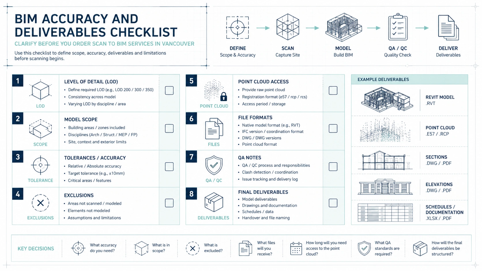
BIM documentation Vancouver services should clearly define final deliverables before fieldwork begins. A complete package may include a registered point cloud, a Revit model, PDF views, CAD exports, floor plans, elevations, sections, roof plans, reflected ceiling information, or model coordination files. Not every project needs every deliverable. The practical recommendation is to request only the files that the project team will actually use.
| Deliverable | What it provides | Who usually uses it | Buyer question |
|---|---|---|---|
| Registered point cloud | Measured spatial reference from scanning | BIM team, architects, engineers, survey teams | Will the point cloud be delivered or only used internally? |
| Revit model | Modelled existing building elements | Architects, engineers, BIM teams | What elements and level of detail are included? |
| PDF drawing set | Readable plans, elevations, sections, or views | Owners, contractors, managers, consultants | Which views are included in the package? |
| DWG export | CAD-based documentation | Designers, architects, contractors | Is the CAD export clean and organized? |
| IFC model | Open BIM exchange format | Consultants, non-Revit teams | Is IFC required by the project team? |
| Model QA summary | Notes on scope, assumptions, limitations | Owners, design teams, project managers | How is model accuracy checked? |
A good scan to BIM deliverable should include assumptions and limitations. The model should state which areas were scanned, which elements were modelled, which areas were inaccessible, and which conditions remain unverified. This information protects both the client and the project team because it prevents the model from being treated as more complete than it is. Buyers should ask for a clear scope note with the final package.
BIM documentation should also be organized for professional use. A Revit model should have logical levels, views, categories, and naming conventions that make it easier for the design team to continue working. A model that looks visually impressive but is poorly organized may slow down the next phase. The practical takeaway is to evaluate BIM deliverables by usability, not only by visual appearance.
How Scan to BIM Supports Renovation and Retrofit Planning in Vancouver
Scan to BIM supports renovation planning by giving the project team a measured existing-condition model before proposed design begins. This is important in Vancouver because many buildings have been renovated, altered, or adapted over time. A model based on current site capture can help designers understand the real starting point for additions, interior changes, tenant improvements, or structural upgrades. The practical benefit is fewer design decisions based on outdated assumptions.
Scan to BIM supports retrofit planning because existing systems and spatial constraints often determine what is possible. Mechanical upgrades, accessibility improvements, energy retrofits, seismic-related coordination, or building envelope work may depend on available space, levels, openings, and visible structure. A Revit model from laser scan data can help consultants review these relationships more clearly than photographs or old drawings alone. Project teams should use BIM documentation when multiple disciplines need to coordinate around existing constraints.
Scan to BIM also supports communication with non-technical stakeholders. Owners, tenants, facility managers, and contractors may not all interpret 2D drawings the same way. A 3D model can make the existing building easier to understand and discuss. The model does not replace professional design judgment, but it can make coordination conversations more concrete. The practical takeaway is that scan to BIM improves both technical coordination and stakeholder clarity.
How Scan to BIM Affects Contractor Estimates and Change Orders
Scan to BIM can improve contractor estimates by giving contractors more reliable existing-condition information. Contractors often price renovation work based on drawings, site visits, assumptions, and risk allowances. When existing conditions are documented more clearly, contractors can better understand quantities, access, phasing, clearances, and coordination challenges. Accurate BIM documentation does not remove all construction risk, but it can reduce avoidable uncertainty.
Scan to BIM can reduce change order risk by identifying some spatial conflicts before construction begins. If an existing beam, ceiling height, wall position, column, or visible service route is incorrectly documented, the design may need changes during construction. A scan-based Revit model allows more of these issues to be reviewed during design and coordination. The practical takeaway is that better existing-condition modelling can move some risk from construction into pre-construction planning.
Scan to BIM is especially useful when prefabrication or detailed coordination is involved. Contractors and fabricators may need reliable dimensions before producing components off site. If the project depends on tight clearances, complex MEP routing, or existing structural relationships, a model can help reduce late surprises. Project teams should use scan to BIM when inaccurate existing geometry could affect fabrication, installation, or sequencing.
How Scan to BIM Supports Permit and Consultant Coordination
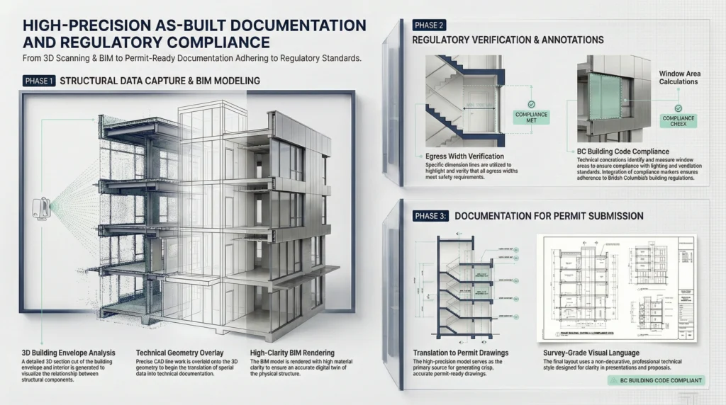
Scan to BIM can support permit and consultant coordination by documenting existing conditions before proposed work is developed. Many renovation and alteration projects require drawings that distinguish existing conditions from proposed changes. A Revit model based on laser scan data can help the design team generate more consistent plans, sections, and elevations. Scan to BIM does not guarantee permit approval, but it can support clearer documentation.
Vancouver and BC project requirements depend on the municipality, building type, occupancy, scope of work, and consultant responsibilities. A scan to BIM provider does not replace an architect, engineer, code consultant, or municipal reviewer. However, accurate existing-condition documentation can give those professionals a stronger base for their work. Property owners should treat scan to BIM as a documentation foundation, not as legal or code advice.
Scan to BIM can also help coordinate consultant input. Structural engineers, mechanical consultants, electrical consultants, interior designers, and contractors may all need to understand the same existing building. A shared model can reduce confusion when each discipline is working from the same base information. The practical recommendation is to define consultant model needs early so the scan to BIM scope supports the full project team.
Common Mistakes in Scan to BIM Projects
A common mistake is ordering a Revit model without defining the level of detail. If the provider does not know whether to model only architectural elements or also visible structure, ceilings, services, roof geometry, or equipment, the final model may not meet the project team’s needs. Over-modelling wastes budget, while under-modelling creates gaps. Buyers should define the required model content before scanning begins.
Another common mistake is assuming the point cloud automatically equals a usable BIM model. A point cloud is a measured dataset, while a BIM model is an interpreted digital representation created from that dataset. The model requires human judgement, classification, simplification, and quality control. Project managers should include both scanning time and modelling time in the schedule.
A third mistake is ignoring site preparation. Laser scanning requires visible access to the areas being captured. If rooms are locked, storage blocks walls, ceiling spaces are inaccessible, or active operations create movement, the point cloud may contain gaps or noise. These gaps can affect modelling quality. Building owners should prepare access and communicate restrictions before the scan appointment.
A fourth mistake is using scan to BIM when scan-to-CAD would be enough. A Revit model can be valuable, but not every project needs full BIM documentation. If the project team only needs 2D plans and elevations, scan-to-CAD may be more efficient. The practical takeaway is to choose the documentation method that matches the project workflow.
How to Prepare for a 3D Scanning Appointment
Building owners should prepare for a 3D scanning appointment by making all relevant areas accessible. The scanning team may need access to rooms, corridors, mechanical spaces, roof areas, basements, exterior walls, service rooms, stairwells, or tenant spaces depending on the scope. Locked doors, clutter, parked vehicles, or restricted areas can create missing information. The practical recommendation is to prepare access before the scanning team arrives.
Project teams should identify the most important spaces and elements before scanning begins. If the renovation depends on roof geometry, exposed beams, mechanical rooms, stair openings, ceiling heights, or exterior elevations, the scanning team should know this before the site visit. Clear priorities help the team plan scan positions and coverage. Buyers should not assume that every possible detail will be captured unless it is included in scope.
Facility managers should coordinate scanning around operations. Active commercial and industrial spaces may have moving equipment, employees, tenants, security procedures, or safety requirements. Scanning may need to happen during low-traffic periods or with operational support. The practical takeaway is that good coordination improves both safety and point cloud quality.
Practical Decision Matrix: Do You Need Scan to BIM?
A practical decision matrix helps determine whether scan to BIM is the right deliverable. The need for BIM depends on project complexity, design workflow, coordination risk, and the value of a 3D model. Some projects only need simple floor plans, while others require a Revit model from laser scan data. The practical rule is to choose scan to BIM when the model will directly support design, coordination, or facility decisions.
| Project situation | Recommended documentation | Why it fits |
|---|---|---|
| Basic real estate or early planning | Standard floor plans | Simple, readable, low-cost documentation |
| Home renovation with layout changes | Scan-to-CAD floor plans and elevations | Supports designers and contractors without full BIM |
| Addition or complex renovation | Scan-to-CAD or scan-to-BIM | Existing levels, rooflines, and structure may affect design |
| Revit-based architecture workflow | Scan to BIM | Allows the design team to continue in a model-based environment |
| Commercial tenant improvement | CAD or BIM depending on complexity | Helps coordinate existing layout and proposed changes |
| Industrial or facility upgrade | Scan to BIM when systems and levels are complex | Supports 3D coordination and facility documentation |
| Heritage or irregular building | Scan to BIM or detailed scan-to-CAD | Captures non-standard existing geometry more clearly |
| MEP coordination-heavy retrofit | Scan to BIM | Helps review visible systems and spatial conflicts |
The decision matrix should be reviewed with the architect, engineer, or contractor before ordering services. A provider may be able to create many deliverables, but the right deliverable depends on the end user. If the design team does not need a model, scan-to-CAD may be enough. If the design team works in Revit, scan to BIM may save time later.
The MeasureBuilt Existing Conditions Framework for Scan to BIM
The MeasureBuilt Existing Conditions Framework can be understood as a structured approach to turning physical buildings into usable digital documentation. The framework begins with project scoping, then moves into site scanning, point cloud registration, BIM modelling, quality review, and final delivery. This sequence helps prevent the common problem of collecting data before the team knows what the data must support. Project teams should start every scan to BIM project with a clear documentation goal.
The first part of the framework is scope alignment. The client and measurement team should define the building areas, required model elements, level of detail, file formats, and project use case. This step determines whether the final deliverable should be a basic Revit model, a detailed architectural model, a visible MEP model, a point cloud package, or a combination. Clear scope alignment helps avoid expensive modelling that the project team does not need.
The second part of the framework is measured site capture and point cloud control. The scan should be planned around access, visibility, building complexity, and the required deliverables. The point cloud should then be registered and checked before modelling begins. This creates a reliable measured reference for the BIM team. The practical takeaway is that a good Revit model starts with a good point cloud.
The third part of the framework is model creation and verification. BIM technicians model the agreed elements from the point cloud and review the model against the scan data. The final package should communicate assumptions, limitations, and inaccessible areas. This makes the model more useful and prevents it from being treated as more complete than the capture allowed. Project teams should ask for transparent delivery notes with the final BIM documentation.
Key Takeaways
Scan to BIM Vancouver services convert existing building conditions into Revit models through 3D laser scanning, point cloud processing, BIM modelling, and quality review. The process is useful when old drawings are missing, unreliable, or not detailed enough for renovation, retrofit, tenant improvement, or facility planning. The main benefit is a clearer digital base for design and coordination.
A point cloud is not the same as a BIM model. The point cloud is the measured spatial record, while the Revit model is a structured interpretation of that record. The quality of the final model depends on field capture, registration, modelling scope, level of detail, and verification. Project teams should define the required model content before the scanning appointment.
Scan to BIM is most valuable when the project team will actively use the model. If the project only needs simple 2D documentation, scan-to-CAD may be more efficient. If the project involves complex geometry, Revit-based design, consultant coordination, visible systems, or facility documentation, scan to BIM may provide better long-term value. The practical next step is to confirm the project workflow and required deliverables before ordering the scan.
FAQ
What is scan to BIM in Vancouver?
Scan to BIM in Vancouver is the process of capturing an existing building with 3D laser scanning and converting the resulting point cloud into a BIM model, often in Revit. The workflow helps architects, engineers, contractors, and property owners document existing conditions before renovation, retrofit, tenant improvement, or facility planning. The final model should reflect the agreed visible conditions and project scope.
What is point cloud to BIM Vancouver?
Point cloud to BIM Vancouver refers to using scanned spatial data as the basis for a building information model. The point cloud is created from 3D laser scanning and shows measured visible surfaces. BIM technicians then model walls, floors, columns, openings, roofs, stairs, and other agreed elements from that data. The result is a structured model that the project team can use for design and coordination.
How is a Revit model from laser scan data created?
A Revit model from laser scan data is created by importing or linking the point cloud into the modelling environment and building model elements that align with the captured conditions. BIM technicians interpret the scan data, create Revit elements, organize levels and views, and check the model against the point cloud. The required detail depends on the project scope and intended use.
Is scan to BIM more accurate than manual measurement?
Scan to BIM can provide a stronger existing-condition base than manual measurement when the building is complex, irregular, multi-level, or difficult to document. 3D laser scanning captures dense spatial data, while manual measurement captures selected dimensions. The final model still depends on scan quality, registration, modelling scope, and verification. Scan to BIM is most useful when accurate geometry and 3D coordination matter.
What deliverables should I expect from BIM documentation Vancouver services?
BIM documentation Vancouver services may deliver a Revit model, registered point cloud, PDF drawings, CAD exports, IFC files, floor plans, elevations, sections, or model review notes. Not every project needs every deliverable. Before ordering scan to BIM, ask which file formats are included, what elements will be modelled, what level of detail is provided, and whether the point cloud will be shared.
Can scan to BIM guarantee permit approval?
Scan to BIM cannot guarantee permit approval because permit approval depends on the proposed design, applicable regulations, municipal review, zoning, building code requirements, and consultant responsibility. However, scan to BIM can support clearer permit coordination by documenting existing conditions more reliably. Property owners should treat scan to BIM as a documentation foundation, not as legal advice or an approval guarantee.
What is the difference between scan-to-CAD and scan-to-BIM?
Scan-to-CAD converts measured site data into 2D drawings such as floor plans, elevations, and sections. Scan-to-BIM converts measured site data into a 3D model that can support model-based design and coordination. Scan-to-CAD may be enough for many renovation projects, while scan-to-BIM is more useful for complex geometry, Revit workflows, consultant coordination, and facility documentation.
Can 3D laser scanning capture hidden pipes or structure behind walls?
3D laser scanning cannot capture hidden pipes, wires, or structure behind solid walls because the scanner records visible surfaces by line of sight. Hidden conditions require other verification methods, existing records, selective opening, or specialist investigation. Scan to BIM can model visible conditions accurately within scope, but it should not be treated as proof of concealed building assemblies.
How long does scan to BIM take?
Scan to BIM timelines depend on building size, access, complexity, required level of detail, point cloud processing, and modelling scope. Field scanning may be relatively quick compared with the modelling and verification phase, but complex Revit models can take longer to produce. The best way to estimate timeline is to define the required spaces, model elements, file formats, and delivery expectations before scanning begins.
When should I choose scan to BIM instead of standard floor plans?
You should choose scan to BIM instead of standard floor plans when the project requires a Revit model, 3D coordination, complex renovation planning, visible systems coordination, facility documentation, or consultant collaboration. Standard floor plans may be enough for simple planning or real estate use. Scan to BIM is the better option when the model will directly support design, coordination, or long-term building records.
Conclusion
Scan to BIM in Vancouver gives project teams a structured way to turn existing buildings into accurate digital Revit models. The workflow begins with clear scope definition, continues through 3D laser scanning and point cloud registration, and finishes with BIM modelling, verification, and deliverable packaging. For renovations, retrofits, tenant improvements, heritage buildings, commercial spaces, and facility upgrades, scan to BIM can reduce reliance on outdated drawings and support more coordinated design decisions. The best next step is to define what the model must support, confirm the required level of detail and file formats, and choose a scan to BIM provider that explains both the capabilities and limitations of the final BIM documentation.

Analyse this page with AI
Want a summary, fact-check, or an RFP template built around these measurement standards? Send this page directly to your favourite AI model.
Content and prompt will be copied to clipboard for some models.