Precision in practice: elevating Vancouver renovations with Leica BLK 360 high-definition surveys
Discover how high definition 3D scanning in Vancouver using the Leica BLK 360 series is transforming renovation projects by delivering millimeter accuracy, rapid field capture, and seamless integration into BIM workflows.
3D SCANNING
Emil Jordan
11/20/20257 min read

The renovation market in Vancouver, spanning from heritage conversion projects in Kitsilano to high-rise interior modernizations downtown, demands uncompromising precision. In this environment, the margin for error in architectural planning is effectively zero, particularly when navigating strict local zoning bylaws and the rigorous standards set forth by provincial bodies. Consequently, forward-thinking professionals are rapidly adopting modern 3D reality capture solutions. Specifically, the utilization of the Leica BLK 360 series is fundamentally changing how accurate documentation is performed in the region, establishing high-definition 3D scanning in Vancouver as the industry standard for securing seamless, cost-effective, and code-compliant projects.
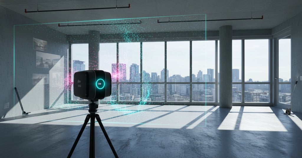
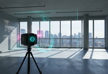
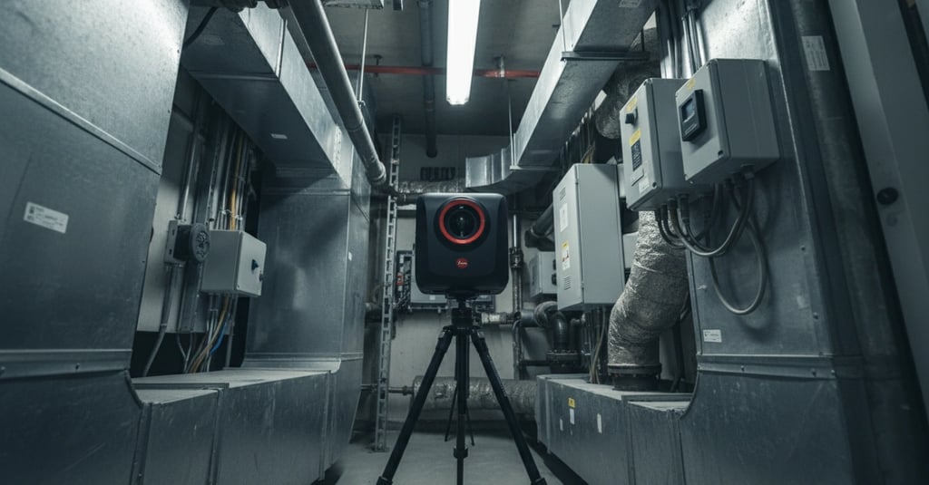
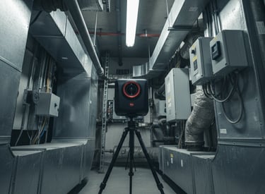
The Leica BLK 360 is not merely a measuring tool; it is a compact, robust system that captures the physical world with high-resolution 3D panoramic images overlaid onto a high-accuracy point cloud. This process transforms complex, time-consuming manual measurements into a swift, digital, and infinitely reusable data set. The democratization of 3D scanning, pioneered by the BLK 360, makes this professional-grade technology accessible for a wide array of projects, from small residential kitchen remodels to large-scale commercial retrofits.
The imperative for precision in Vancouver renovations
In the architecture, engineering, and construction (AEC) sector, precise data is the foundation of every successful project. For projects involving existing structures—the vast majority of renovation work—the need for accurate "as-built" documentation is paramount. This reality capture approach ensures that architects and designers are working with data that reflects the current, true geometry of the building, rather than outdated or inaccurate blueprints.
The limitations of traditional measurement
Traditional surveying methods often involve measuring tape, laser distance measurers (like the Leica DISTO), and manual notation. While these tools are essential, they are inherently prone to human error and data gaps, especially in the complex, cluttered, or multi-faceted environments typical of older Vancouver properties.
Key disadvantages of manual surveying:
Time consumption: manually measuring every angle, wall offset, and ceiling height is extremely time-consuming, often requiring multiple site visits to capture missing data.
Data interpretation risk: manual data collection is susceptible to individual interpretation, leading to potential inconsistencies when translating measurements into CAD or BIM models.
Lack of context: traditional measurements fail to capture the rich, visual context (like textures, colors, and non-structural details) that 3D scanning provides through high-definition panoramic imagery.
The cost of inaccurate or incomplete initial measurements is significantly high, often resulting in expensive rework, construction delays, and material waste—issues that compromise profitability and client satisfaction. Utilizing modern 3D scanning Vancouver techniques is the direct solution to mitigate these risks.
Meeting BC Building Code and safety standards
While the specific details of the BC Building Code fall outside the technical data provided for the scanner itself, professional-grade precision is the means by which all complex regulatory requirements are met. The millimeter accuracy offered by advanced 3D scanners provides the reliable measurement needed to verify structural clearances, confirm adherence to fire separations, and correctly document load-bearing element positions for engineering review.
For structural and mechanical engineers in Vancouver, the data must be irrefutable. The Leica BLK 360, particularly the newer generation, provides 4 mm accuracy at a distance of 10 m. This geometric correctness ensures that the derived models are exact, avoiding the "rounded edges" often produced by lower-grade scanners. This level of precision is indispensable for creating accurate as-built drawings BC mandates for many large renovation or conversion projects, offering clarity and control in critical processes.
Introducing the powerhouse: Leica BLK 360 technology
Leica Geosystems is renowned in the reality capture space for producing high-grade laser scanners. The BLK 360 series, including the award-winning original G1, the second-generation BLK 360 (G2), and the recently introduced SE edition, are leading this technological wave. These devices harness LiDAR technology to capture millions of individual point measurements—a "point cloud"—in a single XYZ coordinate system.
Speed and accuracy: a game changer
The efficiency of a 3D scanning Vancouver operation is determined by the speed of data acquisition and the reliability of the resulting point cloud. The BLK 360 G2 represents a massive leap forward in these aspects compared to its predecessor (G1) and many competing systems.
Point measurement rate: Leica BLK 360 G2 captures up to 680,000 pts/sec (nearly 2x faster than the G1).
Rapid capture time: The G2 can capture a full scan with spherical images in just 20 seconds (LDR), compared to approx. 2:50 minutes for the G1.
Enhanced precision: The G2 offers 4 mm accuracy at 10m, significantly more precise than the 6 mm offered by the G1.
VIS technology: The G2 features the Visual Inertial System (VIS) for automated pre-registration, a feature absent in the G1.
This incredible speed allows users performing an architectural survey Vancouver to complete large job sites much faster. Teams can rapidly move from setup to setup, ensuring minimal interruption to the site or tenants. Furthermore, the G2 utilizes a 4-camera system with 13 megapixels each, capturing 5-bracket HDR spherical images. This high dynamic range imaging is crucial for difficult lighting conditions—such as bright Vancouver sunlight streaming through large windows combined with dark interior shadows.
Portability and ease of use
The BLK 360 is built for mobility, a critical factor for professionals moving frequently between diverse sites across the Lower Mainland.
The second-generation BLK 360 design features:
Compact form factor: measuring just 155 mm in height and 80 mm in diameter.
Lightweight build: weighing only 0.75 kg (0.85 kg including the battery), a 20% reduction compared to the original.
One-button operation: designed to be operated autonomously with a single button, making scanning straightforward and accessible.
This portability allows the scanner to be easily transported and set up in tight spaces, such as crowded mechanical rooms or small residential bathrooms—common constraints in Vancouver renovation projects.
The workflow of modern 3D scanning Vancouver
A critical advantage of utilizing Leica BLK 360 services is the seamless digital workflow, spanning from quick field capture to instant data registration and final export into industry-standard design software.
Field capture with the Leica BLK 360
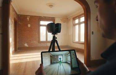
The scanning process is controlled intuitively via mobile applications, ensuring real-time feedback and quality control directly on site. The scanner can be controlled either autonomously or remotely via a connected mobile device using apps like Leica Cyclone FIELD 360.
The capture process:
1. Setup: The scanner is mounted on a tripod or placed on a flat surface.
2. Connection: The device broadcasts its own Wi-Fi signal for real-time data transfer to a smartphone or tablet.
3. Resolution selection: Users choose preset resolutions (e.g., 6/12/25/50 mm @ 10 m) based on the detail required for the interior laser scanning task.
Real-time registration with VIS technology
For professional firms providing architectural survey Vancouver services, the Visual Inertial System (VIS) in the G2 model is a game changer.
VIS explained: It combines video-enhanced inertial measurement units (IMU) and camera tracking to monitor the scanner's movement.
Automated alignment: The system tracks where the scanner is located at all times. Each subsequent scan is automatically aligned with the previous one while the operator is still on site.
Efficiency: This automation means that 95-97% of scan positions are correctly merged immediately, significantly reducing post-processing time.
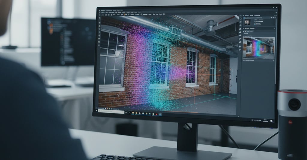
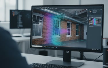
Post-processing and deliverables
Once field work is complete, data is transferred via Wi-Fi or USB-C to desktop software like Leica Cyclone REGISTER 360 for final cleaning and verification. The final data is exported in formats essential for collaboration in the AEC industry:
E57: A universal, non-proprietary point cloud format.
RCP/RCS: Autodesk's native formats for integration into AutoCAD and Revit.
LGS: Leica's proprietary lightweight format containing all data and photos.
The finalized model is used to generate high-quality as-built drawings BC firms rely on, including detailed 2D floor plans, 3D BIM models, and digital twins.
Specialized applications for architectural survey Vancouver needs
The versatility and high-definition output of the Leica BLK 360 make it applicable far beyond simple surveys. Its application spans the entire construction lifecycle.
Interior laser scanning: capturing complex spaces
Interior laser scanning presents unique challenges in renovation projects, often involving irregular walls, tight spaces, and complex piping. The BLK 360 is perfectly suited for these environments.
For instance, when documenting conditions for kitchen or bathroom remodeling in Vancouver homes, the BLK 360 captures intricate geometries with the necessary millimeter precision. This detail is critical for bespoke elements such as custom cabinetry, countertop fabrication, and complex HVAC installations.
Applications beyond as-built documentation
Building Information Modeling (BIM): The dense point cloud enables "Scan to BIM," allowing for immediate clash detection and constructability reviews.
Historical preservation: The BLK 360 creates precise digital models of heritage sites, ensuring complex architecture is documented for restoration.
Virtual Reality (VR): HDR spherical imagery combined with point clouds allows for immersive client presentations and real estate marketing.
Progress monitoring: Periodic scanning allows construction managers to monitor progress against the design model, ensuring accuracy and schedule adherence.
Choosing the right Leica BLK 360 model
Leica Geosystems offers highly capable variants in the BLK 360 line. Choosing the right one depends on project size, desired speed, and budget.
BLK 360 G2: the high-end standard for AEC
The G2 model is the definitive choice for high-volume, time-critical, or complex projects.
Maximized productivity: The 680,000 pts/sec capture rate and VIS system ensure maximum efficiency.
Large projects: Ideally suited for multi-story buildings or large industrial areas where registration time must be minimized.
Fastest transfer: Features enhanced Wi-Fi and USB-C 3.0.
BLK 360 SE: precision meets affordability
The SE (Standard Edition) is designed for optimal price-performance for small-to-mid-sized projects.
Speed: Captures 340,000 pts/sec (roughly half the speed of the G2).
No VIS technology: Registration must be done manually or in office software.
Target audience: Ideal for smaller architecture studios or specialized trade contractors (e.g., millworkers) where cost-efficiency outweighs the need for maximum speed.
Conclusion: securing success through advanced reality capture
The rapid adoption of high-precision 3D scanning in Vancouver reflects a clear shift toward digital, data-driven methodology. For the demanding and competitive renovation market, the Leica BLK 360—especially the powerful G2 model—provides the essential tools for success.
Firms that embrace Leica BLK 360 services are investing in reliability, efficiency, and safety. By replacing error-prone manual methods with rapid, millimeter-accurate scanning, architects, interior designers, and contractors can ensure their as-built drawings BC are flawless. This technology transforms the complex task of capturing reality into a simple operation, establishing a solid digital foundation that allows professionals to build with confidence.
MeasureBuilt
Address
413-8188 Manitoba Street
Vancouver, BC V5X 4L8
Contacts
236-232-3335
emil@measurebuilt.com
When Details Matter!