Rapid mobile mapping: the benefits of handheld LiDAR scanning (SLAM 100) for complex sites in Vancouver
Explore how handheld SLAM 100 LiDAR scanning delivers fast, precise 3D reality capture in Vancouver — from heritage homes to high rise developments — saving time and ensuring survey grade accuracy for renovation, BIM, and construction planning.
3D SCANNING
Emil Jordan
12/4/20259 min read
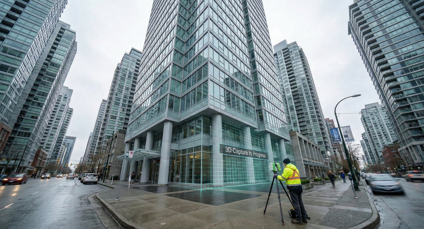
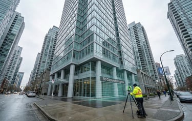
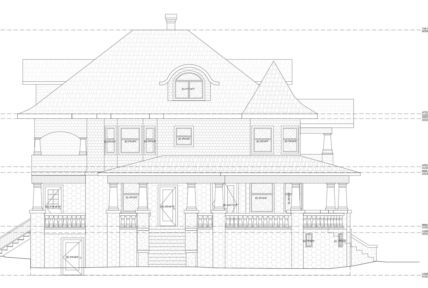
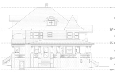
In the dynamic and often structurally complex landscape of Vancouver's built environment, traditional methods of site measurement are increasingly proving inadequate for the speed and precision demanded by modern construction and renovation planning. The industry now requires a solution capable of generating highly detailed, accurate spatial data efficiently. This imperative has solidified the position of mobile LiDAR scanning in Vancouver as the leading methodology for reality capture. Handheld devices, such as the SLAM 100, deliver exceptional 3D laser scanning services, turning complicated, feature-rich sites - from sprawling high-rise developments to intricate Victorian heritage homes - into quantifiable, actionable data, including highly accurate floor plans, elevations and site plans.
The technological edge: how SLAM revolutionizes mobile LiDAR scanning in Vancouver
LiDAR (Light Detection and Ranging) technology uses laser pulses to measure distances and create precise 3D point clouds of spaces, assets, and objects. While LiDAR systems have long been essential instruments in surveying, the revolutionary development was the creation of portable and lightweight handheld devices. These portable LiDAR scanners integrate sophisticated algorithms, marking a significant leap in efficiency, speed, and accuracy for building documentation.
The core of this efficiency lies in the technology known as Simultaneous Localization and Mapping (SLAM).
Defining SLAM: localization and mapping in real-time
SLAM is a transformative technology that allows mobile systems to simultaneously build and update a map of their surrounding environment while precisely determining their location within that map. Originally developed for robotics, SLAM has been successfully implemented across various surveying applications, ranging from handheld scanners and backpack systems to vehicle-mounted and drone applications.
Handheld laser scanners equipped with SLAM technology capture detailed 3D maps in real-time. These scanners measure distances using laser beams to create point clouds that represent the environment. The SLAM algorithms continuously process this data to identify unique features and landmarks, constantly updating the map as the operator moves. This continuous feedback loop ensures that the scanner accurately maintains its location within the mapping system, even when navigating complex and dynamic settings.
The best mobile mapping systems utilize a combination of LiDAR and RGB cameras to capture a densely colored, photorealistic 3D dataset of the structure. This data is intuitive to navigate, explore, and measure, even for stakeholders unfamiliar with traditional point clouds. Crucially, leading mobile mapping devices provide real-time feedback via a tablet display, showing the quality of the capture as the work is being performed. If an area is missed, the screen immediately indicates this, allowing the operator to correct the scan on the spot.
Superior accuracy in challenging environments
Handheld SLAM systems offer high precision, making them valuable tools for obtaining precise and accurate data with minimal effort. The output of sophisticated SLAM technology can be highly detailed 3D point clouds, with a point spacing density comparable to terrestrial laser scanning (TLS), sometimes reaching 2 mm spacing.
The SLAM 100, specifically, delivers impressive results, achieving:
Relative accuracy: up to 2 cm.
Absolute accuracy: up to 5 cm.
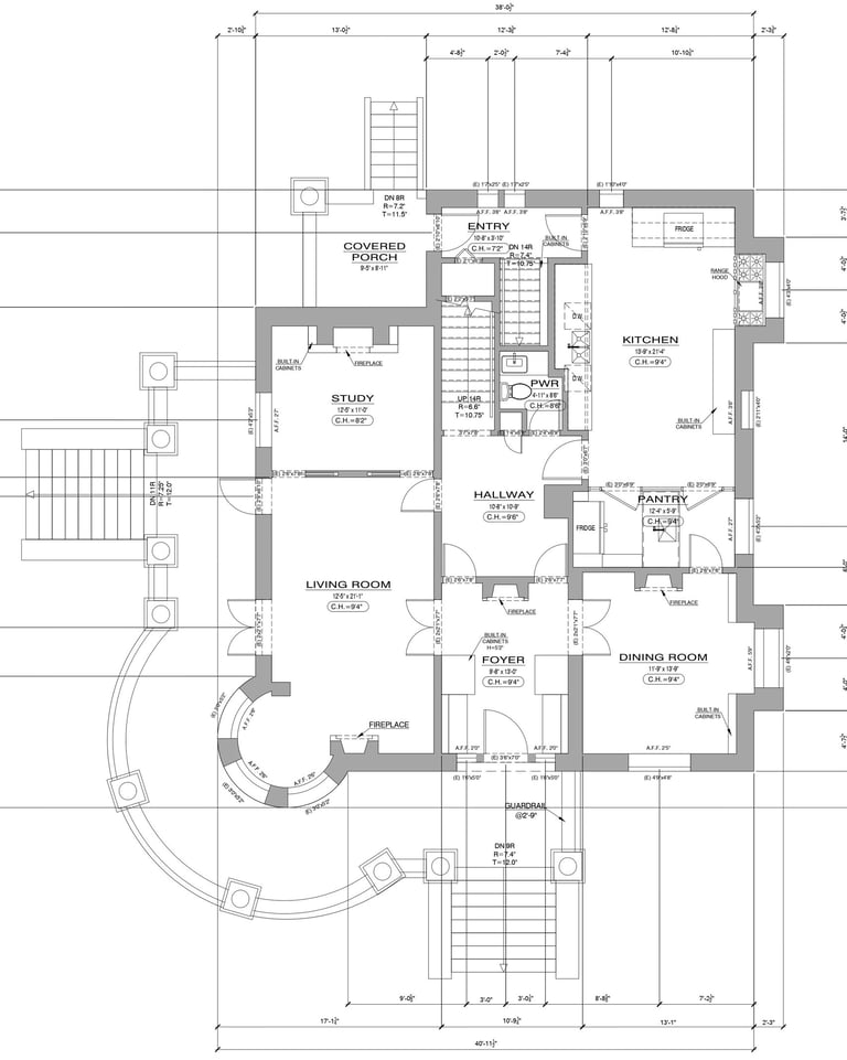
These systems are capable of producing georeferenced survey-grade accuracy after post-processing and geo-referencing, typically ranging from 6-15 mm for absolute accuracy depending on the environment and processing method. This level of precision is critical for professional applications such as LOD 300 BIMs or floor plans rendered at a scale of up to 1:50.
Handheld SLAM vs. terrestrial laser scanning: a workflow comparison
For complex sites and large assets, the adoption of handheld SLAM LiDAR is driven primarily by efficiency gains relative to traditional static Terrestrial Laser Scanning (TLS).
Comparison of key features:
Mobility: handheld units easily navigate tight, complex, or hard-to-reach areas, whereas TLS is typically stationary.
Setup time: SLAM devices are designed for rapid deployment and dynamic movement, unlike TLS which requires multiple setups and calibration.
Data capture: handheld devices allow for rapid mobile mapping, capturing massive data swathes on the go.
Real-time output: SLAM provides immediate 3D visualization and mapping feedback during the scan, while TLS data registration is typically performed after field work.
The most compelling argument for adopting mobile LiDAR scanning in Vancouver is the dramatically reduced time required on-site.
GPS-independent mapping: conquering urban canyons
A significant benefit of SLAM-based laser scanners is their ability to survey effectively in environments where Global Positioning System (GPS) signals are degraded or entirely unavailable. SLAM systems function independently of GPS.
This makes mobile scanning in Vancouver ideally suited for challenging regional infrastructure and properties, including:
Indoor spaces and basements: SLAM systems perform real-time mapping in enclosed spaces where GPS is unavailable.
Tunnels and underground spaces: the SLAM 100 has been used for capturing data in underground spaces and metro tunnels, eliminating the need for splicing operations.
Urban canyons: in dense urban areas like downtown Vancouver, high-rise buildings often hinder GPS signals, but SLAM maintains accurate localization.
Industrial facilities: complex manufacturing plants often have obstructed views and challenging geometries.
Furthermore, LiDAR-based SLAM systems are capable of operating with little to no light, making them perfect for inspections or surveying hard-to-reach areas during off-hours.
Unlocking efficiency for home renovation projects in Greater Vancouver
For architects, interior designers, and contractors tackling home renovation projects in Greater Vancouver, the initial site assessment is the foundation of success. Errors introduced at the measurement stage propagate throughout design, procurement, and construction, leading to costly delays. Handheld LiDAR scanning mitigates these risks by providing an immediate, verifiable digital record of existing conditions.
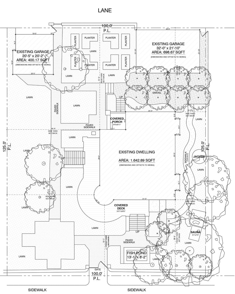
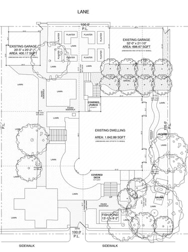
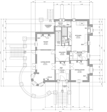
From existing conditions to accurate floor plans
The speed and portability of handheld scanners drastically reduce the time needed to capture existing conditions. This is particularly advantageous for retrofitting and restoration projects where precise measurements are paramount.
By creating detailed 3D models of the structure, professionals can quickly generate accurate floor plans and elevation data. These accurate data sets simplify the process of understanding topography and identifying potential issues like uneven ground before renovation planning begins.
Key advantages for floor plan generation:
Comprehensive view: handheld scanners can capture both the exterior and interior of a building, providing a thorough view.
High detail: the capability to achieve millimeter-level density in point clouds means fine architectural details are preserved.
Digital deliverable: the output is typically compatible with industry-standard file formats (such as LAS and E57) and can be easily imported into preferred design software.
Streamlining renovation planning and design
Renovation planning demands a meticulous understanding of what currently exists versus what is intended. Handheld LiDAR scanners accelerate the initial site assessment and data preparation phases, directly leading to faster project delivery.
Mobile scanning systems integrate effectively with Building Information Modeling (BIM) workflows. The generated 3D data, often referred to as "Scan-to-BIM," allows architects and engineers to:
Create digital twins: use collected data to build a virtual model of the site, assisting in designing new structures that fit perfectly with the existing topography.
Informed decisions: integration into BIM systems provides more precise and informed design decisions, minimizing clashes and structural conflicts.
Reduced modeling time: industry reports suggest that integrating mobile scanning with BIM workflows can reduce modeling time by up to 60% on complex renovation projects.
Critical advantages for professionals: architects, designers, and contractors
The versatility and high-definition output of devices like the SLAM 100 make them essential interior designer tools and invaluable for construction professionals focused on efficiency and cost control.
Empowering interior designer tools and vision
Interior design often hinges on maximizing tight tolerances and understanding volumetric constraints, especially in older Vancouver homes. The ability to capture detailed 3D models quickly allows interior designers to integrate their vision with real-world dimensions instantly.
The SLAM 100 includes three 5MP cameras designed to synchronously capture texture information, allowing for the creation of color point clouds and partial panoramic images. This photorealistic documentation is crucial for design presentations and client engagement.
Designers can utilize this data for:
Accurate volume measurement: capturing volume data for material estimation and layout planning.
Virtual walkthroughs: generating 360° virtual tours from the mobile mapping device.
Feature-rich models: utilizing high-resolution point clouds to detect and model architectural features (millwork, niches) that influence design decisions.
Enhancing contractor estimates and project management
Contractors operate in a highly competitive market where accurate pricing and timely project completion are paramount. The reliability of precise measurements derived from mobile LiDAR scanning in Vancouver directly translates into superior project management.
Handheld LiDAR dramatically improves the reliability of contractor estimates by:
Minimizing unknowns: accurate spatial data eliminates guesswork associated with manual measurements, reducing the risk of material overages.
Faster estimation cycles: the rapid capture speed reduces the lead time required to gather measurement data, allowing contractors to produce timely and competitive bids.
Quality control checks: regular scanning during construction monitors progress and ensures adherence to design specifications, enabling quick identification and correction of deviations.
Construction documentation and compliance
For both large-scale commercial builds and detailed home renovation projects in Greater Vancouver, robust construction documentation is non-negotiable, particularly when dealing with municipal requirements for building permit drawings and final inspections.
SLAM LiDAR scanners support stringent documentation standards throughout the entire project lifecycle:
1. Initial site assessment: detailed terrain mapping ensures new construction does not interfere with surrounding elements.
2. During construction: regular scanning tracks construction progress against the timeline and design specs. LiDAR scanners detect deviations from the planned design, enabling rapid corrective actions.
3. Post-construction: LiDAR scanning delivers a detailed view of the finished structure, essential for final inspections and construction documentation.
While the sources do not specifically cite the BC Building Code, the detailed, high-accuracy deliverables provided clearly align with the high standards of spatial documentation required for municipal building permit processes.
The SLAM 100 advantage: technical specifications and performance
The SLAM 100 Industrial Handheld 3D LiDAR Mobile Laser Mapping Scanner System is a powerful example of mobile mapping technology designed for obtaining high-precision data in complex environments.
Precision data capture features:
Rotating head: includes a 360° rotating head providing a comprehensive 270°x360° point cloud coverage.
LiDAR range: utilizes a 16-channel laser head with a range of up to 120 meters and a point generation rate of 320,000 points per second.
Integrated cameras: three integrated 5MP cameras synchronize texture information capture, forming a horizontal 200° Field of View.
Portability: lightweight and compact design operating on internal batteries for up to 2.5 hours.
Software ecosystem:
The efficiency of mobile LiDAR scanning in Vancouver is enhanced by the integrated software ecosystem. The SLAM GO App connects to the scanner for real-time data display (3D/2D) ensuring high-quality acquisition. SLAM GO POST PRO software performs high-precision point cloud mapping, optimization, and panoramic image generation.
Accelerating real estate and permit processes
The Vancouver real estate market demands swift and precise documentation. Mobile LiDAR scanning benefits property owners by accelerating the provision of essential documents like real estate floor plans.
Generating real estate floor plans quickly
Accurate floor plans are paramount for marketing and legal documentation. Handheld SLAM scanners drastically shorten the time from site visit to finalized documentation.
Minimal disruption: handheld mapping is less intrusive and remarkably fast, beneficial in sensitive urban environments.
Rapid delivery: a building can be scanned and a detailed 3D model generated in a fraction of the time required by manual methods.
Intuitive visuals: resulting photorealistic 3D models provide realistic site reproduction, offering a better data carrier for virtual tours.
Supporting building permit drawings with reliable data
The foundation of any successful municipal application in Greater Vancouver is accurate building permit drawings based on verifiable site conditions.
Survey-grade accuracy: post-processed point clouds can be geo-referenced to survey-grade accuracy.
Detailed documentation: millions of data points provide definitive as-built documentation.
Change analysis: mobile scanning systems can analyze changes in real-time or post-facto to compare existing conditions against design models.
Conclusion: the future of spatial data acquisition in Vancouver
For property owners, developers, architects, and the entire ecosystem supporting home renovation projects in Greater Vancouver, embracing handheld LiDAR technology marks a transition from approximate manual methods to definitive digital workflows. The SLAM 100 offers a solution that meets the highest demands of accuracy and speed required for complex projects.
By utilizing SLAM technology, professionals can generate accurate floor plans and robust construction documentation quickly and reliably, even in GPS-denied environments. These 3D laser scanning services are essential interior designer tools and provide the foundation for solid contractor estimates, streamlining renovation planning and the preparation of building permit drawings. The ability to deliver precise real estate floor plans rapidly also accelerates market activities and stakeholder coordination.
Contact Us
MeasureBuilt
Address
413-8188 Manitoba Street
Vancouver, BC V5X 4L8
Contacts
236-232-3335
emil@measurebuilt.com
When Details Matter!