Large-scale accuracy: how Faro Focus elevates industrial 3D scanning in Vancouver
Discover how Faro Focus laser scanning revolutionizes industrial 3D scanning in Vancouver with millimeter precision, safety benefits, and seamless BIM integration for construction, utilities, and facility management.
3D SCANNING
Emil Jordan
11/26/20257 min read
The rapidly evolving landscape of construction and infrastructure management in Western Canada demands levels of precision that traditional measurement methods simply cannot deliver. In this high-stakes environment, where millimeter accuracy dictates project success and regulatory compliance, the adoption of advanced reality capture technology is not merely optional—it is mandatory. Specifically, the sophisticated capabilities of the Faro Focus laser scanner are transforming the standard practice for industrial 3D scanning in Vancouver. This technological shift provides experienced architects, general contractors, and facility owners with an invaluable digital toolset for planning, verification, and long-term asset management, ensuring that complex projects across the Lower Mainland meet the highest benchmarks of quality and efficiency.
The new standard in reality capture: why Faro Focus technology dominates large-scale projects
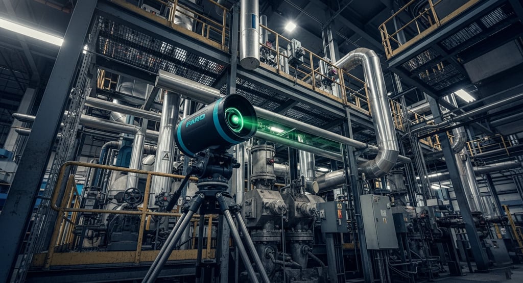
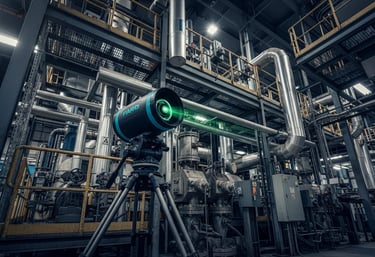
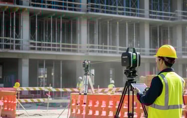
For projects ranging from complex utility retrofits to high-rise construction monitoring, precision is the bedrock of constructibility. Faro Focus technology, often utilized in a comprehensive Faro Focus survey, has emerged as a leader in reality capture, providing highly accurate proximity data necessary for critical decision-making throughout the project lifecycle.
Traditional surveying relies on time-consuming, point-by-point measurements, which are inherently prone to human error and logistical constraints. In contrast, tripod-mounted laser scanners, such as the Faro Focus, capture millions of data points per second, resulting in a dense, comprehensive, and non-contact spatial record known as a point cloud.
Precision beyond traditional methods
The value of this technology lies in its ability to capture the geometric characteristics of physical objects and environments with unparalleled detail. For large structures, mapping can achieve millimeter accuracies. Key characteristics demonstrating this superior precision include:
Massive data collection: high-definition surveying (HDS) equipment can measure tens of thousands of points per second, creating detailed 3D models of any object, structure, or terrain. A phase-based scanner can emit nearly a million laser points per second, collecting a 360-degree scan in minutes.
Comprehensive documentation: unlike manual surveys that risk omitting critical details, 3D laser scanning captures the entirety of an environment, ensuring that the final data set—the point cloud—is a complete snapshot of current conditions.
Accuracy for large volumes: the Faro Focus is particularly suited for scanning very large objects, such as houses or entire industrial plants, effectively combining individual 3D scans to overcome practical size limitations.
By delivering this level of geometric fidelity, a detailed Faro Focus survey provides the necessary confidence to execute projects requiring stringent dimensional control, limiting design conflicts and minimizing fit-up problems that often cause expensive construction rework.
The new standard in reality capture: why Faro Focus technology dominates large-scale projects
For projects ranging from complex utility retrofits to high-rise construction monitoring, precision is the bedrock of constructibility. Faro Focus technology, often utilized in a comprehensive Faro Focus survey, has emerged as a leader in reality capture, providing highly accurate proximity data necessary for critical decision-making throughout the project lifecycle.
Traditional surveying relies on time-consuming, point-by-point measurements, which are inherently prone to human error and logistical constraints. In contrast, tripod-mounted laser scanners, such as the Faro Focus, capture millions of data points per second, resulting in a dense, comprehensive, and non-contact spatial record known as a point cloud.
Precision beyond traditional methods
The value of this technology lies in its ability to capture the geometric characteristics of physical objects and environments with unparalleled detail. For large structures, mapping can achieve millimeter accuracies. Key characteristics demonstrating this superior precision include:
Massive data collection: high-definition surveying (HDS) equipment can measure tens of thousands of points per second, creating detailed 3D models of any object, structure, or terrain. A phase-based scanner can emit nearly a million laser points per second, collecting a 360-degree scan in minutes.
Comprehensive documentation: unlike manual surveys that risk omitting critical details, 3D laser scanning captures the entirety of an environment, ensuring that the final data set—the point cloud—is a complete snapshot of current conditions.
Accuracy for large volumes: the Faro Focus is particularly suited for scanning very large objects, such as houses or entire industrial plants, effectively combining individual 3D scans to overcome practical size limitations.
By delivering this level of geometric fidelity, a detailed Faro Focus survey provides the necessary confidence to execute projects requiring stringent dimensional control, limiting design conflicts and minimizing fit-up problems that often cause expensive construction rework.
Revolutionizing industrial 3D scanning in Vancouver: applications and value
The specific demands of the industrial sector in British Columbia—encompassing everything from major water treatment facilities to port terminals and refineries—require extreme precision and rapid turnaround. High-accuracy scanning is fundamental to this goal.
Petrochemical, energy, and utility infrastructure
Industrial facilities, characterized by complex piping systems and large machinery, pose immense challenges for traditional measurement. Laser scanning provides the ideal solution for documenting, planning, and maintaining these critical assets.
Typical applications include:
As-built documentation: capturing detailed geometric data of piping and entire plants. This is especially useful for older facilities where original CAD data may be lost.
Plant retrofitting and expansion: precise data is crucial for planning changes in existing (Brownfield) projects. Scanning facilitates the simulation of new equipment integration and early clash detection.
Infrastructure surveying: scanning supports detailed engineering survey in BC projects related to large-scale industrial equipment and electrical substations.
Facility management: the creation of an accurate digital twin serves as a long-term record of existing conditions, invaluable for maintenance and remote onboarding of contractors.
Advanced manufacturing and quality control
Beyond infrastructure, industrial scanning is indispensable in manufacturing sectors where dimensional accuracy dictates product quality. For manufacturers in Vancouver, 3D scanning simplifies quality control and accelerates development cycles.
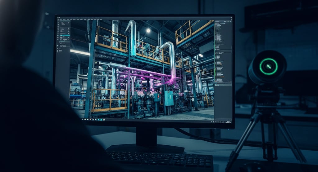
Quality control & metrology: scanning allows for precise "as-built" verification against "as-designed" CAD models, revealing deviations via color-coded analysis with precision as high as 0.05 mm.
Reverse engineering: when original technical drawings are missing for legacy parts, 3D scanning captures existing geometry to create new CAD models, vital for spare part production.
Prototyping and development: scanning rapidly captures prototypes, allowing developers to quickly iterate designs during the product development lifecycle.
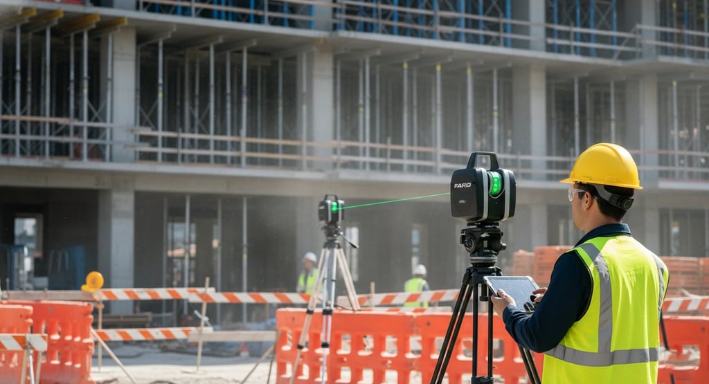
Enhancing construction site scanning and BIM workflows
In Vancouver's robust construction sector, the trend towards digital delivery and Building Information Modeling (BIM) mandates highly reliable reality capture. Construction site scanning is the foundation for virtually all modern BIM-enabled projects.
From point cloud to BIM: the scan-to-BIM mandate
Scan to BIM is the transformative process where raw point cloud data is converted into an intelligent, editable BIM model. This approach is crucial for renovation and repurposing existing property, drastically reducing errors in the design phase.
The process involves collecting data with high-precision scanners, processing the point clouds, and meticulously transforming them into a detailed BIM model compatible with major platforms like Revit. This digital representation delivers an accurate digital twin configuration, supporting asset management throughout the building's lifecycle.
Mastering MEP clash detection and coordination
A primary benefit of construction site scanning is its utility in managing the complexity of mechanical, electrical, and plumbing (MEP) systems.
Proactive conflict identification: MEP Scan to BIM facilitates effective clash detection, allowing project teams to identify design conflicts before physical construction begins.
Accurate as-built documentation: detailed spatial data ensures that constructed MEP components align perfectly with the design intent.
Coordination between trades: the BIM model serves as a single source of truth, enhancing coordination and communication among different trades.
As-built verification and compliance
For architects and developers operating under local regulations, such as the BC Building Code, compliance is non-negotiable. 3D scanning provides the ultimate tool for verifying the as-built condition against design specifications.
Verifiable accuracy: scanning delivers verified as-built drawings essential for future reference.
Monitoring progress: scanning can be used to monitor construction progress, comparing the site's current state with the theoretical model to detect deviations immediately.
Heritage preservation: for Vancouver's heritage properties, non-destructive scanning ensures restoration complies strictly with historical and structural requirements.
Point cloud services Vancouver: the core deliverable
The most immediate output of a high-resolution 3D scan is the point cloud. Accessing high-quality point cloud services Vancouver provides stakeholders with the raw, highly precise spatial data necessary to drive sophisticated digital workflows.
Data integrity and software integration
A quality point cloud is achieved through rigorous professional procedures. Professionals utilize specialized software to clean, align, and refine individual clouds, ensuring geometric accuracy.
Once generated, the data integrates seamlessly with industry-standard platforms:
CAD platforms: integrate with AutoCAD and Civil 3D for extracting 2D plans and sections.
BIM platforms: transform data into editable models within Revit and ArchiCAD.
Specialized analysis: enable detailed analyses such as deformation studies and volume calculations.
This foundational data allows engineering survey in BC firms to accelerate workflows and provide reliable measurements for complex infrastructure.
Strategic advantages for Vancouver stakeholders
The technological advancements offered by high-accuracy laser scanning provide distinct competitive advantages across Vancouver's building sector.
For property owners: high-precision scans provide accurate measurements for transactions and simplified planning for renovations. Immersive "digital twins" allow remote stakeholders to visit the site virtually.
For architects: scanning provides a reliable design baseline, eliminating reliance on old paper drawings. It ensures seamless integration with design software and faster project turnaround.
For contractors: the primary benefits are cost savings and risk reduction. By avoiding costly errors and rework through clash detection, the overall cost of ownership is lowered. High-accuracy scans also support offsite prefabrication, reducing downtime.
Conclusion: the future of accuracy in British Columbia
The era of relying on antiquated tools and imprecise measurements is rapidly fading in Vancouver's sophisticated construction and industrial sectors. Through the specialized capabilities of advanced terrestrial laser scanners, such as the Faro Focus, stakeholders now have access to reality capture data defined by unparalleled accuracy, speed, and completeness.
The detailed digital twin created through a Faro Focus survey powers mission-critical workflows, including rapid construction site scanning, precise quality control in manufacturing, and mandatory clash detection in industrial retrofits. High-fidelity point cloud services Vancouver provide the essential data format that elevates project certainty and compliance across every discipline. By embracing this level of technological precision, professionals in British Columbia are building better, faster, safer, and more sustainably, securing the foundation for Vancouver's future infrastructure.
Contact Us
MeasureBuilt
Address
413-8188 Manitoba Street
Vancouver, BC V5X 4L8
Contacts
236-232-3335
emil@measurebuilt.com
When Details Matter!