As-Built Drawings Vancouver: Guide to 3D Scanning & Permits
Master your renovation with as-built drawings Vancouver experts trust. Use 3D laser scanning for millimeter accuracy, BC code compliance, and faster permits.
3D SCANNING
Emil Jordan
4/21/20264 min read
As-built drawings are the definitive, precise record of a building's current condition. They capture all deviations from the original architectural design and reflect the true physical reality of a structure after construction, renovation, or modification.
For any project in Vancouver, securing professional as-built drawings trusted by contractors, architects, and engineers is essential. They are critical for municipal permit approvals, minimizing costly construction changes, and ensuring full compliance with the Vancouver Building Code.
Modern 3D laser scanning has transformed this process, delivering millimeter-level accuracy from the start and significantly reducing the financial risks associated with manual measurement methods.
Why As-Built Drawings Matter in Modern Construction
The foundation of any successful renovation, tenant improvement, or structural addition is accurate construction documentation that municipalities and consultants can rely on.
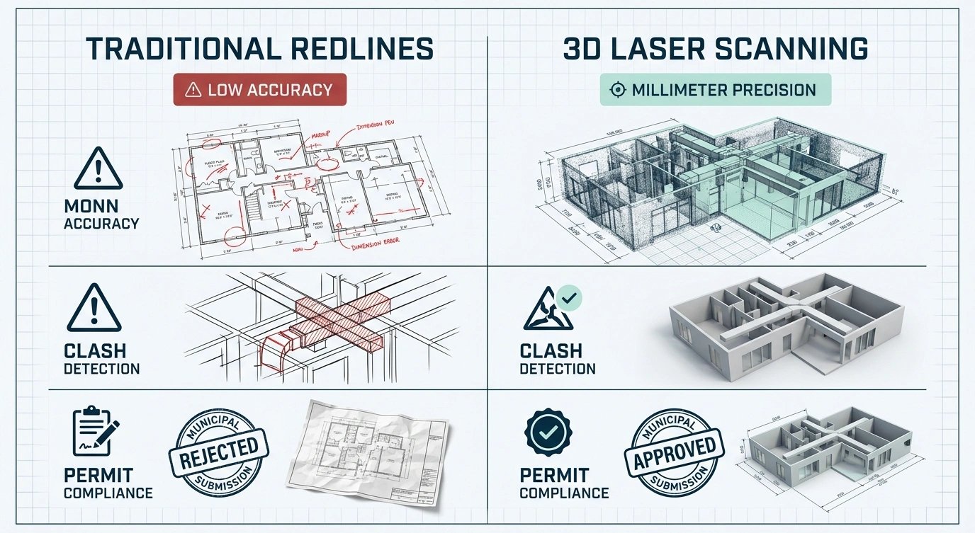
Outdated redline markups and manual sketches introduce significant risks, including design errors, site conflicts, and costly rework. Today, advanced reality capture methods such as 3D laser scanning allow professionals to generate a complete digital representation of existing conditions - often referred to as the digital twin of a building.
This verified data stream supports smoother building permit applications across Greater Vancouver and ensures that design decisions are based on accurate field conditions, not assumptions.
Studies show that a large portion of construction rework originates from poor or incomplete project data. High-quality as-built drawings eliminate this risk by providing a reliable spatial baseline before design begins.
Core Industry Shift: From Manual Measurements to Reality Capture
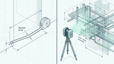
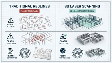
Traditional construction documentation relied on hand measurements and redline markups over original drawings. While still used in some cases, this approach is highly prone to human error and incomplete data capture.
Modern workflows now rely on:
Terrestrial 3D laser scanning
Dense point cloud data capture
Scan-to-BIM modelling workflows
Digital coordination across disciplines
These technologies have fundamentally changed how existing buildings are documented and designed.
BC Building Code Considerations
The British Columbia Building Code establishes strict requirements for structural safety, occupancy, and life safety systems. Accurate as-built documentation is essential when:
Modifying structural elements
Upgrading MEP systems (mechanical, electrical, plumbing)
Applying for renovation or change-of-use permits
Verifying compliance with current safety standards
Municipal reviewers rely on accurate drawings to assess whether proposed changes meet code requirements.
Renovation Workflows in Greater Vancouver
Successful renovation projects depend on seamless coordination between surveyors, architects, engineers, and contractors.
Starting with accurate as-built floor plans ensures:
Reliable design development
Reduced site verification visits
Fewer RFIs and change orders
Improved prefabrication accuracy
Faster project timelines
Without a verified spatial baseline, downstream design and construction decisions become significantly more uncertain.

Measurement Accuracy and Quality Assurance
Manual measurement methods are inherently limited. They often fail to capture:
Wall plumbness and deflection
Ceiling height variations
Complex MEP routing
Structural irregularities
In contrast, 3D laser scanning captures millions of spatial data points and typically achieves 1–4 mm accuracy, depending on site conditions and scanner technology.
This level of precision significantly improves design reliability and reduces construction risk.
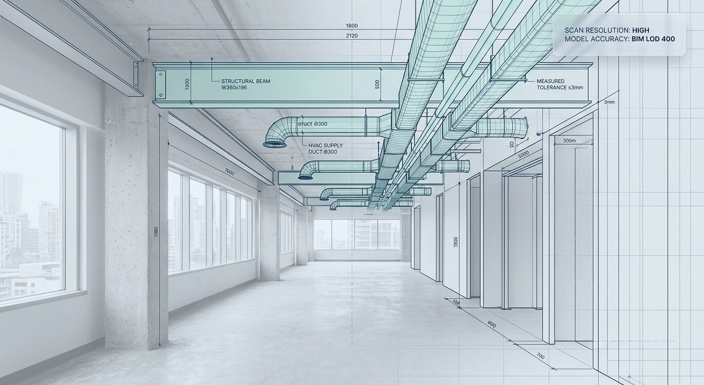

Scan-to-BIM and Digital Deliverables
The industry is rapidly shifting toward Building Information Modeling (BIM), where spatial data is converted into intelligent 3D models.
A Scan-to-BIM workflow transforms point cloud data into:
AutoCAD (DWG) drawings
Autodesk Revit (RVT) models
Coordinated architectural and MEP layouts
Clash detection-ready digital environments
These models reflect real-world conditions and enable architects and engineers to design with confidence.
Risk Mitigation and Cost Control
Inaccurate or incomplete site data is one of the leading causes of construction rework.
Key risks include:
Design clashes discovered during construction
Fabrication errors in millwork or steel
Permit delays due to inconsistent drawings
Budget overruns from change orders
High-quality as-built documentation mitigates these risks early. In many cases, a relatively small investment in laser scanning can prevent significantly larger construction costs later in the project lifecycle.
When You Need As-Built Drawings or Laser Scanning
As-built documentation is essential when:
Original drawings are missing or outdated
Major renovations or tenant improvements are planned
Structural modifications are required
Permit applications demand verified existing conditions
Complex MEP systems must be coordinated
In Vancouver's dense urban environment, many buildings lack reliable archival documentation, making reality capture a critical first step.
Technical Breakdown: Accuracy and Deliverables
Modern surveying workflows typically include:
Terrestrial laser scanning (1–4 mm accuracy)
Unified point cloud datasets
2D CAD floor plans and elevations
3D BIM models (LOD depending on scope)
These deliverables allow design teams to work directly from verified site conditions instead of assumptions.
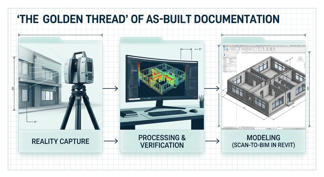
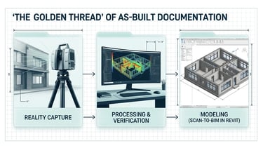
Methodology: How As-Built Data Is Created
Professional reality capture follows a structured workflow:
1. Reality Capture – 3D laser scanning of existing conditions 2. Data Processing – point cloud registration and verification 3. Model Development – conversion into CAD/BIM formats 4. Quality Control – cross-checking against field conditions
This process ensures a continuous and traceable "digital thread" of building information.
Common Myths About As-Built Drawings
Myth 1: Hand measurements are sufficient
Reality: They cannot reliably capture irregular geometry or structural deviations.
Myth 2: Laser scanning replaces surveyors
Reality: Surveyors define legal boundaries; scanning captures physical conditions. Both are required in many projects.
Myth 3: Redlines are equivalent to as-builts
Reality: Redlines are informal and prone to error; measured drawings are verified and precise.
Myth 4: Only large projects need as-builts
Reality: Residential and small-scale renovations often benefit the most from accurate documentation.
FAQ
What is the difference between as-built and construction drawings?
Construction drawings represent design intent, while as-builts reflect the final built condition.
Are as-built drawings required in Vancouver?
They are often required or strongly recommended for permits and renovations.
How accurate is 3D laser scanning?
Typically 1–4 mm depending on site conditions and equipment.
What do as-built drawings include?
Floor plans, elevations, sections, reflected ceiling plans, and MEP layouts.
Can scanning capture inside closed walls?
No. Hidden systems must be documented during construction phases or with coordinated records.
What affects cost?
Size, complexity, and required level of BIM detail.
Who is responsible for as-builts?
Typically architects or specialized surveying/measurement firms.
Final Thoughts
As-built drawings are no longer optional - they are a core part of modern construction delivery. In a complex and highly regulated environment like Vancouver, accurate reality capture is essential for reducing risk, improving coordination, and ensuring successful project outcomes.
MeasureBuilt
Address
413-8188 Manitoba Street
Vancouver, BC V5X 4L8
Contacts
236-232-3335
emil@measurebuilt.com
When Details Matter!