From Tape Measure to 3D Scan: As-Built Measurement Techniques Explained - 3D Scanning in Vancouver
Discover how 3D scanning in Vancouver has revolutionized as-built measurements. Learn about LiDAR, Total Station, BIM workflows, and how precise scans boost project success.
AS BUILT DRAWINGS
Emil Jordan
10/20/20258 min read
The Evolution of As-Built Measurement
In the fast-moving world of architecture, engineering, and construction (AEC), accuracy is not optional - it is essential. Whether you're a property owner planning a major home renovation or a professional managing a complex commercial retrofit, every successful project begins with a clear understanding of a building's existing conditions - its as-built reality.
Historically, as-built measurements were taken manually using tape measures, rulers, and hand-drawn sketches. While these methods served their purpose, they were time-consuming, prone to human error, and limited in scope. Today, modern reality capture technologies, particularly 3D scanning, have transformed how as-built data is collected, processed, and utilized. Across Vancouver and the Greater Vancouver Area, 3D scanning services provide faster, safer, and more reliable documentation for architects, interior designers, contractors, and property managers.
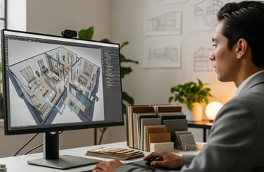
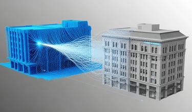
By leveraging cutting-edge LiDAR (Light Detection and Ranging) systems and Scan-to-BIM workflows, professionals can now capture millions of precise data points within minutes - creating a digital foundation for detailed floor plans, permit drawings, design planning, and renovation execution.
Why Precision Matters: The Role of As-Built Documentation
In architecture, construction, and renovation, precision is the backbone of every project. As-built documentation, also known as record drawings, captures the exact condition of a building at a given point in time. It reflects changes that may have occurred since the original design, ensuring that everyone involved - from owners to contractors - works from the same accurate reference.
Understanding As-Built Documentation
Once a building is completed, original blueprints often no longer reflect reality. Walls may shift slightly, mechanical and electrical systems may be updated, and finishes or layouts may be altered during construction or by tenants. Accurate as-built records ensure that:
Dimensions and spatial layout are precisely documented, including walls, openings, and structural elements.
Architectural details such as doors, windows, moldings, and ceiling heights are captured.
MEP systems (mechanical, electrical, plumbing) including ducts, piping, wiring, and fixtures are mapped.
Structural elements, including beams, columns, and load-bearing walls, are correctly documented.
Without precise as-built documentation, design decisions and construction plans risk going off course, leading to costly mistakes, delays, and inefficiencies.
The Risks of Imprecision
Even minor inaccuracies in as-built documentation can create significant challenges:
System conflicts: A new HVAC duct might interfere with existing plumbing if measurements are not precise.
Costly rework: Errors increase labor, material, and schedule costs.
Regulatory issues: Building permit submissions can be rejected if drawings do not reflect actual conditions.
Design inefficiencies: Interior designers may struggle to fit cabinetry, furniture, or custom fixtures without verified measurements.
In Greater Vancouver, where many homes and commercial buildings are older or complex, small discrepancies can cascade into substantial delays, cost overruns, and quality issues.
Beyond Construction: Long-Term Benefits
Accurate as-built documentation is not just useful during renovation - it's a valuable asset for the building's lifecycle:
Maintenance planning: Facility managers can locate critical systems quickly, minimizing disruption.
Future expansions: Accurate records streamline future remodels, additions, or retrofits.
Asset valuation: Verified measurements provide confidence for real estate appraisals.
Risk mitigation: Reduces miscommunication among teams, minimizing liability for contractors and designers.
In short, precision ensures clarity, efficiency, and confidence at every stage.
The Cost of Inaccuracy
Inaccuracy can be expensive, time-consuming, and disruptive. Even small measurement errors can ripple across a project, impacting design, schedule, budgets, and safety.
Real-World Impacts of Inaccurate Measurements
1. Design Conflicts and Clashes
Imagine a renovation where a new kitchen island is planned based on outdated measurements. Slightly misaligned walls or misdocumented plumbing can cause interference with vents, pipes, or electrical outlets. Resolving these clashes requires additional labor, materials, and potential redesigns - leading to frustration and delays.
2. Cost Overruns
Inaccurate documentation often results in unexpected change orders, increasing project costs. For example, ordering materials based on old blueprints may lead to waste, and subcontractors may be scheduled incorrectly. Even a minor discrepancy in wall lengths or ceiling heights can add thousands of dollars in unnecessary expenses.
3. Permit and Compliance Delays
In Greater Vancouver, building permits require precise as-built drawings. Submitting drawings that do not reflect actual conditions can stall approvals and add administrative costs.
4. Inefficient Use of Time
Working with incomplete or inaccurate data often requires repeated site visits for verification, slowing progress and delaying decision-making.
5. Impact on Stakeholders and Reputation
Measurement errors can damage trust between homeowners, contractors, and designers. Misaligned cabinetry or misplaced fixtures can reflect poorly on professionals and affect future business opportunities.
Example: Greater Vancouver Home Renovation
A major kitchen renovation begins using outdated floor plans.
Mid-project, contractors discover a plumbing line in a location not reflected in the drawings.
Resolving the issue requires rerouting pipes, modifying walls, and delaying finishing work.
Result: project costs rise by 15–20%, schedule extended by 2–3 weeks, and homeowners face unnecessary stress.
With accurate as-built measurements and 3D scanning, this conflict could have been identified during the design phase, avoiding rework entirely.
Broader Implications
Beyond immediate project impacts, inaccuracies can:
Complicate future renovations or expansions.
Introduce safety hazards if structural or MEP elements are misdocumented.
Reduce property value due to inefficiencies or compromised finish quality.
Key Takeaway: Investing in precise as-built measurements upfront is not just technical - it's a strategic risk management decision, saving money, time, and stress while enabling efficient project execution.
Traditional Measurement Techniques: The Foundation
Before the digital era, surveyors relied entirely on manual tools. These methods remain useful for small-scale spaces but are labor-intensive and prone to human error.
Common traditional techniques include:
Tape measures and rulers: Dependable for small rooms or objects.
Laser distance meters: Handheld devices that improve speed and accuracy.
Total station surveying: Combines a theodolite and electronic distance meter for highly accurate mapping, often used in site and infrastructure work.
While total stations provide precision, they require setup and time, making 3D laser scanning a faster, equally accurate alternative for detailed interior measurements.
The Digital Shift: Modern 3D Scanning Technologies
Over the past decade, the construction industry has undergone a dramatic transformation. While traditional tools remain foundational, digital reality capture - particularly 3D scanning - has revolutionized as-built measurement.
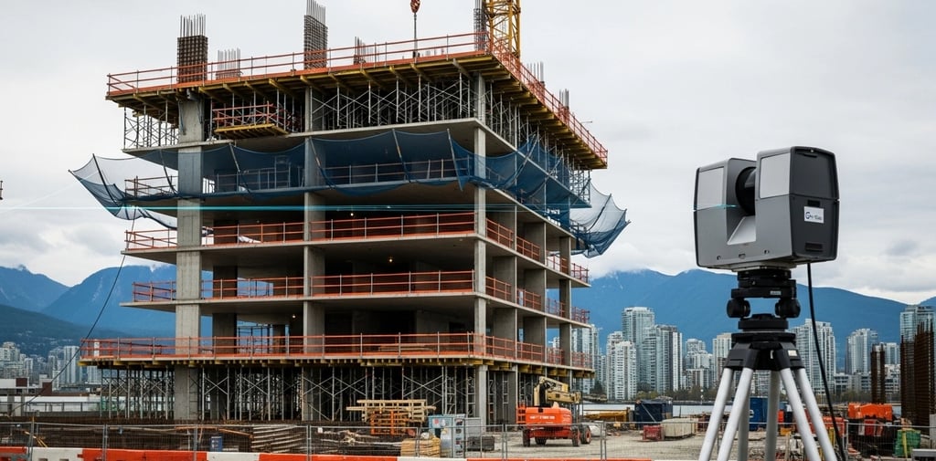
At the forefront is 3D laser scanning, often paired with LiDAR, which captures highly detailed, millimeter-accurate representations of any space - interior or exterior.
Why 3D Scanning is a Game-Changer
1. Unmatched Accuracy and Detail
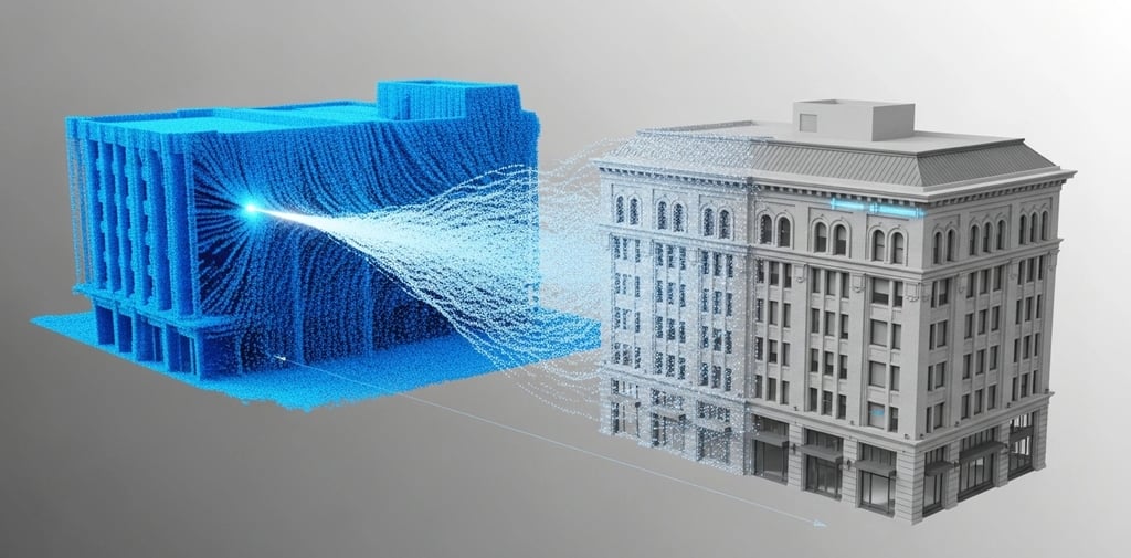
Modern scanners collect millions of data points per scan, creating a dense point cloud mapping every wall, floor, ceiling, fixture, and structural element. Subtle deviations, like warped walls or offset windows, are captured with precision. This is crucial in Vancouver, where older homes and legacy buildings often have irregular measurements.
2. Speed and Efficiency
A large renovation or commercial project that might take days or weeks with traditional methods can be captured in hours with 3D scanning, reducing labor costs and accelerating design and permit processes.
3. Safety Advantages
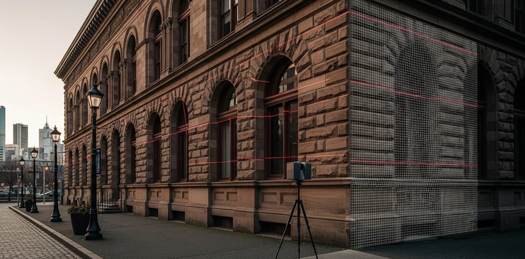
3D scanning allows remote data capture, minimizing the need for personnel in high ceilings, confined spaces, or hazardous areas - a critical benefit for heritage buildings, high-rise retrofits, and industrial spaces.
4. Comprehensive Documentation
3D scanning captures:
MEP systems behind walls or ceilings.
Structural components like beams and load-bearing walls.
Architectural details, including molding, trim, and floor patterns.
The result is a complete digital record for planning, construction, and facility management.
Types of 3D Scanning Technologies
LiDAR Scanning: Ideal for large-scale projects, multi-level renovations, and heritage sites. Example: scanning a multi-family building to capture floor layouts, MEP systems, and structural details in one session.
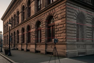
Terrestrial Laser Scanning (TLS): Tripod-mounted scanners capture high-resolution 3D point clouds for complex architectural surveys and industrial spaces.
Mobile and Handheld Scanners: Portable devices scan tight spaces, stairwells, or irregular areas to complement stationary scans.
Photogrammetry: Uses overlapping high-resolution images to reconstruct 3D models; less precise than LiDAR but useful for visual documentation and render-ready models.
Vancouver Example:
A downtown heritage home from the early 1900s had uneven floors and curved walls. Using 3D scanning:
The entire home was captured in under a day.
A precise point cloud documented every architectural and structural element.
2D floor plans and a 3D BIM model enabled accurate design planning while preserving historic integrity.
Types of 3D Scanning Technologies
LiDAR Scanning: Ideal for large-scale projects, multi-level renovations, and heritage sites. Example: scanning a multi-family building to capture floor layouts, MEP systems, and structural details in one session.
Terrestrial Laser Scanning (TLS): Tripod-mounted scanners capture high-resolution 3D point clouds for complex architectural surveys and industrial spaces.
Mobile and Handheld Scanners: Portable devices scan tight spaces, stairwells, or irregular areas to complement stationary scans.
Photogrammetry: Uses overlapping high-resolution images to reconstruct 3D models; less precise than LiDAR but useful for visual documentation and render-ready models.
Vancouver Example:
A downtown heritage home from the early 1900s had uneven floors and curved walls. Using 3D scanning:
The entire home was captured in under a day.
A precise point cloud documented every architectural and structural element.
2D floor plans and a 3D BIM model enabled accurate design planning while preserving historic integrity.
From Scan to Model: Turning Data into Action
Capturing a building is only the first step. The real power comes from converting raw scan data into actionable models, guiding design, construction, and facility management.
Workflow: From Point Clouds to Usable Models
1. Data Collection
Advanced 3D scanners or LiDAR devices generate millions of spatial points, forming a dense point cloud. Multiple scans ensure full coverage of complex areas like stairwells or industrial zones.
2. Data Processing and Cleanup
Specialized software:
Removes irrelevant objects (furniture, people).
Aligns multiple scans into a cohesive model.
Corrects distortions and fills gaps for clarity.
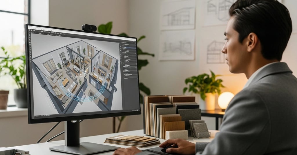
3. Conversion to BIM or CAD
The refined point cloud is transformed into:
2D CAD drawings for floor plans, elevations, and reflected ceiling plans.
3D BIM models with intelligent metadata (dimensions, materials, MEP specifications) for design and construction coordination.
Benefits of the Scan-to-BIM Process
Enhanced Collaboration: Stakeholders work from the same verified data.
Clash Detection: Conflicts between structural elements and MEP systems are identified early.
Design Efficiency: Interior designers and architects can plan with confidence.
Construction Accuracy: Contractors prepare precise material takeoffs and schedules.
Facility Management: Models support maintenance, retrofits, and future expansions.
Vancouver Example:
A multi-unit condo renovation:
Existing drawings were outdated.
3D scanning created a full point cloud of all floors.
Converted into a Revit BIM model including walls, ceilings, and MEP systems.
Enabled precise planning, reduced material waste, and stayed on schedule.
Deliverables from 3D Scanning Vancouver
Professional scanning services provide outputs tailored to project needs:
2D as-built floor plans and elevations (PDF, DWG)
3D BIM models (Revit .RVT)
Point cloud data (.RCP, .E57)
Site plans, sections, and reflected ceiling plans
These deliverables streamline design, construction, and facility management, reducing site visits and manual re-measurements.
Local Applications in Greater Vancouver
3D scanning has versatile applications across industries:
Real Estate: Accurate floor plans for MLS listings and virtual walkthroughs.
Contractors and Builders: Reliable takeoffs, cost estimates, and QA/QC monitoring.
Commercial Property Managers: BOMA-compliant floor area calculations and maintenance documentation.
Heritage and Restoration: Non-invasive capture and detailed conservation models.
Software and Tools Behind the Process
AutoCAD: Precise 2D documentation.
Revit & BIM Platforms: Convert scans into intelligent, data-rich 3D models for coordinated workflows.
These tools ensure all stakeholders work from the same verified digital model, improving accuracy, efficiency, and collaboration.
The Future of Measurement
The transition from tape measures to 3D scanning represents a permanent shift in how the industry documents existing conditions. Benefits include:
Speed: Projects captured in hours instead of days.
Precision: Millimeter-level accuracy reduces errors.
Safety: Less physical exposure to hazardous areas.
Sustainability: Fewer errors mean reduced material waste and rework.
Modern 3D scanning services in Vancouver deliver accurate models and drawings quickly, minimizing risk and enabling faster decision-making.
Conclusion: Measure Once, Build for a Lifetime
From tape measures to 3D laser scanning, as-built measurement has evolved into a cornerstone of modern construction and design. For architects, interior designers, contractors, and property owners in Vancouver, 3D scanning provides confidence, efficiency, and precision at every stage.
Whether you're renovating a heritage home, developing a commercial property, or planning a large-scale retrofit, accurate as-built measurements are the foundation of success.
Measure once - build for a lifetime
Ready to start your project with precision?
Contact MeasureBuilt today to discuss your as-built measurement needs and discover how 3D scanning can transform your next renovation or construction project.
MeasureBuilt: Where Details Matter
Contact Us
MeasureBuilt
Address
413-8188 Manitoba Street
Vancouver, BC V5X 4L8
Contacts
236-232-3335
emil@measurebuilt.com
When Details Matter!